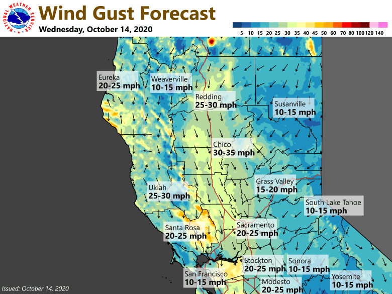
October 14, 2020 – High pressure will result in warm and dry weather this week. Breezy north to east winds will be possible through the week, strongest today and Thursday for the Valley, and tonight and Thursday night for the foothills and mountains, which will lead to critical fire weather conditions. Red Flag Warning until 11 AM PDT Friday.

Discussion
Except for a few high clouds across the far northern portion of the state, skies are clear across interior NorCal early this morning. North and east surface pressure gradients have been tightening across NorCal overnight behind the weather system that`s moving through the northern Rockies. The MFR-SAC gradient is currently approaching 8 mbs, and the RNO-SAC is 3-4 mbs. A few locales across the northern Sacramento Valley and surrounding terrain are already experiencing northerly wind gusts in the teens to lower 20s mph.

Hot and dry pattern with offshore winds will affect the region through the end of the week, and a red flag warning is in effect. Minimum RH will be in the single digits and teens the next several days with increasingly poor overnight recovery for most areas outside of drainage and valley bottoms.

Northerly winds will increase across the Sacramento Valley today and continue Thursday with gusts 30-40 mph. Northeast to east winds will increase tonight across the foothills and west slopes of the northern Sierra as the east surface gradient (RNO-SAC) tightens to around 10 mbs. The gusty easterly winds may subside a bit during the day on Thursday, but will pick up again Thursday night. Favored gaps and canyons (mouth of the Feather River) may see local gusts of 40-50 mph Thursday and Friday mornings.
Surface gradient forecast to slacken considerably Friday and Saturday resulting in lighter winds, though some breeziness may linger across the northern Sacramento Valley. Temperatures will remain well above average (10-15 degrees) through the end of the week.
Extended Discussion (Sunday through Wednesday)
Models differ through the extended period leading to forecast uncertainties. All solutions point to dry weather, but differences in temperature forecasts would result. Ensembles lean towards the GFS/FV3 solution which maintains EPAC high as being dominant synoptic feature with meso closed upper low remaining off the CA coast. Gradual cooling trend expected through the extended forecast period with high temperatures returning to near normal by Wednesday.

