
September 26, 2020 – Temperatures will warm over the weekend along and will be accompanied with drier and windier conditions. This will lead to critical fire weather conditions starting Saturday night and continuing through Monday morning. Above normal temperatures and dry conditions linger into late next week.

Discussion
Infrared satellite imagery shows some high clouds traversing over northern California this early Saturday morning with the west- east zonal flow overhead. Over the next 24 hours, an upper level ridge off the West Coast will build and nudge eastward, and will settle on top of northern California well into next week. Not only will much of northern California be subjected to well above normal temperatures, but also an offshore wind event that will lead to very critical fire weather conditions.
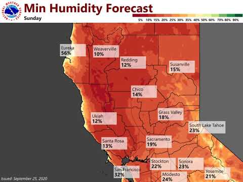
Some of the higher resolution models are now beginning to capture the upcoming north to east wind event. The latest 00Z 3-km NAM shows winds at 925 mb (about a half-mile above the surface) beginning to increase through the day on Saturday across the northern Sacramento Valley, and then ramp up to 35 to 45 kt after sunset. At the surface, this will translate to speeds of 15 to 30 mph with gusts in the 40 to 45 mph range, with isolated higher gusts above 50 mph quite conceivable, particularly in the wind- prone valleys/gaps (e.g., Jarbo Gap). While the winds may marginally subside during the day on Sunday, temperatures will be hot and relative humidity values will bottom out in the teens and single digits. A combination of the very dry fuels, low relative humidity values, and windy conditions will lead to dangerously critical fire weather conditions. A renewed development of strong, gusty north to east winds will likely occur after sunset on Sunday, and continue into Monday morning. Should also note that very poor relative humidity recoveries are forecast for both Saturday night and Sunday night. Consequently, the Red Flag Warning is scheduled to go into effect at 9 pm PDT Saturday and go through 2pm PDT Monday. Additionally, a Wind Advisory will go into effect at 2 am PDT Sunday for the locations that will most likely be impacted by the strongest winds (e.g., West Side of the Sacramento Valley, northern Sierra foothills).
In terms of the heat, widespread 90s are forecast through the weekend and into next week for the Sacramento Valley, equating to about 10 to 15 degrees above late September climatological normals. The associate heat risk will generally be low to moderate, mainly impacting sensitive groups and/or those outdoors for prolonged periods.
Extended Discussion (Wednesday through Saturday)
Upper level ridge will remain parked over the West Coast through much of the next work week. This will result in a prolonged period with widespread 90s for the Sacramento and northern San Joaquin Valleys, likely through the end of September and into the beginning of October. For those keeping tally, Downtown Sacramento is has recorded 105 days this year at/above 90 deg F, ranking second all-time. The record is 110 days, which occurred in 1984. If the present forecast remains on track, 2020 will overtake 1984 by the end of next week.
Dry conditions are forecast to prevail through the extended period.