
Happening Now is a feature designed to bring updates, announcements and info on news items throughout the day. You are invited to participate. See a road closure? A business opening? A smoke plume? Storm-related mishaps like downed trees, power lines, road or other flooding? Email us at news@yubanet.com or call 530-478-9600 to let us know. You can also text us reports to 530-409-9888, but please don’t text or call while driving. Thanks!
September 30, 2017 at 7:07 PM Small fire near Maltman and Joerschke Drive quickly contained
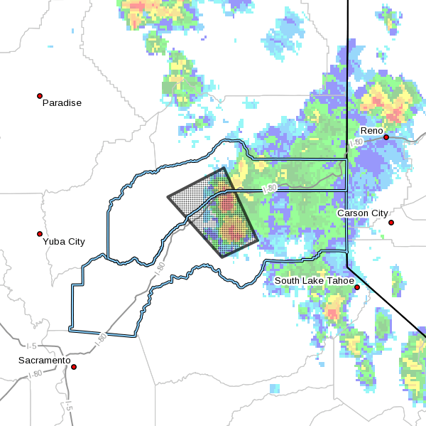
September 30, 2017 at 10:49 AM Red Flag Warning through Monday. Although interior NorCal will see a cooling trend over the weekend, dry conditions with breezy to gusty north winds will enhance fire weather concerns. Strongest winds expected Sunday afternoon into evening.
September 29, 2017 at 8:10 PM Three “grownups” thought it was OK to use racial slurs on a kid. Bystanders looked the other way. Then, the community reacted: //yubanet.com/regional/love-not-hate-makes-grass-valley-great-photo-gallery/
September 29, 2017 at 9:13 AM A touch of Fall, some breezy north winds for the weekend. Cooler today, with high temperatures 5 to 10 degrees cooler than yesterday.
September 29, 2017 at 8:50 AM Comcast customer service reports the outage in Yuba and Nevada counties will be resolved within the hour. Outage in Auburn and Roseville areas ETA approximately 2 hours with some customers being restored now.
September 29, 2017 at 8:15 AM A large Comcast outage is affecting customers between Marysville and Sacramento. A maintenance issue overnight caused the outage. According to reports, a fiber cable in Yuba County is being repaired. No estimated time of restoration yet.
September 28, 2017 at 10:59 PM Power is estimated to be restored by 2:30 am for the remaining 200+ customers along West Main Street. A PG&E crew is on site to repair damaged insulators.
September 28, 2017 at 9:04 PM The outage in Grass Valley is reduced to 273 customers from West Main Street to High Street and Scotia Pines Circle.
September 28, 2017 at 8:26 PM Outage in Grass Valley has been reduced to 2,030 customers.

September 28, 2017 at 7:44 PM Power outage affecting 3,033 customers in Grass Valley. PG&E assessment crew is en route to the outage. Estimated time of restoration is 10:15 pm.
September 28, 2017 at 3:21 PM CAL FIRE Butte County Fire Units en route to vegetation fire. Humboldt Rd x Soda Springs Rd. Butte Meadows. Building column showing from the valley floor. The fire is estimated at 25 acres.
September 28, 2017 at 8:49 AM Possible traffic collision, heard only, on McCourtney Road near Patterson Valley Road.
September 28, 2017 at 8:34 AM Cool down on the way for the weekend. Friday through Sunday will see a trough of low pressure develop over NorCal. No precipitation associated with the low.
September 27, 2017 at 9:29 AM Above normal temperatures today, slight cooling on Friday. A warm late September day is in store for NorCal with readings about 5 degrees above normal at most locations.
September 27, 2017 at 9:07 AM Watch the September 27, 2017 NID Board meeting live now.
September 26, 2017 at 6:30 PM Per CAL FIRE: Jasper Fire, Jasper Lane & Levee Road, 1 mile NE of Wheatland (Yuba County) is 26 acres and 100% contained.
September 26, 2017 at 4:44 PM All aircraft has been released from the Jasper Fire. Mop-up is in progress
September 26, 2017 at 4:03 PM Firefighters are making good progress on the Jasper Fire near Wheatland. Approximately 40 acres of grass, one flank is secure, air tankers are working the open flank.
September 26, 2017 at 3:19 PM Vegetation fire on Jasper Lane west of Camp Far West in the Wheatland area. Full wildland dispatch on order. First unit has arrived on scene.
September 26, 2017 at 9:03 AM Breezy north winds bring increased fire danger through early Wednesday morning. High pressure over the eastern Pacific and west coast will bring warm and very dry conditions over the next several days.
September 25, 2017 at 4:51 PM Full wildland dispatch, with aircraft for a vegetation fire with structures threatened off Hwy 20 on Sicard Flat Road and Wandering Way in Browns Valley. Update: //yubanet.com/Fires/flat-2/
September 25, 2017 at 4:01 PM A light pole in the roadway on Hwy 49 in the southbound lanes near Lime Kiln Road. Please reduce speed and use extreme caution in the area. Emergency services en route.
September 25, 2017 at 2:51 PM All units have left the grass fire at Camp Far West.
September 25, 2017 at 1:48 PM Dispatch for the vegetation fire at Camp Far West is being scaled back.
September 25, 2017 at 1:46 PM First unit has arrived at scene at Camp Far West, reporting a 100 by 20 ft roadside spot.
September 25, 2017 at 1:40 PM Full wildland dispatch to Camp Far West on Camp Far West Road at the lake.
September 25, 2017 at 1:09 PM Brushfire northeast of Chico is called the 32 Fire. Updates: //yubanet.com/Fires/32-2/
September 25, 2017 at 9:39 AM Campfire next to a motorhome in the Jones Bar Road/Owl Creek Road area. Units en route.
September 25, 2017 at 8:31 AM NWS Sacramento: Critical Fire Weather Conditions Through Wednesday Morning
September 25, 2017 at 7:37 AM Red Flag Warning extended to Wednesday, warmer and much drier weather on tap. Gusty northerly or offshore winds over the northern and western Sacramento Valley and adjacent foothills will redevelop again this afternoon and tonight into portions of the Sierra Nevada, continuing through early Wednesday morning. The combination of offshore winds and dry airmass are expected to bring critical fire weather conditions.
September 24, 2017 at 10:16 PM Vehicle into a house on the 11900 block of Rough & Ready Highway. Numerous emergency vehicles en route.
September 24, 2017 at 8:09 PM Firefighters are on scene of a vegetation fire on Honeysuckle Road off North Bloomfield. The fire is contained at less than 1/4 acre. Many of the resources ordered to the incident are being released.
September 23, 2017 at 8:55 PM Auburn Firefighters on social media: As stated earlier, Auburn City Firefighters, along with resources from other agencies, have responded to multiple structure fires in the area of Magnolia Ave., Linden Ave., Cherry St., Hillmont Ave., and Tennis Way. PG&E has cut power to the area leaving 109 homes currently without power. Emergency crews are still at scene, so please avoid the area. It will be reopened as soon as possible.
September 23, 2017 at 5:44 PM Multiple structures involved in downtown Auburn. Fire started in one home and spread to several (3-4) other homes. Nine fire agencies are on scene to suppress the fire and stop it from spreading. Please avoid the area.
September 23, 2017 at 10:18 AM Red Flag Warning until Tuesday, breezy north winds and warming temperatures this weekend. Gusty North winds and warmer today. Wind speeds from 20 to 30 mph at times over the northern and central Sacramento Valley.
September 22, 2017 at 8:05 PM Firefighters have mitigated the chimney fire on Woodland Way.
September 22, 2017 at 7:40 PM Residential structure fire, chimney fire, on Woodland Way in the Glenbrook Basin, Grass Valley. Units en route.
September 22, 2017 at 6:35 PM Per Caltrans, roadway clear on Hwy 20 near Browns Valley due to a crash.
September 22, 2017 at 6:19 PM Illegal debris burn on Dog Bar Road near Lorrie Drive. Firefighters en route to remind a homeowner that the burn ban is still in effect and extinguish the pile.
September 22, 2017 at 6:04 PM One way traffic control on Hwy 20 near Loma Rica Road after an accident. Traffic is backed up and at a standstill. Use an alternate route if possible. Also on Hwy 20 near Knaus Court (east of Sunridge Court) a solo vehicle accident has the westbound lane closed.
September 22, 2017 at 2:39 PM Smoke report from Oregon Peak, steady small white column. Could be the Skyline fire on the Tahoe National Forest. Pike County lookout confirms this is the same fire.
September 22, 2017 at 1:58 PM Air Attack 210 was over the small lightning-caused fire at the north side of Bullards Bar, assisting TNF firefighters.
September 22, 2017 at 1:06 PM
There is NO tsunami expected due to this earthquake off the NorCal coast. https://t.co/4TUd5chHkX
— NWS Sacramento (@NWSSacramento) September 22, 2017
September 22, 2017 at 11:18 AM Non-injury accident on the 11000 block of La Barr Meadows Road. Both cars are off the roadway.
September 22, 2017 at 11:17 AM Emergency services are on scene of a two-car accident on Tyler Foote Road near Oak Tree Road in North San Juan.
September 22, 2017 at 8:00 AM One more day of cool weather, weekend warmup brings back summer-like temperatures. One more day of cooler weather and mountain rain & snow before temperatures begin warming again. Summer-like temperatures are expected by the weekend.
September 22, 2017 at 7:58 AM The 2017 autumnal equinox, the official change of season, occurs on Sept. 22 at 1:02 p.m. PDT, according to the U.S. Naval Observatory.
September 21, 2017 at 8:18 PM
#Traffic #Update for Hwy 20 east of Nevada City: The roadway is open and clear. Drive safely
— CHP Grass Valley (@CHPgv) September 22, 2017
September 21, 2017 at 8:16 PM First unit has arrived in the Keller Road area, recommends all units reduce to code 2 (no lights or sirens). Units to stage on Melody and Big Oak Lane for now. So far, no fire located only lights from a growhouse…
September 21, 2017 at 8:09 PM Report of a possible vegetation fire in the Smartsville area on Keller Road near Eldore Road. Multiple engines en route.
September 21, 2017 at 7:55 PM Per CHP Grass Valley: Traffic Update for Hwy 20:
One-way traffic controls are in place and cleanup is going well. Roadway expected to be fully open again soon.
September 21, 2017 at 7:52 PM Units on scene are requesting some additional resources, the fire is at the Recology Auburn Placer Center. Resources are needed to protect the additional trash piles and the buildings.
September 21, 2017 at 7:36 PM Large trash pile on fire near the awning of a commercial structure on Shale Ridge Road. First unit has arrived on scene.
September 21, 2017 at 6:08 PM
Highway 20 at Steephill will be shut down for an unknown amount of time due to a non injury rollover. pic.twitter.com/Oi6yNvFNPR
— NCCFIRE (@NCCFIRE) September 22, 2017
September 21, 2017 at 5:52 PM Per CHP Grass Valley: Hwy 20 closed approx. 1 mile east of Nevada City due to overturned semi-truck and spilled material. No estimate to clear.
September 21, 2017 at 5:44 PM Tahoe National Forest firefighters have located the three lightning-caused fires in the Camptonville area. All fires are staffed, burning at a slow rate of spread with little potential for spread. The fires are named Frenchy, Skyline and Pike respectively.
September 21, 2017 at 5:43 PM Hwy 20 is blocked at Steep Hill just outside of Nevada City. Emergency services are on scene, driver of the overturned big rig is uninjured.
September 21, 2017 at 5:33 PM Overturned big rig on Hwy 20 at Steep Hill.
September 21, 2017 at 4:31 PM
Our first chain controls of season, SR 267 Northstar to Kings Beach, chains or 4WD/AWD required. Check https://t.co/HS687UgNj7 for updates. pic.twitter.com/EDJPE8JvKC
— Caltrans District 3 (@CaltransDist3) September 21, 2017
September 21, 2017 at 4:27 PM Caltrans: In El Dorado County, US50 has only one lane open in both directions approximately 2 miles west of Ice House Rd near Bridal Veil Falls due to a roadbed failure. There is no estimated time of reopening all lanes. Motorists may experience delays in the area. A detour is not provided.
September 21, 2017 at 4:07 PM NWS Sacramento: Showers and isolated thunderstorms through this evening. Doppler radar showed scattered showers and isolated thunderstorms over the Sierra. Some of these showers were heavy and producing brief accumulations of snow and slush on area roads around the Tahoe Basin. While widespread heavy snowfall is not expected, be prepared if you must travel into the Sierra this evening. Take chains just in case and allow for extra time to reach your destination. The closer we get to sundown, the longer it will take for the snow and slush to clear. Check road conditions before leaving.
September 21, 2017 at 3:55 PM The lightning over the Bullards Bar area has ignited at least three small fires. All are single trees on fire with minimal ground fire. Air Attack 210 reported two fires in the Camptonville area and FEO 331 reported the Pike Fire, also in the Camptonville area. Per Air Attack 210 all can be suppressed by one engine each.

September 21, 2017 at 3:21 PM Caltrans: WB 80 crash cleared but very low visibility EB from Kingvale to Donner Summit. Slow going in both directions.
September 21, 2017 at 2:53 PM Smoke check, reported by lookout, in Alta Sierra near Rattlesnake. Engines en route.
September 21, 2017 at 1:21 PM Strong thunderstorm currently over Bullards Bar, headed south. Gusty winds and numerous downstrikes reported.
September 21, 2017 at 12:57 PM Caltrans update: WB I-80 crashes have closed freeway at Eagle Lakes. Traffic being turned at Kingvale. CHP investigating and ETO @ 6 p.m.
September 21, 2017 at 11:38 AM Caltrans: WB I-80 blocked for multi-vehicle collision. Holding WB traffic at Crystal Springs. Expect long delay as area cleared.
September 21, 2017 at 11:28 AM A confirmed fatality at the accident on westbound I-80 near Eagle Lake. 4-car pile up and a car vs a tree.
September 21, 2017 at 11:17 AM Multiple accidents on I-80: westbound at Nyack, three vehicles involved. I80 W / Eagle Lakes Rd single vehicle. I80 W / Soda Springs, 2 vehicles with a horse trailer.Emergency services are on scene at all incidents. Expect slowdown on westbound I-80.
September 21, 2017 at 7:41 AM Last day of Summer brings a winter weather advisory. Snow will accumulate today over the Sierra, including the I80 and Highway 50 corridors. Up to a storm total of 6 inches could fall at Donner Pass. A Winter Weather Advisory is in effect until 11 pm tonight. Use caution driving in the mountains today, if you must travel. Expect winter weather driving conditions!
September 20, 2017 at 5:58 PM Per CHP Grass Valley: Rough&Ready Hwy is clear of the earlier collision.
September 20, 2017 at 4:59 PM Overturned vehicle on Rough&Ready Hwy near Stagecoach Way. Emergency services en route.
September 20, 2017 at 4:43 PM Leave some extra distance between cars, wet roads increase your stopping distance. Remember when your windshield whipers are on, so must your headlights.
September 20, 2017 at 11:40 AM Lanes blocked on Hwy 174 at Cedar Ridge after a head-on collision between two passenger cars. CHP and emergency services on scene, use an alternate route if possible.
September 20, 2017 at 7:57 AM Cool and some light precip as early season system arrives today. Wednesday, Thursday weather system will bring low precipitation amounts to the mountains & Northern Sacramento Valley and light snow showers to the Sierra crest.
September 19, 2017 at 8:20 AM Cooler weather this week with a chance of showers into Friday. Cooler temperatures this week as a weak weather system moves through interior NorCal. Rain is expected over the mountains & northern Sacramento valley, and snow flurries are possible over the Sierra late Wednesday through Thursday!
September 18, 2017 at 11:53 AM Units at the movie complex report light smoke in one of the theaters, possible a/c malfunction. They can handle with resources at scene. All incoming resources are canceled and returning to their stations.
September 18, 2017 at 11:49 AM Numerous engines en route to Nevada Street in Auburn, report of a possible commercial structure fire at the Regal Cinemas Auburn. First unit at scene reports no smoke showing, the building is still occupied. They are out investigating.
September 18, 2017 at 11:23 AM Two vehicles involved in an accident on Penn Valley Drive. All occupants are out of the vehicles, minor damage only. Firefighters on scene report one lane of Penn Valley Drive is blocked.
September 18, 2017 at 9:53 AM Firefighters have resolved the issue at the Colfax gas station, no fire and all units are leaving.
September 18, 2017 at 9:21 AM Beacon Gas Station reports they have evacuated everyone from the business and the HVAC system has been turned off. First engines are arriving on scene.
September 18, 2017 at 9:20 AM Smoke and electrical fire smell at Beacon Gas Station in Colfax. Numerous engines en route.
September 18, 2017 at 9:12 AM Lines across the roadway, unknown if power or phone lines. CHP and fire personnel en route to Wilson Way / Scott Forbes Rd in Yuba County.
September 18, 2017 at 7:30 AM This last week of Summer will feel like Fall. The trend toward cooler temperatures returns to interior NorCal today.
September 17, 2017 at 4:10 PM Air tankers and helicopters are headed to two fires out of the area. On near Shingle Springs, one in Butte County.
September 17, 2017 at 10:23 AM Seasonal temperatures today, cooler weather to return. Cooler temperatures expected early next week!
September 15, 2017 at 2:34 PM Air Attack 230 is over the structure fire on Lost Lake Road in the Greenhorn/You Bet area. Two fully involved trailers, several outbuildings and minimal extension to the wildland. Fire resources on scene can handle the incident.
September 15, 2017 at 2:34 PM Engines en route to a possible vegetation fire in Lost Lake Road.
September 15, 2017 at 12:51 PM Here is a photo gallery of today’s fire near Juvenile Hall. Fire near Juvenile Hall contained – escaped camp fire again?

September 15, 2017 at 10:34 AM The fire next to Juvenile Hall, on county property, has a hose line around it and firefighters are working in very steep terrain to build handline around it. While still under investigation, the fire appears to be an escaped camp fire.
September 15, 2017 at 9:19 AM Several engines are on scene, there is no threat to Juvenile Hall. Firefighters are working to contain the fire. As a reminder, the burn ban is still in effect!
September 15, 2017 at 9:15 AM The fire is actually located on the other side of Hwy 49, near Juvenile Hall. Firefighters have discovered an escaped debris burn, approximately 50 by 30 ft. burning at a slow rate of spread in light fuels.
September 15, 2017 at 9:13 AM Firefighters cannot make access from Robinson King Road above the small fire, they will have to walk in from Hirschman’s Pond.
September 15, 2017 at 9:02 AM First unit on scene reports they have a visual on the smoke, they will access Hirschman’s Trail to get to the fire.
September 15, 2017 at 9:00 AM Smoke on Indian Flat Road is reported to be in the vicinity of Robinson King Road, in the Hirschman’s Pond area. Several engines en route for the smoke check.
September 15, 2017 at 8:58 AM Smoke check on Indian Flat Road in Nevada City, report of a persistent column of white smoke in the area. No flames seen.
September 15, 2017 at 8:33 AM This just in: Bill Smethers announces candidacy for Nevada County Sheriff
September 15, 2017 at 8:16 AM Seasonally warm weekend, significantly cooler week ahead. High temperatures today warm back to near average for mid-September.
September 14, 2017 at 4:01 PM Power lines down, no arcing, at the Gold Country Mobile Home Park. Units en route, PG&E has been notified.
September 14, 2017 at 8:34 AM NWS Sacramento: A few thunderstorms will be possible across Northern CA mountains today, but otherwise mostly dry weather with seasonal temperatures are expected through the weekend. A major pattern shift then begins next week, with much cooler weather likely across the region. There is less confidence in the precipitation forecast, but at least a few of our computer models suggest the potential of light, high elevation snow. The primary impact with this cooler pattern would be to high elevation travelers and outdoor enthusiasts, who may not be prepared for an early season pattern change.
September 14, 2017 at 6:33 AM Coolest day of the week today, seasonal temperatures return for the weekend. The cooling trend continues Thursday for interior NorCal. Thursday will be the coolest day of the week, though valley temperatures expected to remain in the 80s through the weekend. Thunderstorms are possible over the Sierra once again.
September 13, 2017 at 10:45 AM CHP Grass Valley update: Hwy 49 is clear after the major injury traffic collision near Rincon Way (south of Grass Valley) this morning.
September 13, 2017 at 9:36 AM After a major injury accident near Rincon Way, southbound HWY 49 has 1 lane open and northbound has both lanes open, however motorists may experience congestion and delays in the area.
September 13, 2017 at 9:26 AM The lightning map shows quite a few downstrikes: //yubanet.com/regional/lightning-map-212-downstrikes-on-the-tahoe-national-forest-on-tuesday/
September 13, 2017 at 9:14 AM Major injury collision on Hwy 49 at Rincon Way. Traffic is at a standstill. Use an alternate route if possible.
September 13, 2017 at 9:11 AM Watch the NID Board meeting live now: //yubanet.com/regional/livestream-nid-board-meeting-september-13/

September 13, 2017 at 7:29 AM Two small fires, caused by lightning, continue to burn/smolder near the Town of Washington. No threat to the town.
September 13, 2017 at 7:10 AM More cooling, less thunderstorms. The low pressure system off the central California coast will move inland today into Thursday. Showers and thunderstorms (along with cooler temperatures) will be possible today, then taper off for the remainder of the week.
September 12, 2017 at 5:59 PM Possible vegetation fire on Hwy 20 near Omega Road. Units en route.

September 12, 2017 at 5:41 PM Accident on Hwy 49 and Shoshoni Trail Court. Vehicle off the roadway, in a driveway. The same car was off the roadway on Hwy 49 earlier on, according to a resident. CHP and NCSO on scene.
September 12, 2017 at 5:40 PM Caltrans TrafficAlert I-80 WB closed at Hirschdale for jack-knifed big rig and big rig/vehicle crash. No ETO. Please SLOW DOWN on wet roadways!
September 12, 2017 at 4:34 PM Vehicle accident on southbound Hwy 49 at Lone Star Road, reported as a vehicle on fire. PG&E crews on scene have extinguished the fire. First fire unit on scene requests the two closest engines to continue in. All others cancel.
September 12, 2017 at 4:22 PM NWS Sacramento: A Strong thunderstorm will affect northeastern Placer and central Nevada counties until 500 pm. At 417 PM PDT, a strong thunderstorm was located 8 miles east of Sugar Pine, or 9 miles southeast of Baxter, moving northwest at 20 mph. Winds in excess of 30 mph and dime size hail are possible with this storm. Locations impacted include: Baxter, Blue Canyon, Scotts Flat, Emigrant Gap, White Cloud Campground, Lake Spaulding and Skillman Campground. Heavy downpours are also occurring with these storms. Slow down on wet roadways.
September 12, 2017 at 4:16 PM Most units en route to Loma Rica are being canceled, including all aircraft.
September 12, 2017 at 4:15 PM First unit on scene reports a 20 by 20 spot, contained on one side by greenery.
September 12, 2017 at 4:13 PM Second caller reports the fire possibly on Prairie Creek Lane, off Loma Rica Road. Approximately the size of a house now, burning in grass.
September 12, 2017 at 4:07 PM Report of a vegetation fire on Fruitland Road in Loma Rica, full wildland dispatch on order.
September 12, 2017 at 2:31 PM Confirmed false alarm at the Ready Springs School. Firefighters are resetting the alarm and returning to their stations.
September 12, 2017 at 2:20 PM CAL FIRE/Butte County Fire: CampFire [Update] Firefighters hiking in to fire 4,000 ft mid slope above Pulga Rd. Fire size about 1 acre. Air resources holding the fire.
September 12, 2017 at 2:18 PM Students are out of the building at Ready Springs School. First unit at scene reports nothing showing from the outside.
September 12, 2017 at 2:16 PM Commercial fire alarm at the Ready Springs School in Penn Valley.
September 12, 2017 at 2:15 PM Heavy precip in the Downieville area, with multiple downstrikes reported.

September 12, 2017 at 12:51 PM NWS Sacramento: A strong thunderstorm will affect north central Placer and northeastern Nevada counties until 1:45 pm. At 12:50 pm, a strong thunderstorm was located over Cisco, impacting Interstate 80 and moving west at 15 mph. Winds in excess of 30 mph and half inch hail are possible with this storm. Locations impacted include: Blue Canyon, Cisco, Emigrant Gap, Kingvale, Lake Spaulding and Rattlesnake Mountain.
September 12, 2017 at 12:51 PM Caltrans: Thunderstorms are firing near the Sierra crest, including a strong storm along I-80 near Kingvale. Slow down on wet roads!
September 12, 2017 at 12:37 PM Camp Fire near Concow: Air Attack plane reporting 1.5 acres mid slope between Camp Crk Rd and Dixie Rd. Working on getting ground resources in.

September 12, 2017 at 12:11 PM Tankers 88 and 89 are en route to the fire in Butte County near Concow.
September 12, 2017 at 12:02 PM CAL FIRE/Butte County Fire Firefighters responding to a vegetation fire in a remote area of Camp Creek Rd at Dixie Rd near Flea Mtn., east of Concow.
September 12, 2017 at 12:01 PM Non-injury collision on eastbound Hwy 20 at Scotts Flat Rd. Roadway is clear.
September 12, 2017 at 10:30 AM Report of a possible new lightning fire near Sterling Lake, north of the Hwy 20 I-80 junction. Units en route.
September 12, 2017 at 10:26 AM 3,600 PG&E customers in Paradise without power after vehicle hits a pole on Clark Rd s/o Pearson Rd. Road closure while crews remove the down line.
September 12, 2017 at 10:10 AM The single tree on fire is in the Mobley Springs area, north of the townsite of North Bloomfield. Crews and a helicopter en route to the fire. The fire is reported as a single tree, low rate of spread, low potential.
September 12, 2017 at 10:01 AM Eldorado National Forest units are responding to the 1/2 acre Long fire. The fire is on the Georgetown District in the area of Long Canyon.
September 12, 2017 at 9:44 AM Report of a possible tree on fire, reported by Pike County lookout, in the North San Juan area. Oregon Peak lookout cannot see the smoke. Possibly a lightning strike from last night.
September 12, 2017 at 9:17 AM Cooling trend starts today, chance of thunderstorms persists. A weather system off the Central California coast will bring moist air northward this week. Showers and thunderstorms, along with cooler temperatures, will be possible across much of Northern California through Wednesday. Dry weather returns Friday through the weekend.
September 11, 2017 at 8:01 PM Just heard from Theo’s humans – he has been found. They are on their way to pick him up now. Thanks everyone for keeping an eye out for him.
September 11, 2017 at 5:32 PM Lit campfire halfway down the trail on Pennyweight Trail in the Colfax area. Units en route.

September 11, 2017 at 1:07 PM From neighbors on Lake Vera: Our beloved Theo disappeared from his dog sitter’s while we were away and he may be trying to get back home. Please help us find him. Theo is black, brown and white: imagine a shepherd shape with beagle coloring and border collie size. He has a limp in his left front elbow that the vets can’t cure, but he’s a fast runner and agile climber so he could have traveled far. Theo is 3 years old. We believe he left his dog-sitter specifically to find us because he has separation anxiety, so he could be anywhere between his lost point on Indian Springs Rd in Penn Valley and our home off Lake Vera/Purdon Rd outside Nevada City.
Theo is a rescue dog and very shy of strangers but strongly bonded with us. If you see a dog that might be Theo, he’s most likely to approach if you sit down on the ground when calling his name – he’s less intimidated by strangers if they’re more on his level. If you aren’t able to get close to him, please still call us and we’ll target our search efforts in that location. Thank you!!!
September 11, 2017 at 8:27 AM The Point fire in Camptonville has been contained, firefighters working on mop-up.
September 11, 2017 at 8:22 AM Power outage is affecting 791 customers on both sides of Hwy 20 down to Scotts Flat Road on the south side and North Bloomfield on the north side. Estimated time of restoration is 10:45.
September 11, 2017 at 8:21 AM Camptonville Fire is on scene, IC reports they have water on the fire. With one crew and one additional engine they should be able to control the ire. There is no threat to structures. Incoming units are staging on Weeds Point Road due to access issues. Most resources are expected to be released shortly.
September 11, 2017 at 8:11 AM First unit has arrived on scene at the fire in Camptonville, reports approximately 1/4 acre. Appears to be a vehicle fire with slight extension to the wildland.
September 11, 2017 at 8:02 AM Power outage along Hwy 20, on Scotts Flat Road and up to the Town of Washington. No estimated time of restoration yet.
September 11, 2017 at 7:58 AM The fire is now reported as a vegetation fire only. All units to approach the fire from the south through the Pendola Extension road due to a washout on Weeds Point Road.
September 11, 2017 at 7:37 AM Report of a residential structure fire, with possible extension to the wildland, in the Weeds Point Road and Youngs Hill Road in Camptonville. Numerous engines en route.
September 11, 2017 at 6:56 AM Hot weather continues, heightened chance of thunderstorms. Hot temperatures will continue into the start of the week but things will be cooling off by the end of the week. Scattered showers and a few thunderstorms will be possible even in the valley through mid-week.
September 10, 2017 at 6:47 PM First unit at scene on eastbound I-80 near Yuba Gap reports an extinguished vehicle fire, no extension to the wildland. All incoming units are canceled.
September 10, 2017 at 6:43 PM Air Attack is over the I-80 area, reports nothing showing in the Yuba Gap vicinity. Tanker 88 is returning to the Grass Valley/Nevada City area.
September 10, 2017 at 6:25 PM Passenger vehicle fire, with extension to the wildland,eastbound I-80 just east of Eagle Lake. Full wildland dispatch, including aircraft, on order.
September 10, 2017 at 4:30 PM First unit has arrived at scene on Dog Bar Road, reports a 10 by 10 spot extinguished by the homeowner. All incoming units can cancel.
September 10, 2017 at 4:28 PM Medical rescue 1/2 mile in from the covered bridge at Bridgeport. Units en route.
September 10, 2017 at 4:27 PM Homeowner reports a spot about the size of a vehicle on fire. Air Attack 230 approaching the incident reports no smoke showing.
September 10, 2017 at 4:20 PM Report of a vegetation fire on Dog Bar Rad, across of Morning Sun Lane near Higgins Fire Station 22. Full wildland dispatch en route.
September 9, 2017 at 3:59 PM Reported fire in North San Juan is reported at a 3 by 3 spot, started by mowing. Residents working on extinguishing it.
September 9, 2017 at 3:57 PM Report of a vegetation fire being extinguished by locals on Byron Road at Robinson Road in North San Juan. Units en route.
September 9, 2017 at 1:33 PM First unit at scene reports at 10 by 10 spot at the end of New Mohawk. One more engine to continue in, all others can cancel.
September 9, 2017 at 1:27 PM Smoke report from Banner Mountain lookout, vegetation fire possibly at the end New Mohawk Road near the parking lot in Nevada City. Units en route.
September 8, 2017 at 1:25 PM Caltrans: Highway 20 just east of Marysville is ALL CLEAR, however clean-up efforts continue so please be alert for workers and equipment in area.

September 8, 2017 at 1:24 PM Thanks to reader Paul Paterson for this photo: Picture taken in broad daylight off 174 just north of the Bear River 12:30 pm Friday 9/8/2017
September 8, 2017 at 7:39 AM Truckee PD: Heavy traffic on Hwy 267 bypass & Brockway Road due to road construction. Allow extra drive time or use an alternate route.
September 8, 2017 at 7:13 AM Warming back up, thunderstorms will be possible across higher terrain through early next week. Warming trend with mountain thunderstorms possible for NorCal. Keep in mind that lightning could increase risk of wildfires. Stay alert!

September 7, 2017 at 10:41 AM 116 lightning strikes hit the Tahoe National Forest yesterday.
September 7, 2017 at 9:20 AM The National Weather Service in Sacramento has cancelled the Red Flag Warning for Sierra, Plumas County, Nevada County, Placer County, Yuba County, El Dorado County. The threat for abundant lightning has shifted out of the area.
September 7, 2017 at 9:15 AM Hwy 20 in Yuba County between East 22nd Street and Woodruf Rd, the roadway is closed due to an overturned tanker truck. There is no detour provided and no estimated time of opening.
September 7, 2017 at 8:49 AM CAL FIRE Update: More than 9500 firefighters continue to battle 24 large wildfires in California. Showers and thunderstorms will continue in Northern California today. Most of the showers and thunderstorms will be north of Weaverville in the west, and over the higher terrain throughout the north and east. Thunderstorms will be producing rainfall, but dry strikes and new ignitions will still be possible. As the shower and thunderstorm activity increases later in the day more rainfall will fall, but the potential for new large fires will still be high enough to consider today a high-risk day due to the current very dry fuels conditions. Even with the possible heavy rainfall, there will be a high risk of significant fire development in these areas until fuels receive sufficient rainfall to significantly increase fuel moisture. Isolated thunderstorms are expected Friday in many of the same areas. Outflow winds from storms could gust to 40 mph or more, while general winds will be southeast to southwest with gusts to 20-25 mph in open areas each afternoon. Temperatures will be near normal today and humidity will be much higher than in recent days. This weekend looks warmer and drier with light offshore winds as high pressure returns. Thunderstorms are expected early next week.
September 7, 2017 at 8:04 AM NWS Sacramento: The main forcing and threat for abundant lightning will remain farther west across north central California this afternoon. Isolated showers and thunderstorms will still be possible this afternoon but an abundant lightning outbreak is not anticipated. As such, have dropped the Red Flag Warning for western Lassen and eastern Plumas counties today.
September 7, 2017 at 7:10 AM Cool down continues, so does Red Flag Warning. Numerous thunderstorms are possible across Northern California later today into Thursday as a robust weather system moves through the region. These thunderstorms could produce abundant lightning and gusty, erratic winds, a dangerous mix for fire weather conditions.
September 6, 2017 at 7:21 PM 1/4-acre fire on the American River Ranger District, south of I-80 north of Devils Peak. Potential for 1 acre, burning in sparse timber. Air Attack 230 is assisting Engine 34 in making access. This will be the Nancy Fire.
September 6, 2017 at 6:53 PM Report of a vehicle over the embankment, unknown how far down the embankment, on Hwy 20 at Omega Road. Units en route.
September 6, 2017 at 5:09 PM Smoke check in the Boreal area on Donner Summit. Possible new start after lightning hot. Units en route.
September 6, 2017 at 4:41 PM The 7 single tree or small fires on he higher elevations are experiencing gusty winds and at times heavy precipitation.
September 6, 2017 at 3:39 PM One of the lightning strikes developed into a fire north of Loyalton. Updates will be posted here: //yubanet.com/Fires/ranchtnf/
September 6, 2017 at 11:17 AM Lightning map: 289 lightning strikes recorded on Tuesday over the Tahoe – much more expected today.
September 6, 2017 at 11:09 AM Vehicle vs pedestrian in front of YubaDocs on Nevada City Highway. Units en route.
September 6, 2017 at 10:52 AM Six fires identified so far on the Tahoe National Forest. Air Attack 05 is flying a forest-wide recon mission.
September 6, 2017 at 10:34 AM Truckee PD is reopening Donner Pass Road and Moraine.
September 6, 2017 at 10:02 AM Donner Pass Road and Moraine are currently closed due to a gas leak in the area, per Truckee PD.
September 6, 2017 at 9:32 AM Numerous small fires started by yesterday’s lightning on the Tahoe and Plumas National Forests. Firefighters are either working the fires or en route to them as they are being reported.
September 6, 2017 at 8:48 AM Cool down and a red flag warning for abundant lightning. Numerous thunderstorms are possible across Northern California later today into Thursday as a robust weather system moves through the region. These thunderstorms could produce abundant lightning and gusty, erratic winds, a dangerous mix for fire weather conditions.
September 6, 2017 at 8:32 AM The National Weather Service in Sacramento has issued a Red Flag Warning for abundant lightning, which is in effect from 2 PM this afternoon to 11 PM Thursday.
September 5, 2017 at 9:17 PM Power outage in the Bitney Springs/Owl Creek area, affecting 245 customers, was caused by a goose flying into the power lines. Crews are out checking the line, power will be back on shortly.
September 5, 2017 at 9:03 PM Lightning has sparked several small fires in the high country. TNF crews are on scene of two fires, both small. Additional starts are expected to pop up tomorrow morning once the sun hots the smoldering trees.
September 5, 2017 at 4:34 PM Rain at YubaNet HQ!
September 5, 2017 at 3:50 PM At 336 PM PDT, Doppler radar was tracking a strong thunderstorm near the Sierra crest southwest of Sierraville, moving northwest at 30 mph. Dime size hail and winds in excess of 40 mph will be possible with this storm. The largest hail will be most likely near the Sierra crest west of Sierraville. Locations impacted, most likely by wind, could include: Sierraville, Sattley.
September 5, 2017 at 9:43 AM Air Attack and tankers are doing proficiency flights and training over Nevada County. There is no vegetation fire at this time in Nevada, Yuba or Placer counties.
September 5, 2017 at 7:54 AM CAL FIRE update: More than 10,000 firefighters are battling 23 large wildfires in California. Strong high pressure will continue to be over the northern region. Temperatures will be a few degrees cooler, but still above normal. Afternoon low relative humidity will still be at 8-14% for most areas. The high will gradually lose its influence on the northern region this week as the remains of Tropical Storm Lidia moves off shore. Moisture will begin to increase and conditions will become more unstable. This will lead to a few days of possible isolated thunderstorm development or even some light showers at times this week.
September 5, 2017 at 7:41 AM Welcome cool down – thunderstorms possible. Temperature will be falling below average for a change by the middle of the week. We will also see a chance for scattered mountain t-storms with the best chances early in the week.
September 4, 2017 at 8:50 PM The incident commander is starting to release some resources from the fire, the Washington Ridge crew is cutting rush and removing damaged trees. The fire was burning in heavy brush and timber, the threat to the wildland has been mitigated. Cal Fire was asssited by Nevada County Consolidated, Nevada City, Grass Valley, Peardale-Chicago Park, Penn Valley and Rough&Ready fire departments.
September 4, 2017 at 8:50 PM The fire on Tumbling Creek has a hoselay around the structure and firefighters have the wildfire 50% contained at less than 1 acre. 6 Cal Fire engines, 5 local engines, 4 water tenders and 1 hand crew remain on scene.
September 4, 2017 at 8:15 PM Firefighters are attempting to get water tenders, dozers and other heavy equipment to the fire, which is at the end of a 3/8th of a mile-long driveway. Please avoid Tumbling Creek and Red Dog Cross Road.
September 4, 2017 at 7:40 PM Structure fire on Tumbling Creek Road off Red Dog Road. Fire into the vegetation, approximately 1/2 acre. Full wildland response on scene, making good progress.
September 4, 2017 at 4:40 PM Area has been thoroughly checked. Drift smoke from major fires only.
September 4, 2017 at 4:10 PM Smoke check behind the Grass Valley Terrace Apartments, units en route.
September 4, 2017 at 2:43 PM Thunderstorm with Gusty Winds nearing Lake Tahoe. At 2:33 PM, Doppler radar was tracking a thunderstorm over Gardnerville, moving northwest at 15 mph towards Lake Tahoe. Gusty and erratic outflow winds in excess of 40 mph will be possible with this storm across Lake Tahoe. Locations impacted include… Lake Tahoe locations including Glenbrook, Zephyr Cove, Homewood, Meeks Bay, Emerald Bay, and Tahoe City.
September 4, 2017 at 1:39 PM All NEU aircraft and crews have been canceled from the Garden incident.
September 4, 2017 at 1:35 PM Report of a vegetation fire near Georgetown, Hwy 193 and Garden Valley Road. Aircraft and crews from Nevada-Yuba-Placer CAL FIRE unit en route.
September 4, 2017 at 1:26 PM Reported attempt at a campfire update, the reporting party cautioned the camper not to light a fire. No fire at this point.
September 4, 2017 at 1:22 PM Firefighters and law enforcement en route to Hirschman’s Trail for a person attempting to start a fire to cook a fish.
September 4, 2017 at 1:07 PM Smoke in the Dobbins area is most likely a large, smoky BBQ. Engines are being canceled, returning to their respective stations.
September 4, 2017 at 12:50 PM Air Attack 230 is en route to the smoke check in Dobbins. Additionally, a report was called in to TNF dispatch for an illegal debris burn in the same area.
September 4, 2017 at 12:46 PM Units in the Dobbins area are conducting a smoke check based on the lookout report. Old Dobbins Road near Dobbins School.
September 4, 2017 at 12:41 PM Smoke report from Oregon Peak lookout, on Old Dobbins Road.
September 4, 2017 at 12:35 PM Report of a vegetation fire in Eldorado Hills, local units are en route.

Image courtesy Colorado State
September 4, 2017 at 12:17 PM At this time, there are no new fires burning in Nevada, Yuba or Placer counties. The strong smell of smoke is from several of the 25 large fires currently burning in California. As a reminder, an air quality health advisory is in effect for potentially poor air quality conditions through September 4th resulting from numerous fires in California and Oregon.
September 4, 2017 at 11:52 AM A tree limb is sticking out 2 ft from the traffic lane after breaking off on eastbound Hwy 20 near Conservation Road. Use caution in the area and watch for swerving cars.
September 4, 2017 at 9:30 AM Non-injury accident on Rattlesnake Road near Red Duster Ct. Both cars are off the roadway.
September 4, 2017 at 8:56 AM CAL FIRE morning summary: More than 7,500 firefighters are battling 25 large wildfires in California. Strong high pressure will continue to be over the northern region today. Temperatures will be a few degrees cooler, but still well above normal throughout the region. Afternoon low relative humidity will remain at 8-14% for most areas, and overnight recoveries will be poor to moderate at only 20-30% in the driest locations. The high will gradually lose its influence this week as the remains of Tropical Storm Lidia move north just off shore. Overall, relatively poor smoke dispersion with poor air quality in canyons and valleys near and downwind of active fires will continue, but there should be some improvement for many areas. In the southern region, isolated to scattered showers and thunderstorms will form mainly over the mountains and deserts through the end of this week as high pressure remains centered over the Great Basin and weak low pressure sits off the California coast. However, there will be some shower and thunderstorm activity across the coastal and valley areas through tonight due to moisture from the remnants of Tropical Storm Lidia.
September 4, 2017 at 7:46 AM Cooling trend makes timid debut, thunderstorms possible through Wednesday. While still hot, temperatures will begin to trend down across the region today. Scattered thunderstorms will be possible over the mountains for the first half of the week and we will see a cooling trend with temperatures. The second half of the week will be dry and cooler.
September 3, 2017 at 7:15 PM Incredible amount of new large fires started this afternoon. Local strike teams are being called up and will leave for Mariposa and Madera counties.
September 3, 2017 at 6:42 PM Per Caltrans, I-80 eastbound all lanes have reopened after a solo big rig crash.
September 3, 2017 at 4:52 PM Updates on the Mills Fire near Crescent Mills in Plumas County will be posted here: //yubanet.com/Fires/mills/
September 3, 2017 at 4:51 PM Possible illegal camping with a fire on the Placer County side of the Bear River, Chicago Powerhouse Road and Secret Town Road. Units en route.

September 3, 2017 at 4:13 PM Caltrans: Expect delay on I-80 eastbound at the 60 mile turn near Donner Lake due to solo big rig fire blocking lanes – no ETO.
September 3, 2017 at 11:12 AM CAL FIRE summary: More than 12,000 firefighters are battling 19 large wildfires in California. Strong high pressure will continue to be over the northern region today. Temperatures will be as much as 20 degrees above normal throughout the region. Afternoon relative humidity will be 5-15%, with recovery only to 20-30% at night in many areas. The stable conditions under the strong high will also lead to poor smoke dispersion and poor air quality in canyons and valleys near and downwind of active fires. Sunday some of the moisture from Tropical Strom Lidia will spread north in a southeast to south flow. This will bring a chance of isolated late afternoon and evening thunderstorms to areas along and east of the Cascade-Sierra.
September 3, 2017 at 11:05 AM Some cooling tomorrow, thunderstorm and new fire starts potential increases. Excessive heat warning remains in effect until 9 pm this evening. Forecast is showing cooling on Monday (Labor Day). However, highs will still range 92-104 across the valley. Subtle cooling continues with a return to more seasonable temperatures on Wednesday.

September 3, 2017 at 9:35 AM Smoke continues to produce hazy conditions over much of California.
September 2, 2017 at 9:10 PM USGS: M 6.3 Explosion – 24km ENE of Sungjibaegam, North Korea. Possible explosion, located near the site where North Korea has detonated nuclear explosions in the past. If this event was an explosion, the USGS National Earthquake Information Center cannot determine its type, whether nuclear or any other possible type.
September 2, 2017 at 8:57 PM On call back, the fire at Sawmill Lake Dam has been extinguished by campers in the area. Apparently a campfire crawled back in the gas can used to light the fire and the container exploded. No injuries reported. Reducing the number of resources responding.
September 2, 2017 at 8:32 PM Possible vegetation fire near Sawmill Lake Dam, reported with a possible explosion, unknown extend of injuries. Numerous units en route. Sawmill Lake is between Bowman Lake and Faucherie Lake in the Tahoe National Forest.
September 2, 2017 at 5:27 PM Two air ambulances en route, one for Emerald Pools and one for another accident on I-80 near Drum Powerhouse.
September 2, 2017 at 5:26 PM Vehicle into a ditch on Pleasant Valley Rd / Black Forest Rd. Occupant out of the vehicle.
September 2, 2017 at 3:57 PM Precautionary air ambulance on order for the fall victim at Emerald Pools.
September 2, 2017 at 3:32 PM Medical rescue for a fall victim with a head injury at Emerald Pools near Bowman Lake.
September 2, 2017 at 3:20 PM First unit at scene on Pleasant Valley across from Lake Wildwood reports no fire, all incoming units can cancel.
September 2, 2017 at 3:18 PM Passenger vehicle fire, Pleasant Valley Road and Lake Wildwood Drive. Units en route.

September 2, 2017 at 2:39 PM Here is the latest satellite image taken by NOAA’s GOES-16. Smoke from numerous fires is blanketing most of California, creating hazy conditions.
September 2, 2017 at 1:27 PM Marysville Road is closed between Hwy 20 and Fruitland because of a major injury accident. No estimated time of reopening.
September 2, 2017 at 9:12 AM Very hot this weekend, with little relief overnight. An excessive heat warning is in effect with high to very high risk of heat-related illnesses for the entire population, not just sensitive groups. Smoky & hazy conditions will persist. Potential for fire starts is elevated due to very dry fuels and hot weather this weekend followed by thunderstorm potential next week. Forecast is showing more cooling on Monday (Labor Day) than previously forecast. However, highs will still range 95-105 across the valley. Return to more seasonable temperatures expected on Wednesday.
September 2, 2017 at 7:58 AM First unit at scene in Alta Sierra reports line down is a phone line, no hazard.
September 2, 2017 at 7:53 AM Possible electrical hazard on Norlene Way in Alta Sierra.
September 1, 2017 at 6:21 PM Ponderosa Fire in Butte County 3,715 acres and 40% contained. Structures Destroyed: 44 (30 homes & 14 outbuildings)
September 1, 2017 at 5:51 PM Marysville Road at Collins Lake is open again after an overturned vehicle was removed form the roadway. Heavy congestion in the area, use an alternate route of possible.
September 1, 2017 at 5:11 PM Vehicle accident on Hwy 49 and Oak Tree Road. Overturned vehicle, occupant out of the vehicle. Fire units are on scene.
September 1, 2017 at 4:09 PM First unit at scene at Hwy 49 reports one injury, ambulance and one engine to continue.
September 1, 2017 at 4:07 PM Vehicle accident at the Hwy 49 and Hwy 20 intersection in Nevada City, units en route.
September 1, 2017 at 2:51 PM Erratic winds on the Ponderosa Fire. Ash fall is possible as far south as Nevada County in the late afternoon.
September 1, 2017 at 2:27 PM Fire is contained to the tractor-trailer on westbound I-80. No extension to the wildland.
September 1, 2017 at 2:15 PM CHP has closed westbound I-80, engines can make access now. Definite threat to the vegetation, all units to continue in.
September 1, 2017 at 2:12 PM Big rig on fire, with threat to the vegetation on westbound I-80 at Colfax. Full wildland dispatch on order, possible lane closure on I-80.
September 1, 2017 at 10:03 AM Firefighters completed an area check in the Brunswick area, no smoke or fire.
September 1, 2017 at 9:55 AM Smoke check in the Brunswick area between Idaho-Maryland and Whispering Pines in Grass Valley. White column of smoke reported, no flames seen.
September 1, 2017 at 9:50 AM Smoldering debris pile on Melody Road off Hwy 20. Engines en route.
September 1, 2017 at 9:41 AM Non-injury accident on Hwy 20 at Penn Valley Drive. Both cars are off the roadway.
September 1, 2017 at 8:09 AM The Pleasant Fire remains at 392 acres and 40% contained. the increase in acreage is due to more accurate mapping, there has been no additional growth. Full update: //yubanet.com/Fires/pleasantnsj/
September 1, 2017 at 6:29 AM Very hot and mostly smoky over the weekend. Record heat is expected for the Holiday weekend. Plan outdoor activities accordingly and stay hydrated.
September 1, 2017 at 6:16 AM The Ponderoasa Fire in Butte County is now 3,680 acres and 30% contained.
September 1, 2017 at 6:11 AM If you are looking for last month’s log, you can find it here.
Is highway 49 reopened? I see nothing about 49?
Hwy 49 was reopened in August 🙂