
Widespread triple digit heat expected for the lower elevations into this weekend. High to very high heat risk with well above normal temperatures. Cooling is expected the beginning of next week.
Discussion
Strong high pressure continues to be centered around the four corners area that will lead to another very hot day for the interior. Temperatures are expected to peak today with temperatures near or slightly warmer than Friday’s highs. The foothills should heat up by several degrees more while the Delta may cool slightly. Temperatures will top out for most valley and foothill locations between 100 and 113 degrees. The winds do switch direction with some dry warm/hot flow coming through the Delta. The winds will also become upvalley during the day but the only cooling that may occur today is in the Delta.

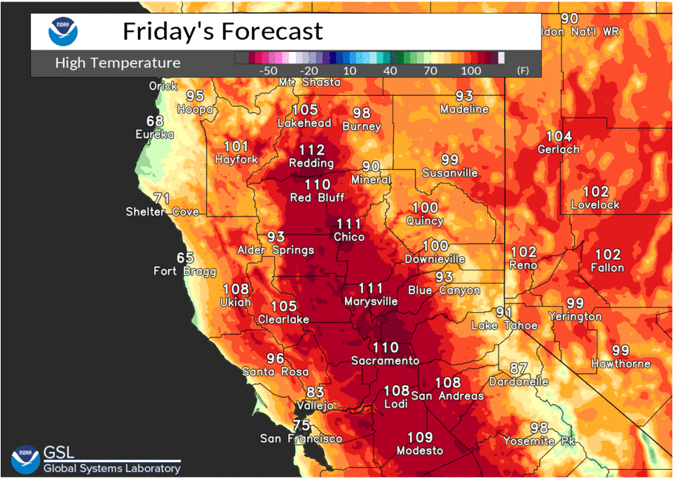
Records are expected to fall again today with all previous records on this date all occurring in 2017. The current records are as follows, Redding 110, Red Bluff 111, Downtown Sac 106, Sac Exec 106, Stockton 108, Modesto 106.

A strong thermal belt will continue tonight keeping some of the warmer foothill locations very warm tonight only cooling off into the mid 70s to lower 80s. The rest of the lower elevations will cool off into the mid 60s to mid 70s with the Delta cooling into the lower 60s.
A slightly stronger Delta breeze tonight may help to cool some inland areas on Saturday around the Sacramento region but the amount will still be limited with highs cooling to around 105 degrees. Saturday night will have slightly better flow through the Delta and a better formation of the stratus should occur along the coast bu Sunday morning.
Sunday a low forms off the coast that is forecast to bring some cooling to the interior the amount as always this time of year depends on how close to the Delta you are. The marine layer may make a greater presence along the coast by then to help cool parts of the interior as well with the downward trend in temperatures expected to continue. Flow through the Delta should be stronger throughout the day.
Sunday night the Delta breeze will become moderate to strong as the low shifts closer to the coast and should help to deepen the marine layer as well as breakdown the strong high pressure over the region. This will lead to places well inland having noticeably cooler temperatures for Monday as well as a greater presence for the coastal areas with low clouds.
Extended discussion (Tuesday through Friday)
Upper low off the CA coast Tuesday is progged to move inland and weaken by GFS. However, EC and ensembles support the low remaining quasi-stationary off the NW CA coast through Friday. This will help to regulate daytime temperatures with highs forecast to be near midweek, to about 4 to 8 degrees above normal by Friday.
Models hint at some afternoon deep moist convection possible in the Coastal Range and Shasta mountains next week, but keep activity just outside our CWA. Forecast remains dry for now but will continue to monitor future model runs.