Local news provides trustworthy information about what’s happening in your community.
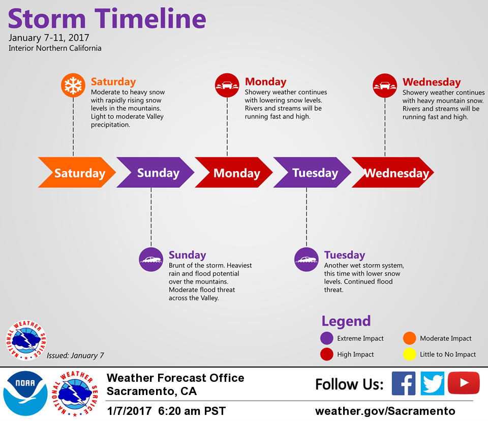
January 7, 2017 – Light to moderate precipitation with snow levels down to the northern Sacramento Valley in the morning, rapidly rising in the afternoon.
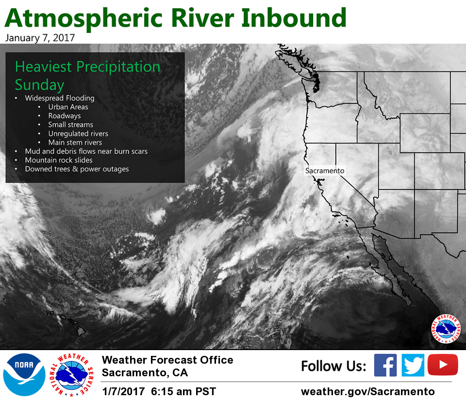
Very heavy rain and flooding concerns arrive Sunday into Monday.
Another wet storm Tuesday into Wednesday with continued flooding concerns and significant mountain snow.
Flood Watch from 4 PM this afternoon through Wednesday afternoon.
Precipitation begins Saturday morning and continues through Monday
heaviest Sunday, intensity will decrease Monday, but there may not be much of a break before the Tuesday storm
streams and creeks that are free-flowing (no dams) will bear close watching; we could see impacts in those areas unseen for years
additional rises expected from Tuesday’s storm
Snow levels
~500 feet northern mountains (including Redding) and 4000-5000 feet in the Sierra this morning expected to rise above 8000 feet this evening
drop back below pass levels early Monday
Winds
Valley gusts 30-45 mph
Mountain ridgetop gusts 45 to 60 mph, locally higher over ridgetops
Wet pattern continues past Monday
Another wet storm system Tuesday–Wednesday, this time with slightly lower snow levels. Another storm expected by the end of the week.
Continued flood threat.
Discussion
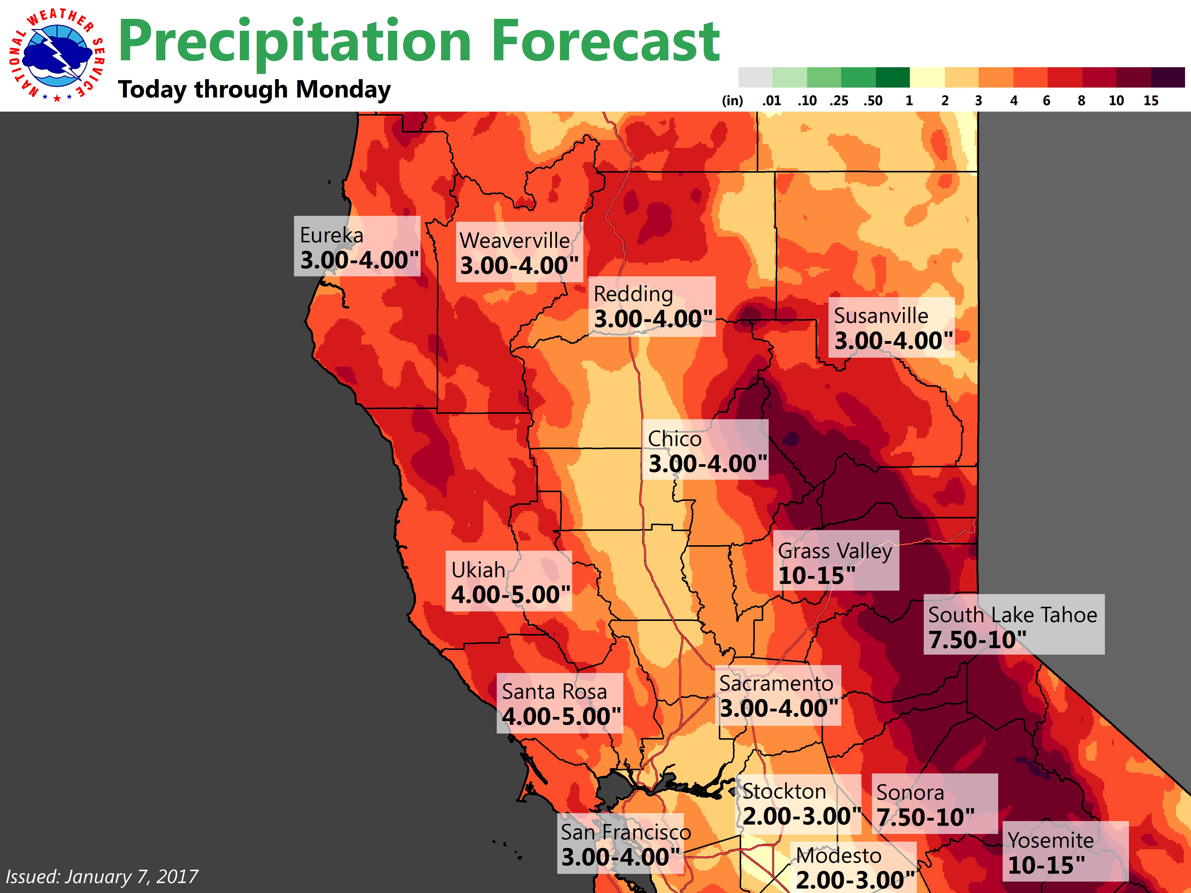
Moderate precipitation has spread across the forecast area. Rain amounts so far are generally around a third to three quarters of an inch. Valley rains will decrease in intensity this afternoon, then increase again this evening and overnight. Heaviest rain is expected during the day Sunday. Snow levels in the Sierra are rising, with snow falling down to 4000 feet, and reported to be already rising to round 6000 feet.
Northerly winds in Shasta County have brought cold air drainage and along with evaporative cooling have brought low snow levels this morning. A mix of wet rain and snow briefly reached as low as Red Bluff, around 350 feet, with some snow accumulating on the grass around Cottonwood (elevation 420 feet). Moderate accumulating snow is falling in around Redding. Snow will continue through the morning, with snow levels rising rapidly this afternoon. A Winter Weather Advisory remains effect, and will be updated to expand the area southward.
Gusty winds have remained mainly over the northern San Joaquin Valley this morning, with sustained winds up to around 26 mph at Stockton at 8 am. Winds gusting to 20 mph at Mather, while Sacramento Executive and International Airports have remained calm. Will likely cancel the wind advisory later this morning. Stronger winds are expected Sunday.
Extended discussion (Wednesday through Saturday)
Westerly flow aloft will continue to bring moisture through northern California going into the extended period. Model agreement starts to fade but there is a general agreement in this westerly flow and orographics should ensure at least moderate precipitation over the Sierra. Temperatures should come in around normal for this time of year.
Models really begin to diverge by next Thursday. ECMWF digs a low in over northern California while GEM puts upper ridging over the Great Basin. GFS keeps a more zonal flow over the region. Any of these solutions could allow for continued precipitation over the CWA but only the ECMWF could bring a continuation of the heavier precipitation that is expected earlier in the week. More amplified ECMWF solution would bring a break in precipitation threat Friday while GFS and GEM continue to feed moisture into the north state. Chance pops continue to be best bet at this time. Although wet pattern may continue into next weekend, at this time models are hinting at at least a reduction in precipitation amounts. Snow levels remain moderate through the extended period.
One reply on “Atmospheric river inbound, heaviest rain on Sunday”
Get the best of YubaNet directly in your email inbox.
Sending to:
Gift this article
Manage Cookie Consent
To provide the best experiences, we use technologies like cookies to store and/or access device information. Consenting to these technologies will allow us to process data such as browsing behavior or unique IDs on this site. Not consenting or withdrawing consent, may adversely affect certain features and functions.
Functional
Always active
The technical storage or access is strictly necessary for the legitimate purpose of enabling the use of a specific service explicitly requested by the subscriber or user, or for the sole purpose of carrying out the transmission of a communication over an electronic communications network.
Preferences
The technical storage or access is necessary for the legitimate purpose of storing preferences that are not requested by the subscriber or user.
Statistics
The technical storage or access that is used exclusively for statistical purposes.The technical storage or access that is used exclusively for anonymous statistical purposes. Without a subpoena, voluntary compliance on the part of your Internet Service Provider, or additional records from a third party, information stored or retrieved for this purpose alone cannot usually be used to identify you.
Marketing
The technical storage or access is required to create user profiles to send advertising, or to track the user on a website or across several websites for similar marketing purposes.