
Happening Now brings you community news, updates and announcements throughout the day.
Send your photos and updates to 530-478-9600.
October 16, 2026 at 3:22 PM PG&E has announced a restoration time of 5:00 pm for the San Juan Ridge, 4:30 for Colfax. The little town of Washington was supposed to be restored by now, updated restoration time is not available. Quelle surprise.
October 16, 2026 at 2:05 PM Here are the forecast notes from the NWS Sacramento dayshift:

- The Red Flag Warning was allowed to expire at 10 AM this morning; however elevated fire weather conditions will continue in the Sierra and adjacent foothills through Saturday
- Wind gusts will gradually weaken through the afternoon and evening, humidity values will continue to be in the single digits/low teens to 20s with poor overnight recoveries tonight
- Elevated Fire Weather conditions will continue in the Sacramento Valley through Saturday as well, with breezy north winds and low daytime humidity values
- Strongest winds along and west of the I-5 corridor; single digit to low teens RH values are being observed and continue Saturday
- High temperatures above normal today, slight cooling Saturday, then Sunday noticeable pattern change begins
- Onshore flow will return, helping humidity recoveries and lowering high temperatures early next week through at least the middle of next week
- Still some uncertainty on precipitation impacts and totals, best probabilities of rain in the foothills and mountains Tue-Wed along with 40-60% chances of 4″ of snow above 8000 feet

October 16, 2026 at 9:26 AM Accident on the 18000 block of Dog Bar Road, vehicle into power pole. Car is in a field, power pole has snapped. Units at scene.
October 16, 2026 at 8:33 AM Via PIO Daniel Ramey.

October 16, 2026 at 7:27 AM Solo accident or abandoned vehicle on Hwy 174 just east of Brunswick Dr.
October 16, 2026 at 6:48 AM Reported accident on McCourtney Road just north of Retrac Way, units dispatched.
October 16, 2026 at 6:24 AM The latest map with the Public Safety Power Shutoff(PSPS) areas for Oct, 16. Data Source: PG&E.
October 15, 2026 at 1:32 PM Broad IC is releasing the last engine, no source of the smell found.
October 15, 2026 at 1:30 PM Firefighters are still attempting to locate the origin of the burning smell, nothing found so far. Broad IC is releasing all units except one engine. The roadway is opening shortly.
October 15, 2026 at 12:36 PM Firefighters are attempting to locate the source of a burning smell in a hotel on Broad Street in Nevada City.
October 15, 2026 at 12:30 PM BriarPatch held their 50th Anniversary Time Capsule Burial Ceremony today. Inside the capsule are a few trinkets, marketing/swag items, and surveys filled out by their staff predicting what the world will be like in 2051 when they reopen the capsule.

October 15, 2026 at 12:00 PM Non-injury accident on You Bet Rd near Hwy 174, the roadway is clear.
October 15, 2026 at 10:53 AM Firefighters have located a small smoldering camp fire near Hughes Road, they can handle with units at scene.
October 15, 2026 at 10:47 AM Firefighters and law enforcement are responding to an incident on the Litton Trail near Hughes and Sierra College in Grass Valley.
October 15, 2026 at 9:55 AM Tree leaning over the roadway just east of Pleasant Valley Road.
October 15, 2026 at 9:03 AM Judging by your email and texts, both the PSPS and the weather forecast calling for gusty winds are not quite “aligned with reality” on the ground.
October 15, 2026 at 7:32 AM NWS Sacramento update:
- Dry and above normal temperatures through the weekend, with Minor HeatRisk
- Pattern change expected early next week, bringing cooler temperatures and potential unsettled weather to the area

October 15, 2026 at 6:33 AM An update by PG&E: Approximately 90,000 customers across 29 counties are in scope for this PSPS event. Customers in scope have received multiple notifications about the event.
As of 6 a.m. Thursday, here are the number of customers who have had their power shut off for safety, by county:
| ALAMEDA | 88 |
| ALPINE | 68 |
| AMADOR | 4776 |
| BUTTE | 3675 |
| CALAVERAS | 10281 |
| CONTRA COSTA | 1358 |
| EL DORADO | 8529 |
| LAKE | 4115 |
| LASSEN | 107 |
| MARIPOSA | 311 |
| MENDOCINO | 444 |
| NAPA | 3158 |
| NEVADA | 1608 |
| PLACER | 4255 |
| PLUMAS | 610 |
| SAN LUIS OBISPO | 2209 |
| SAN MATEO | 1534 |
| SANTA BARBARA | 25 |
| SHASTA | 1484 |
| SIERRA | 1109 |
| SOLANO | 51 |
| SONOMA | 2169 |
| TEHAMA | 905 |
| TUOLUMNE | 8182 |
| YOLO | 7 |
| YUBA | 668 |
| Grand Total | 61730 |
Additional power shutoffs will occur this morning and again tomorrow morning.
October 15, 2026 at 5:54 AM The latest PSPS map by PG&E shows no overnight changes in our area.
October 14, 2026 at 8:52 PM North San Juan, the San Juan Ridge, Washington, the Hwy 20 corridor east of Nevada City and the I-80 corridor from Emigrant Gap have been de-energized by PG&E.
October 14, 2026 at 3:57 PM Yuba County Sheriff’s Office: On Wednesday, Oct. 14 at approximately 1:45 p.m., the YCSO received a report of a potential bomb threat at the Walmart Supercenter on North Beale Road in Marysville. Prior to YCSO deputies arriving, Walmart had evacuated the building per its policy. Deputies conducted an extensive sweep of the premises and did not find anything suspicious. The store has been reopened and resumed business as usual
October 14, 2026 at 2:26 PM Red Flag Warning and potential Public Safety Power Shutoff (PSPS). PG&E will notify customers again within four hours of their planned power shutoff.

October 14, 2026 at 1:25 PM Tankers have launched to a fire in Woodleaf, Yuba County, near the Butte county line.
October 14, 2026 at 11:35 AM Red Flag Warning for the Sierra and adjacent foothills, in effect beginning at 12 AM Thursday, October 15th through 10 AM Friday, October 16th, 2026.

- East to northeast winds of 15-25 mph sustained; gusts 25-45 mph
- Potential for locally higher gusts at peaks and gap wind prone areas
- Strongest winds expected above 3000 feet
- Daytime humidity values 10-25% with single digits possible; very poor overnight recoveries
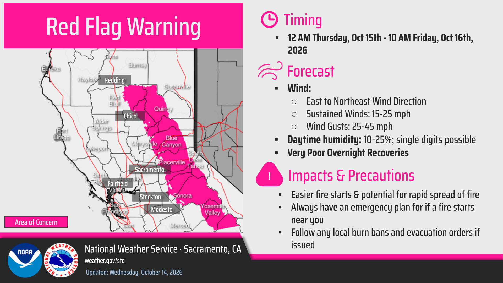
October 14, 2026 at 10:33 AM The National Weather Service in Sacramento has issued a Red Flag Warning from midnight tonight to 10:00 am on Friday.
October 14, 2026 at 8:51 AM The shelter has so many kittens available for adoption. The cat distribution system has a bottleneck, can you help?

October 14, 2026 at 6:24 AM The latest map for PG&E’s potential Public Safety Power Shutoff (PSPS) event.
October 14, 2026 at 6:17 AM NWS Forecast Update: With the latest forecast package the winds have trended slightly lower for today, and slightly higher for Thursday-Friday. Humidity continues to be low each day with locally poor overnight recoveries. Elevated fire weather conditions continue today through Friday, with less winds today and the main period of concern being Thursday into Friday where winds increase and bring elevated to near critical conditions. Strongest winds are expected in the Sacramento Valley, over higher terrain and in any aligned gaps/canyons. Temperatures warm for the rest of the week and remain above normal through the weekend, with mainly Minor HeatRisk. Cooler temperatures and shower chances return to the forecast early next week.

October 14, 2026 at 6:00 AM Updates on the Chalk fire will be posted on the Chalk incident page, no significant growth expected.
October 14, 2026 at 5:46 AM Dozer is responding to the Chalk incident.

October 14, 2026 at 5:35 AM Firefighters are responding to the Chalk incident on Red Hill Spring Rd off Chalk Bluff Road.
October 13, 2026 at 6:52 PM Units are at scene on Crawford Ln, homeowner is extinguishing the pile with their help. One engine to continue in, all others can cancel
October 13, 2026 at 6:43 PM Burn pile on Crawford Ln near Meadow Drive and Hwy 174 in Peardale, units dispatched.
October 13, 2026 at 5:03 PM This is the latest map of PG&E’s potential Public Safety Power Shutoff (PSPS) event.
October 13, 2026 at 4:47 PM The Ready incident is fully contained at 0.7 acres.
October 13, 2026 at 3:10 PM Canceling all incoming engines, can handle with units at scene. Prevention officer responding.
October 13, 2026 at 2:49 AM Reported small spot on Hwy 20 and Rough & Ready Hwy, full wildland dispatch on order.
October 13, 2026 at 11:49 AM Prescribed burn underway off Excelsior Ditch Road outside of Nevada City, slated for 10 acres. Smoke is visible in Nevada City and surrounding areas.

October 13, 2026 at 11:39 AM Another Fall photo, this time by reader George. Maple leaves galore.

October 13, 2026 at 9:25 AM The planned prescribed fire at the Nevada County Airport is canceled due to forecasted fire weather conditions.
October 13, 2026 at 7:57 AM Non-injury accident on Brunswick Rd at Greenhorn. The roadway is clear.
October 13, 2026 at 6:17 AM Overnight, PG&E has issued a two-day warning about a potential Public Safety Power Shutoff in 22 counties. In our area, the higher elevations are affected – a few hundred customers in Nevada, Placer and Yuba counties are affected. A large majority of Sierra County is in the warning zone.
October 13, 2026 at 5:48 AM The NWS Sacramento forecast:

The showers from yesterday have tapered off and warming and drying weather returns to the region the rest of the week. High temperatures will trend just a few degrees below normal today, before rising to above normal late in the week.
Low humidity will combine with periods of breezy north to east winds today through Friday.

This will lead to elevated fire weather conditions at times in the Valley, foothills and mountains this week. There is potential for a pattern change early next week to cooler temperatures and some shower chances.
October 12, 2026 at 5:53 PM Car blocking the roadway on southbound Hwy 49 at Old Downieville Hwy in Nevada City.
October 12, 2026 at 4:51 PM Let’s find Flora her forever home.

October 12, 2026 at 12:03 PM Units are at scene of the reported vegetation fire on Manzanita Jungle Dr, two engies to continue in, all others can cancel.
October 12, 2026 at 11:49 AM Reported vegetation fire on Manzanita Jungle Drive across of South Ponderosa Drive in Grass Valley. 20 by 20 spot approximately 100 ft from a residence. Locals are trying to extinguish, units dispatched.
October 12, 2026 at 11:48 AM Accident on Hwy 49 between North San Juan and Moonshine Road, units dispatched for the rear end of a vehicle jsut visible from the roadway.
October 12, 2026 at 11:16 AM Non-injury accident on Wheeler Cross Rd and Rattlesnake. Solo motorcycle, moved out os the roadway.
October 12, 2026 at 11:07 AM Reader Doug in Nevada City shares the Fall colors, all of them.

October 12, 2026 at 10:03 AM Another homeowner starting aburn pile on Peoria Rd near Bald Mountain Rd. The burn ban is still in effect and for good reasons!
October 12, 2026 at 7:44 AM Incoming engines to the McKitrick Ranch incident to stage at Owl Creek and Jones Bar, NCSO to respond as well.
October 12, 2026 at 7:36 AM Debris check for a broadcast burn on McKitrick Ranch Road in the Jones Bar area, the usual suspect is at it again. Units dispatched.
October 12, 2026 at 6:28 AM Here is the latest update to the NWS Sacramento forecast:

Fire Weather Concerns:
- Winds continue to diminish slowly this morning, with RH values in 20s across the northern Sacramento Valley and adjacent foothills. RFW was allowed to expire at 5am this morning as we will see continued improvements throughout the day.
- Elevated Fire Weather Concerns return Tuesday as breezy northerly winds combine with low RH in the teens across the Sacramento Valley and northern San Joaquin Valley.
- Potential for further elevated fire weather concerns in the Valley and mountains Wednesday through Friday.
Wind:
- Winds will continue to diminish slowly this morning, but we could still see gusts up to 30mph in parts of the northern Sacramento Valley and adjacent foothills through the morning and into the early afternoon.
- Elsewhere, winds would have the potential to gust up to 20mph.
Precipitation/Snow
- We will see continued chances for rain, storms, and snow through today for the Sierra.
- There is a slight chance (less than 10%) for a stray shower or potential storm within the southern Sacramento Valley towards northern San Joaquin Valley this morning and again in the late afternoon/evening.
- Possibility for an isolated stronger storm with brief heavier rain, lightning, and small hail (Best chance within the mountains).
- First measurable snowfall is likely within the Sierra especially along and south of Highway 50.
Temperatures:
- We will continue to see below normal temperatures through mid week, with a warm up to seasonal averages end of the week and into the weekend.


October 12, 2026 at 6:20 AM Be advised the all Nevada County Transit services will be closed on Monday, October 12 in observance of the Columbus Day holiday.
October 11, 2026 at 6:47 PM Motorcycle down after an accident on Indian Springs Road, air ambulance on order.
October 11, 2026 at 4:25 PM Non-injury accident on the 11000 block of Red Dog Road. The roadway is partially blocked.
October 11, 2026 at 3:34 PM Updates on the Rock fire will be posted on the Rock Creek incident page.
October 11, 2026 at 3:28 PM Two helicopters are working the Rock incident, focusing on the spot fires.
October 11, 2026 at 3:24 PM Tankers are building a contingency box around the perimeter to catch any new spot fires. The Rock fire is estimated at 2 acres.
October 11, 2026 at 3:15 PM AIr Attack states dozers are needed to make access to the fire. Rock IC is requesting two dozers, four water tenders and five engines.

October 11, 2026 at 3:08 PM Engines to stage on Rector and Rock Creek.
October 11, 2026 at 3:07 PM The fire is located on Rock Creek and Running Horse, some spot fires across the retardant line. Winds are out of the southeast.
October 11, 2026 at 3:05 PM Helicopter 514 is on approach, they can set down for the crew at the heel of the fire.

October 11, 2026 at 3:04 PM Air Attack reports the fire is transitioning from grass to brush, no structures threatened.
October 11, 2026 at 3:01 PM Air Attack reports less than 1/4 acre, tanker will drop across the head.
October 11, 2026 at 3:00 PM Reported vegetation fire on Rock Creek Road, units dispatched. Aircraft have lifted for the Rock incident near Rock Creek Rd and Rector Rd outside of Nevada City.
October 11, 2026 at 8:09 AM Reader Joel captured some of the runners participating in the Champion Mine Trail Race as they were coming down near American Hill.
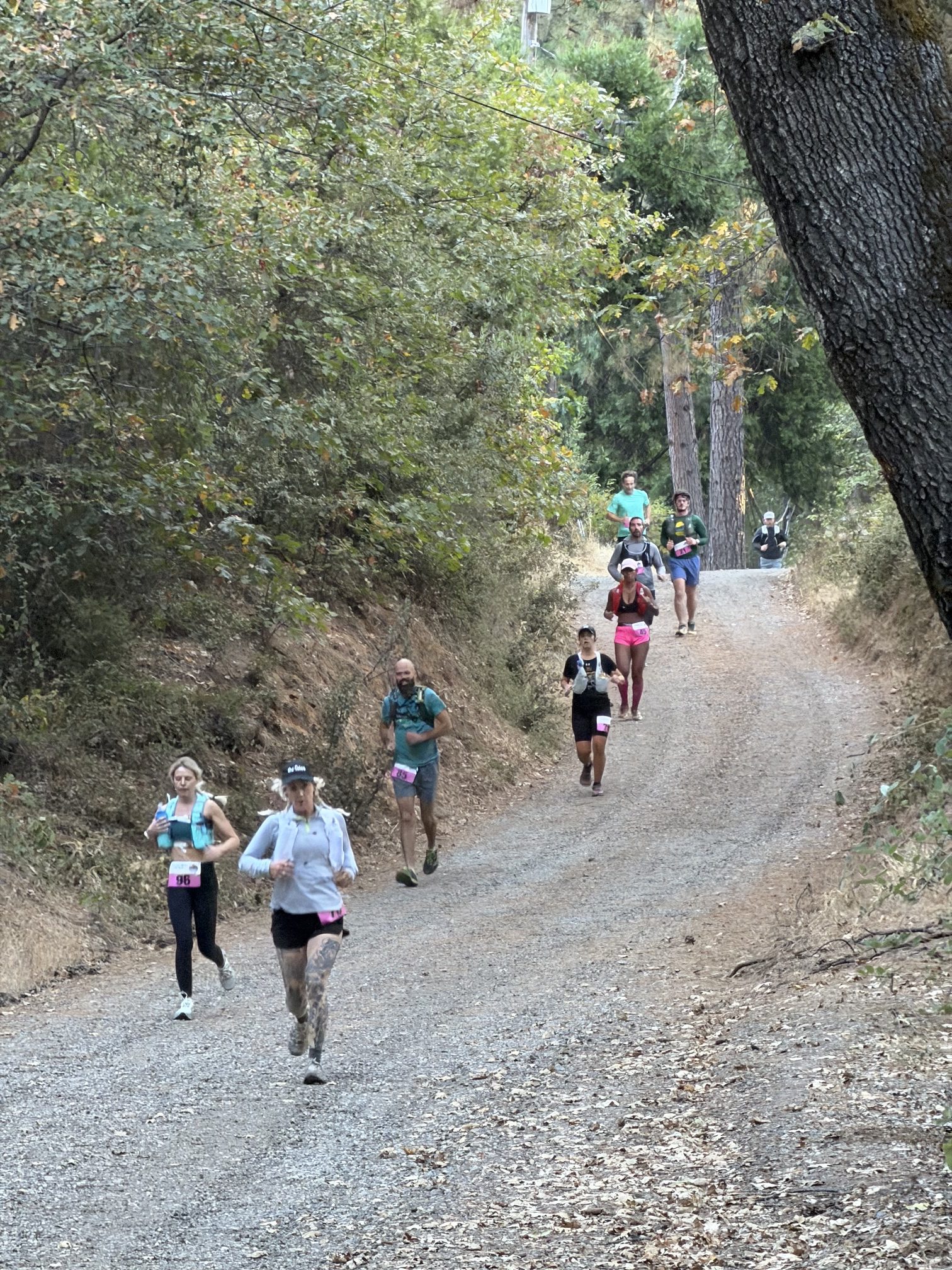
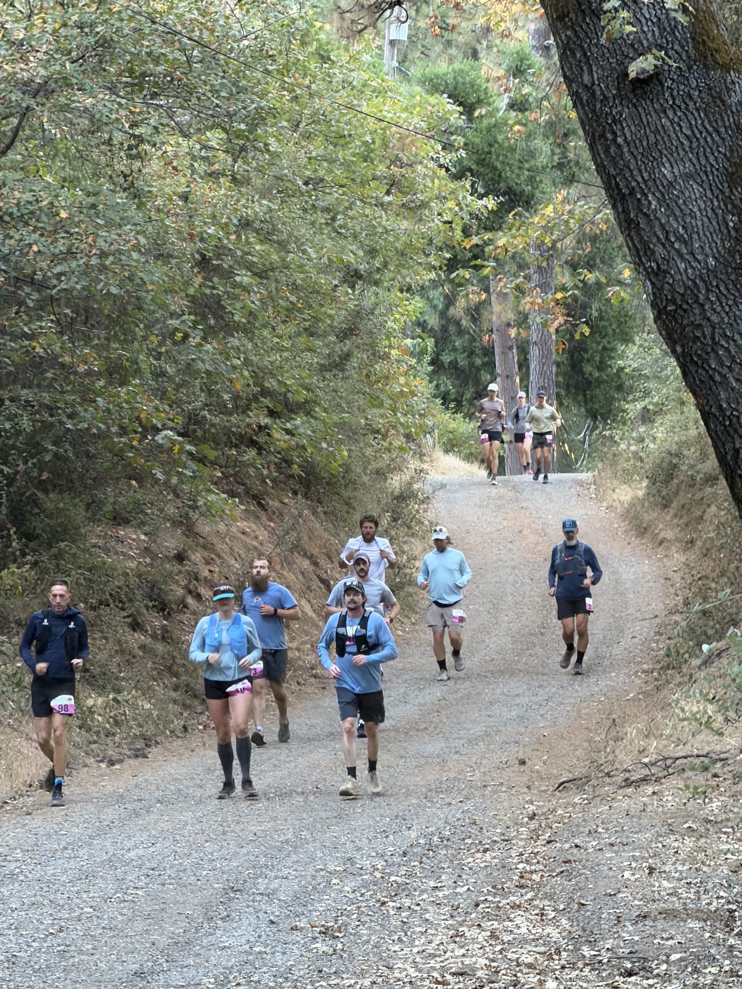
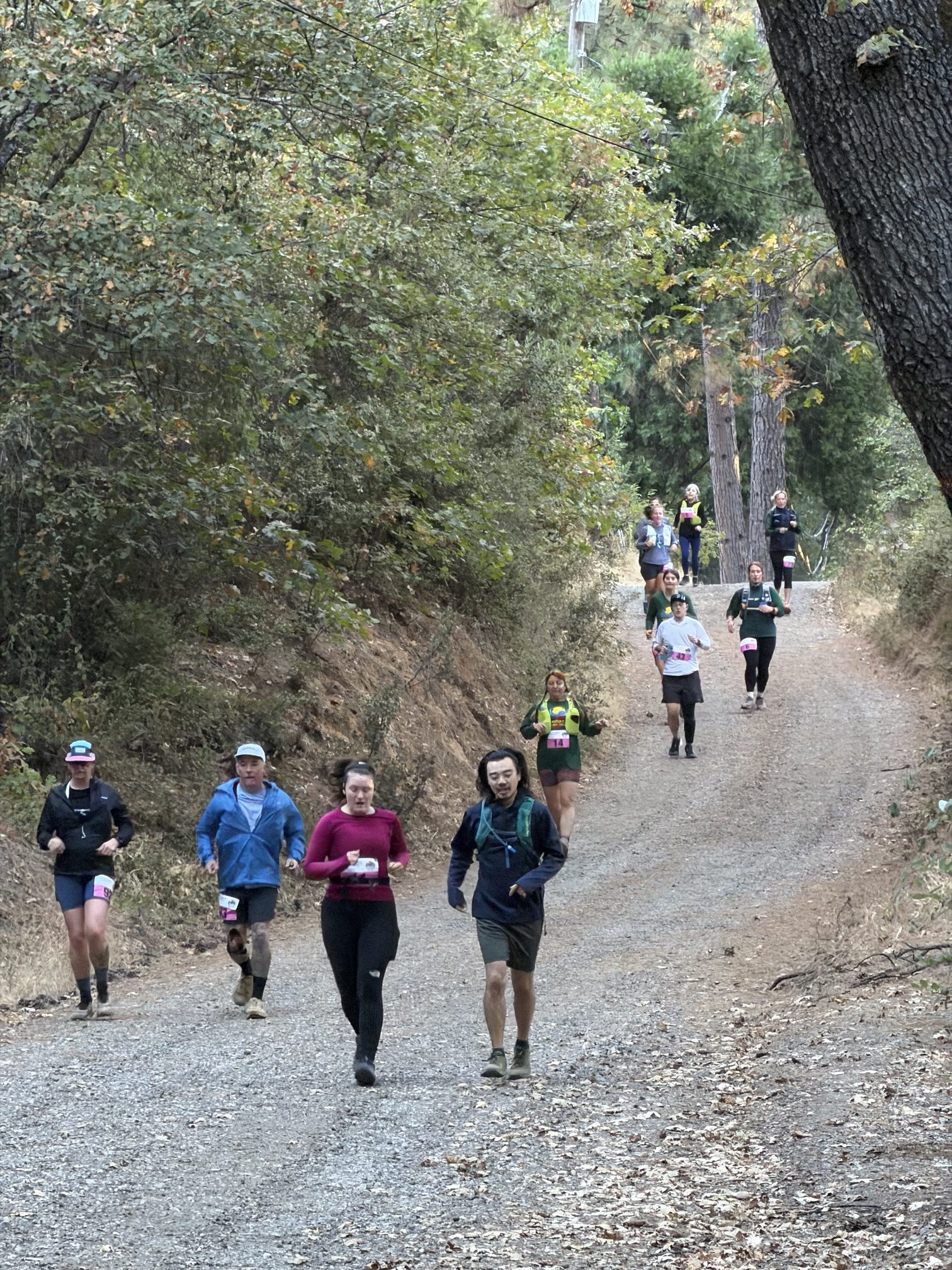
October 11, 2026 at 6:46 AM The Bear Yuba Land Trust along with the Sierra Trailblazers Running Club are hosting the second annual Champion Mine Trail Race. Starting and ending at the Miners Foundry in downtown Nevada City, the Race takes runners up Broad Street before heading out along American Hill, Old Downieville, Champion Mine, and the Deer Creek Tribute Trail System.
Please expect runners on the course from 7:30am until roughly 12pm. No roads or trails will be closed.
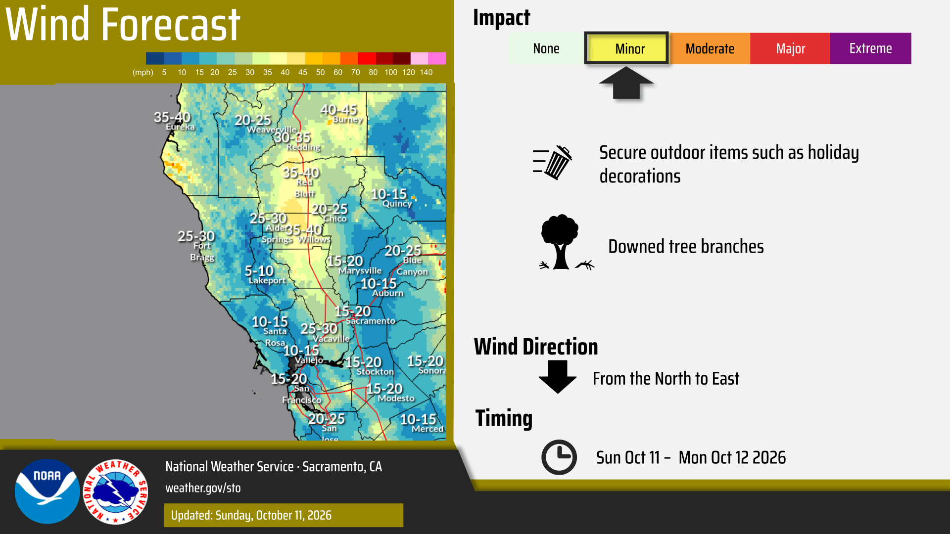
October 11, 2026 at 6:43 AM The NWS Sacramento forecast updates:

- Critical Fire Weather Conditions today for the Northern Sacramento Valley and adjacent foothills for the combination of low RH and gusty north winds today into Monday.
- Red Flag Warning goes into effect at 7am today and continues through 5am Monday.
- Gusty north to northeast winds of 20-30mph, and gusts of 30-40mph locally higher in the northern Sacramento Valley and adjacent foothills. Best chances will be along and west of I-5.
- Elsewhere southerly wind gusts up to 30mph expected, with the strongest south of Sacramento.
- Confidence continues to be on the higher side for the first measurable snow in the Sierra today through Tuesday morning.
- Snow levels around 7000 feet this morning lower to 6500 feet tonight. Further lowering to 6000 feet Monday through Tuesday.
- Best chances will be along and south of Highway 50 in the Sierra at the highest peaks.
- Mountain showers/isolated thunderstorms today through Tuesday morning, with the best chances along and south I-80.
- Thunderstorm chances have decreased slightly, but remain around 10% for the Sierra.
- Temperatures will continue to be below normal through mid week, but return to seasonal averages end of the week and into next weekend.
- Potential for elevated fire weather conditions within Mountains Thursday and Friday as winds have trended upward and RH values downward.

October 10, 2026 at 6:43 PM On closer inspection, it was a cooking fire on Cruzon. All units canceled.
October 10, 2026 at 6:29 PM Solo vehicle accident, car into a ditch, on Lime Kiln Rd at Bald Hill Rd.
October 10, 2026 at 6:12 PM Units at scene on Cruzon Grade report one already extinguished debris pile.
October 10, 2026 at 6:09 PM Debris check on Cruzon Grade near Fox Fire Way on the San Juan Ridge. Units dispatched.
October 10, 2026 at 5:27 PM Reader Karen captured this perfect picture of a female praying mantis, a surefire sign of fall.

October 10, 2026 at 12:51 PM The beauty of Fall colors – maple leaf. Submitted by reader Kate D.

October 10, 2026 at 9:28 AM If you encounter great fall colors, or Halloween decorations, send a photo our way. Happy to feature them.
October 10, 2026 at 7:55 AM The daily weather forecast from NWS Sacramento. Data NWS Sacramento, video generated with Claude.

October 9, 2026 at 11:32 PM Utility power has been restored in the outage area except for 163 customers on Joerschke Drive.
October 9, 2026 at 11:21 PM Partial power restoration is underway in the Newtown and Ridge Road areas.
October 9, 2026 at 10:55 PM Estimated time of restoration for this massive outage is 4:00 am.
October 9, 2026 at 10:50 PM Trouble crews are at the outage, several large circuits are down with no estimate of restoration yet.
October 9, 2026 at 10:39 PM Outage possibly caused by a vehicle into a pole. Power lines are down.
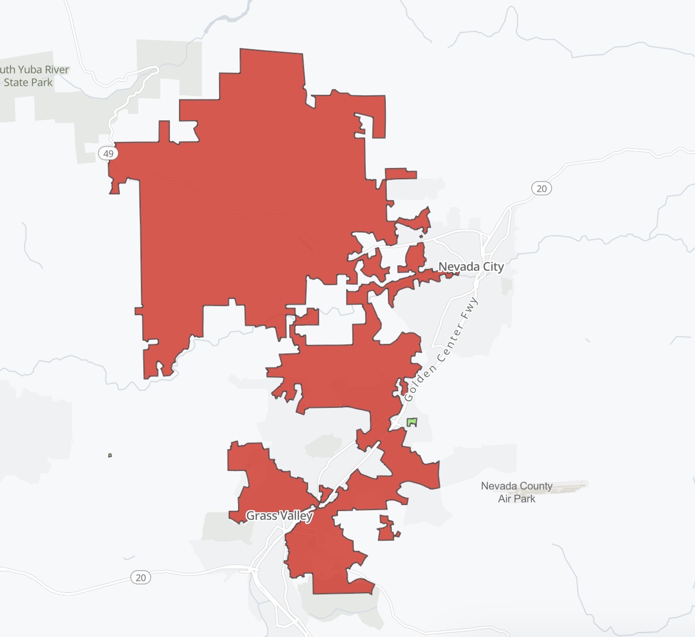
October 9, 2026 at 10:38 PM Initial info 5,388 PG&E customers are out of power in Grass Valley. Map coming shortly.
October 9, 2026 at 10:34 PM Power outage in Grass Valley, no update on reach from PG&E yet.
October 9, 2026 at 9:37 PM Firefighters at scene of a trash barrel on Oak Tree can handle, canceling all incoming units.
October 9, 2026 at 9:36 PM Firefighters have located a fire, they are walking in to the incident. All incoming units to take a right at the post office.
October 9, 2026 at 9:29 PM Firefighters are attempting to locate the reported fire.
October 9, 2026 at 9:25 PM NSJ firefighters arriving at scene of the Oak incident.
October 9, 2026 at 9:22 PM Reported vegetation fire on Hwy 49 and near Oak Tree Rd in North San Juan. Single report from a passerby, numerous units dispatched.
October 9, 2026 at 7:39 PM Readers confirm utility power has ben restored in Lake Wilwood, Rough and Ready and Big Oak Valley.
October 9, 2026 at 7:36 PM PG&E has deemed the pole safe, per firefighters at scene, utility power should be restored momentarily.
October 9, 2026 at 7:34 PM The power outage count is now up to 4,124.
October 9, 2026 at 7:18 PM The outage in Penn Valley is affecting 3,914 PG&E customers. Including Rough and Ready, Lake Wildwood and Big Oak Valley.

October 9, 2026 at 7:12 PM The arcing transformer on Penn Valley Dr has led to power being turned off in the area. Waiting for the extent of the outage.
October 9, 2026 at 7:07 PM Transformer reported on fire on Penn Valley Dr across from Easy Street. Units dispatched.
October 9, 2026 at 6:29 PM Overturned car in a ditch on Dog Bar Road near Wheeler Acres. Units dispatched.
October 9, 2026 at 3:52 PM A wrong way driver on southbound Hwy 49 at McKnight Way poses a hazard for other drivers and themselves. The “Do not Enter” and “Wrong Way” signs are not just suggestions.
October 9, 2026 at 3:10 PM Plan the weekend and the rest of the month with our Calendar. Add your events too, this is a real human-powered calendar.

October 9, 2026 at 1:39 PM Non-injury accident on Hwy 49 at Alta Sierra Drive. The roadway is clear.
October 9, 2026 at 11:21 AM Marysville IC reports hoselines are tied in, forward progress has been stopped.

October 9, 2026 at 11:19 AM Air Attack releases the helicopter and both tankers, IC requests one crew and one water tender to continue in, all others can cancel.
October 9, 2026 at 11:17 AM Marysville Air Attack estimates the fire at 1 to 1.5 acres, crews are making access all around the fire. IC states the crews are making good progress.
October 9, 2026 at 11:11 AM First unit at scene reports a roadside spot, approximately 1/2 acre. The fire is burning uphill and a residence on top of the hill is potentially threatened. Aircraft is arriving over the Marysville incident.
October 9, 2026 at 11:05 AM Leahs Way/Marysville incident now visible on the cameras.

October 9, 2026 at 11:02 AM Reported vegetation fire, full wildland dispatch in Yua County near Collins Lake on Leahs Wy and Marysville Road.
October 9, 2026 at 8:52 AM Debris check on Meyer Ravine Rd off Cannon Way in south county, units dispatched.
October 9, 2026 at 8:13 AM Here is the latest update to the NWS Sacramento forecast.

- Above normal temperatures continue today, with highs slightly cooler than yesterday.
- Areas of Moderate HeatRisk in parts of the foothills today
- Periods of gusty onshore winds tonight into Saturday morning, with gusts of 30-40mph within the Delta, and along the Sierra peaks.
- Cooler temperatures are expected Saturday, Sunday and into next week.
- Pattern change over the weekend helps usher in the cooler temperatures, but also brings gusty winds and mainly mountain rain showers/thunderstorms Sunday into Monday.
- Moisture from the remnants of Tropical Storm Rachel will likely remain south of our forecast area.
- Probabilities of seeing 0.50” of precipitation in the mountains is 40-50%, with the best chances along and south of I-80.
- Gusty north to easterly winds Sunday into Monday combined with lower RH in the northern Sacramento Valley and adjacent foothills bring elevated fire weather conditions.
- Uncertainty with the relative humidity and how low it drops as the trough moves through the region.
- Lingering showers in the mountains mid week, with more seasonal temperature.

October 9, 2026 at 6:56 AM Firefighters are winding down operations on the hughes incident.
October 9, 2026 at 6:22 AM Final size is 0.13 acres for the Hughes incident.
October 9, 2026 at 6:19 AM Caller reports a dumpster fire at the Sierra Cinemas location on Hughes Rd, firefighters are still at scene from the Hughes incident and will take action.
October 9, 2026 at 6:10 AM Forward progress of the Hughes fire has been stopped, extensive mop-up operations are starting.
October 9, 2026 at 6:05 AM Firefighters are at scene of a small fire on East Main St in Grass Valley. This will be the Hughes incident.
October 8, 2026 at 4:57 PM Candy corn pumpkin puffer fish by Wendy.

October 8, 2026 at 2:59 PM Jessica Scott has been found safe.
October 8, 2026 at 2:33 PM Smoke coming from a car at the Donner est area on eastbound I-80. Units dispatched.
October 8, 2026 at 1:58 PM Puppies, kittens – and so many of them. If you can, help out Sammie’s Friends by attending their Oct. 16 event.

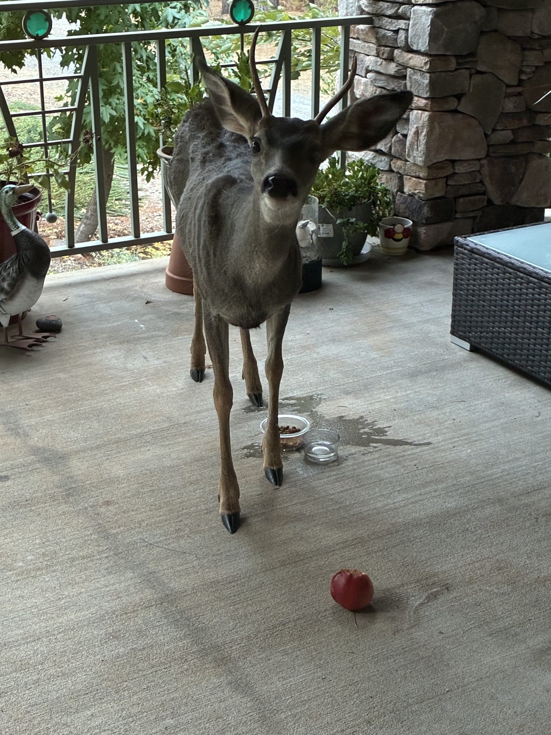
October 8, 2026 at 12:34 PM Reader Mike has a picky eater show up for snacks. Cat food – no, water – maybe, apple – more please.
October 8, 2026 at 10:43 AM Units at scene on Ironclad report smoke showing from a garage. Taking action now.
October 8, 2026 at 10:341 AM Possible structure fire on Ironclad Rd off Rough and Ready Hwy. Units dispatched.
October 8, 2026 at 9:43 AM Small Brindle puppy missing in the Gracie and Banner area. Contact 530-210-5166 with info.

October 8, 2026 at 9:39 AM Wonders never cease. PG&E text about yesterday’s outage in Nevada City. The outage was caused by an animal, according to them.
October 8, 2026 at 9:10 AM Power has been restored to all 851 utility customers in the Peardale/Chicago Park area.
October 8, 2026 at 8:03 AM PG&E’s estimated restoration time, calculated by an obscure formula probably, is 1:15 pm for the peardale/Chicago Park outage.
October 8, 2026 at 7:34 AM Here’s the map of PG&E’s latest outage.

October 8, 2026 at 7:26 AM The utility is now confirming 851 customers are out of power in the Hwy 174 corridor.
October 8, 2026 at 7:24 AM Reader-reported power outage in parts of Chicago Park and Peardale. Nothing showing on the PG&E map.
October 8, 2026 at 6:43 AM Here is the latest update to the NWS Sacramento forecast:
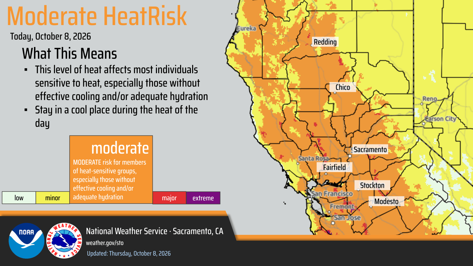
- Heat Advisory continues through 10pm tonight, with Moderate HeatRisk expected across the Valley, Foothills, and Delta.
- Temperatures will continue to be above average Friday, with highs in the 90s.
- Temperatures cool over the weekend and into next week, with at or below average highs.
- Trough moves through the western United States Sunday through Monday bringing the potential for unsettled weather to California.
- Uncertainty with precipitation timing and amounts.
- Probabilities of seeing over a half inch of precipitation or greater Sunday through Monday is 30-50% over the Sierra, with the best chances along and south of I-80.
- 10-15% chance for thunder Sunday over the Sierra.
- Gusty onshore winds Friday into Saturday, with gusts 35-45 mph within the Delta and over the Sierra Crest.
- Potential to see Elevated Fire Weather Concerns Sunday into Monday for the northern Sacramento Valley and adjacent foothills.
- This is due in part to breezy north to easterly winds of 25-35mph combined with low relative humidity.
- Uncertainty on the strength of the wind gusts and how low humidity gets.
October 8, 2026 at 6:33 AM Low-hanging wire over the roadway on the 13000 block of Dog Bar Rd. Utilities notified.
October 7, 2026 at 9:58 PM Forward progress stopped on both fires. Mop-up operations will take about two hours.
October 7, 2026 at 9:52 PM Firefighters have knockdown on one of the Hwy 20 fires, working on the second one.
October 7, 2026 at 9:45 PM The eastbound lane of Hwy 20 is being shut down in the area of the fire.
October 7, 2026 at 9:44 PM CHP requested to provide traffic control on Hwy 20.
October 7, 2026 at 9:41 PM Units at scene report fire on both sides of the highway, 1/8 acre on the north side, 1/4 acre on the south side. Additional units dispatched.
October 7, 2026 at 9:40 PM Reported vegetation fire at Hwy 20 and Rex Reservoir Rd, 20 by 20 spot off the roadside.Units dispatched.
October 7, 2026 at 9:06 PM Magra IC reports they can handle with resources at scene.
October 7, 2026 at 9:01 PM Units at scene on westbound I-80 justwest of Magra report a 50 by 50 spot on the downhill side.
October 7, 2026 at 8:56 PM Reported vegetation fire on westbound I-80 near the Rollins Lake Rd off ramp. Units dispatched.
October 7, 2026 at 4:58 PM Trades Day at the Fairgrounds was a success. Check out the cool equipment the students got to use.

October 7, 2026 at 4:44 PM Nevada County Connects: Please be advised that due to resource issues, route 1B (8:30 AM – 4:30 PM) is cancelled from Thursday, October 8th through Friday, October 16th. We apologize for this disruption. Route 1A (7:00 AM – 8:00 PM) is still running.
October 7, 2026 at 2:02 PM Forward progress on the Riosa incident has been stoped at 30-35 acres. Air Attack is releasing all the tankers.
October 7, 2026 at 1:55 PM Riosa incident is approximately 5 acres in grass, tankers have dropped on the head of the fire. Helicopters are extinguishing hot spots.
October 7, 2026 at 1:35 PM Aircraft and ground resources are at scene of the Riosa incident. No structures threatened.
October 7, 2026 at 1:32 PM Reposting here for visibility.

October 7, 2026 at 1:17 PM Fire is visible on the camera.

October 7, 2026 at 1:13 PM Reported vegetation fire on Riosa Rd in Placer County, approximately 2 acres in a field. Full wildland dispatch on order.
October 7, 2026 at 12:53 PM The vehicle fire on Hwy 49 at Lime Kiln is fully extinguished. IC Requesting a tow truck for the pickup.
October 7, 2026 at 10:33 AM Power has been restored to all 792 customers who remained out of power since 7:54 am this morning in te Nevada City area.
October 7, 2026 at 10:13 AM Power is reportedly restored in downtown Nevada City.
October 7, 2026 at 9:44 AM Watch Denay Woodman and Michelle Amador as they tell us all about the Open Studios Tour kicking off this weekend.

October 7, 2026 at 9:37 AM Reader report of power restored on Railroad Ave in Nevada City. The outage has been reduced to 1,336 customers.
October 7, 2026 at 9:10 AM Due to a power outage today Wednesday October 7, the Nevada City Courthouse is closed until 1:30pm.
D1 all AM reset for 1:30pm.
D2 all AM reset for a new date.
D3 all AM reset for a new date.
D4 all AM reset for 1:30pm.
D5 all AM reset for a new date.
D6 all AM reset for 1:30pm.
October 7, 2026 at 8:49 AM Madelyn Helling Library will open on schedule at 10:00 am and has power and internet for all patrons.
October 7, 2026 at 8:39 AM First unit at scene on New York Flat Rd reports a 20 by 20 illegal burn pile, they’re extinguishing it now. Canceling incoming resources.
October 7, 2026 at 8:37 AM Now a full wildland dispatch for the fire on New York Flat Rd, no aircraft on order.
October 7, 2026 at 8:35 AM Smoke check in the New York Flat Rd area in Yuba County.

October 7, 2026 at 8:14 AM Estimated restoration time is noon for the Nevada City outage. That’s an automatic estimate, fingers crossed it will be sooner for everyone without a generator, namely the businesses in town.
October 7, 2026 at 8:10 AM Cal Fire is conducting a prescribed burn near Colfax.
October 7, 2026 at 8:06 AM There’s the map. From Banner Lava Cap to B4 Ranch Rd through Nevada City.

October 7, 2026 at 8:04 AM Now we’re part of the 3,476 PG&E customers without utility power.
October 7, 2026 at 8:00 AM We told them the power was out and all we got was a text saying there may be an outage near us. That much we knew already.
October 7, 2026 at 7:54 AM Power outage at YubaNet HQ, generator’s humming. Let’s see what PG&E has to say for themselves.
October 7, 2026 at 7:07 AM Garbage bags in the southbound lane of Auburn Rd at McCourtney are causing drivers to swerve. Didn’t quite make it to the dump, huh?
October 7, 2026 at 6:14 AM Who knew?! Penn Valley Party Poopers at the World Championship Outhouse Races.

October 7, 2026 at 5:51 AM Here are the NWS Sacramento overnight forecast highlights:

- Unseasonably hot temperatures continue this week
- Widespread Moderate HeatRisk and areas Major HeatRisk continue across interior NorCal through Thursday
- Onshore flow now is expected to bring slightly less hot temperatures Friday, with some areas of Moderate HeatRisk
- Heat Advisory continues through 10 PM Friday
- Confidence is trending high in significantly cooler, below normal temperatures this weekend into early next week
- High uncertainty remains regarding showery/unsettled weather this weekend into Monday, especially precipitation amounts.
- Mainly mountain showers currently expected, along with a 10-15% chance of thunderstorms Sunday for Sierra south of I-80.
- Gusty onshore winds are expected Friday night into Saturday, with the Delta Breeze and Sierra Crest winds gusting up to 45 mph.
- Elevated fire weather conditions may develop Sunday and Monday for the Sacramento Valley and adjacent foothills, with north to east wind gusts of 25-35 mph along and west of the I-5 corridor and foothills.
- Uncertainty remains in overall strength of wind gusts and especially how low humidity will get

October 6, 2026 at 6:31 PM Firefighters have knockdown on the Boole incident.
October 6, 2026 at 6:15 PM All aircraft have been released from the Boole incident. Firefighters are making good progress on knockdown.
October 6, 2026 at 6:08 PM First unit at scene reports a fully involved barn/cabin. Air Attack reports no extension to the wildland at this time.
October 6, 2026 at 6:03 PM Air Attack and tankers have lifted to the structure fire. Fire is possibly on the Placer Hills side on Boole Rd.
October 6, 2026 at 5:53 PM Structure fire with threat to the wildland on Cerro Vista Dr in the Foresthill or Placer Hills area. Full wildland dispatch on order.

October 6, 2026 at 3:22 PM Now we know. The Great Candy Corn Debate – Survey Results Are In. Check the story for our surprise contest.

October 6, 2026 at 1:51 PM Long time no post about this. A trailer with horses is stuck on the Placer Hills side of the Dog Bar bridge. CHP at scene, the roadway is blocked.
October 6, 2026 at 12:41 PM Vehicle fire has been knocked down.
October 6, 2026 at 12:30 PM The reported vehicle fire on West Empire is an engine compartment fire according to the caller. First unit is at scene.
October 6, 2026 at 12:27 PM Passenger vehicle fire with threat to the wildland on West Empire St in Grass Valley. Units dispatched.
October 6, 2026 at 8:40 AM Nevada County Connects: Be advised that Route 1B (8:30 AM – 4:30 PM) is temporarily canceled due to bus charging issues. We apologize for any inconvenience this may cause. Route 1A (7:00 AM-8:00 PM) will still run.
October 6, 2026 at 5:58 AM The NWS Sacramento forecast update:

- A Heat Advisory remains in effect through 10 pm Friday for the Delta, Valley, and foothills
- Dry weather with well above normal high temperatures and Moderate/isolated Major HeatRisk continues this week
- Widespread high temperatures in the 90s to lower triple digits Today-Friday
- Continued chances to reach daily high and high minimum temperatures records at several sites
- Cooler temperatures for the weekend, near to below normal highs
- Some potential for showery/unsettled weather for weekend into early next week, but this remains highly uncertain
- Gusty weekend winds, onshore Saturday then shifting to north to east Sunday into Monday, bringing the potential for fire concerns, but humidity levels are currently uncertain.


October 5, 2026 at 7:38 PM All lightning fires and burn piles are either staffed and not growing or contained.
October 5, 2026 at 6:04 PM Firefighters are at scene of a small fire above Lake Wildwood.

October 5, 2026 at 5:30 PM The Bloomfield incident is holding at 1/4 acre. Ground resources are at scene and both air tankers have been released.
October 5, 2026 at 4:20 PM Bloomfield IC has arrived at scene, requesting two hand crews and two dozers. The fire is holding in its current footprint.
October 5, 2026 at 4:17 PM Bloomfield Air Attack is requesting an additional helicopter to the incident due to its remote location.
October 5, 2026 at 3:48 PM Air Attack 230 and tankers are over a small fire on North Bloomfield and Back Bone. Less than 1/4 acre in brush and timber understory. Ground access is off Relief Hill Rd.
October 5, 2026 at 3:31 PM Car somewhat over the embankment on Dog Bar Rd at Magnolia. Missed the driveway.
October 5, 2026 at 3:23 PM The pup lounging at Camp Gold Hollow is being picked up by her human. All is well.
October 5, 2026 at 3:07 PM Smoke check on Back Bone Rd and North Bloomfield on the San Juan Ridge.
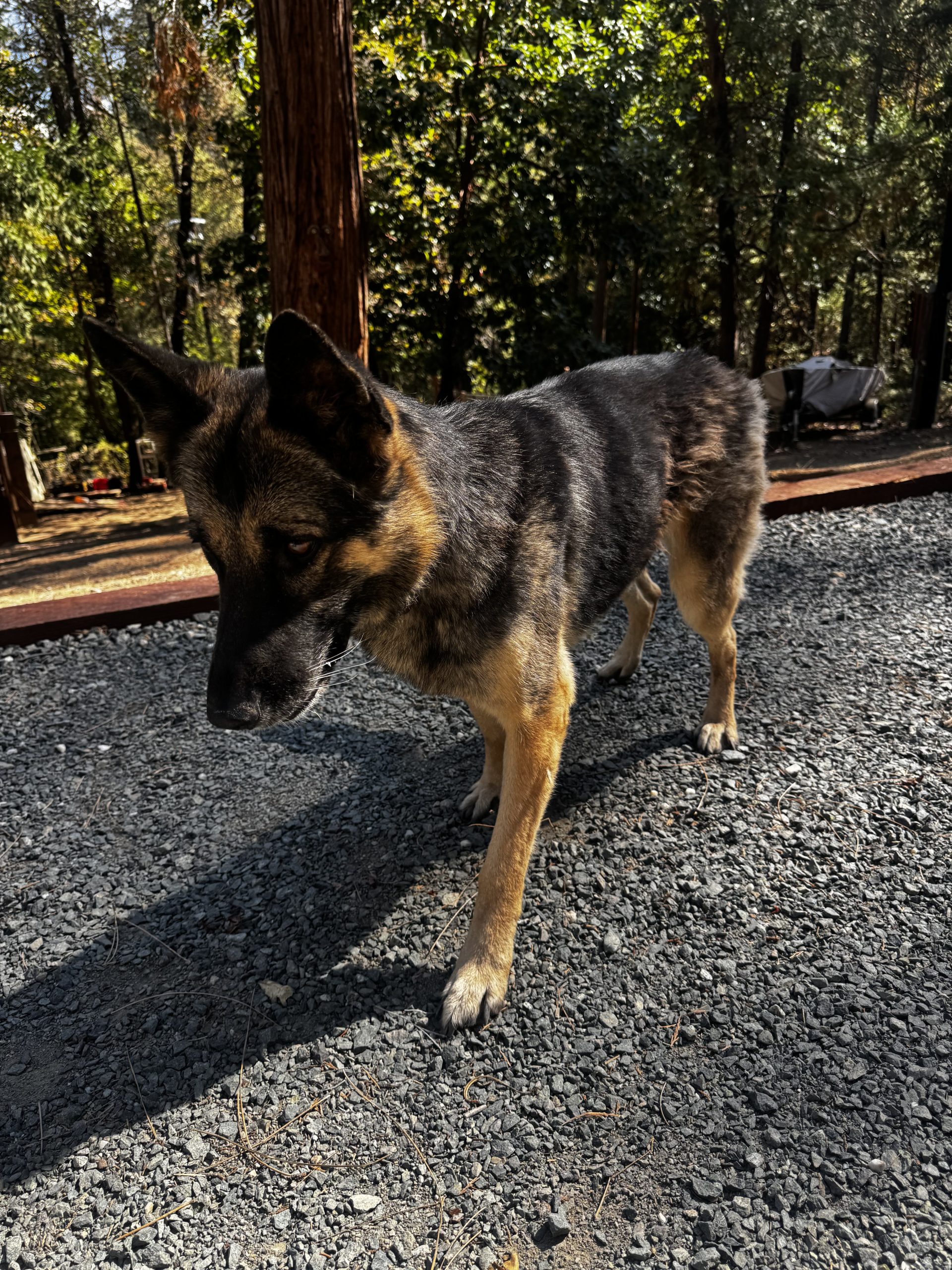
October 5, 2026 at 2:00 PM This female German Shepherd showed up at Camp Gold Hollow on Lake Vera Purdon Road early this morning and doesn’t want to leave. She has a brown leather collar but no tags. Contact 530 277-0082 or 530 913-0954 if she’s your pup.
October 5, 2026 at 10:55 AM Firefighters are kept busy with numerous lightning-caused fires in the high country. Most of the fires are single trees, with little to no extension to the surrounding vegetation. All fires are mapped at less than an acre.
October 5, 2026 at 9:30 AM Air Attack 17 is over a small lightning fire near Meadow Lake and reports another lightning fire, single tree and some grass on fire near the Horse Camp off Hwy 49 near Sattley.
October 5, 2026 at 9:05 AM TNF Patrol has found a possible lightning strike fire near Fordyce Lake. Flames are seen, additional units are being dispatched.

October 5, 2026 at 8:39 AM Air Attack 17 is on a recon flight after last night’s thunderstorms and to locate a possible start in the Canyon Creek area in Sierra County.
October 5, 2026 at 8:01 AM Non-injury accident on Pleasant Valley Road near Mooney Flat, the roadway is clear.
October 5, 2026 at 7:29 AM Reader Laurie caught the rainbow over Lake Wildwood this morning.

October 5, 2026 at 7:14 AM Nevada County Connects update: Be advised that Route 1B (8:30 AM – 4:30 PM) will not run on Monday, October 5th. We apologize for any inconvenience this may cause. Route 1A (7:00 AM-8:00 PM) will still run.
October 5, 2026 at 5:44 AM Here are the overnight NWS Sacramento forecast highlights:
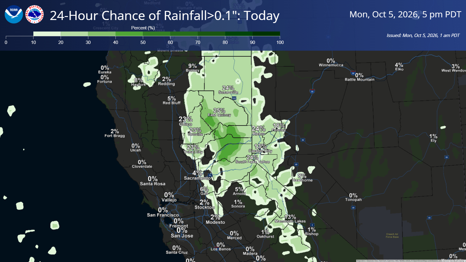
- An area of scattered showers and thunderstorms is moving through the northern Sacramento Valley and northeast foothills early this morning, and is expected to shift out of the area by mid-morning.
- A slight chance for showers and isolated thunderstorms continues for the rest of today in the mountains and foothills north of US Highway 50, with best potential along and east of the crest.
- A Heat Advisory remains in effect from through 10 pm Wednesday for the Delta, Valley, and foothills
- Mostly dry weather with well above normal high temperatures and Moderate/isolated Major HeatRisk continue this week, cooling for the weekend
- Widespread high temperatures in the 90s to lower triple digits Today-Thursday
- Continued chances to reach daily high and high minimum temperatures records at several sites
- Confidence continues to increase in a pattern shift late in the week
- Cooler temperatures and breezy onshore winds likely by the weekend
- Some potential for showery/unsettled weather by next weekend, but this remains highly uncertain

October 5, 2026 at 5:21 AM Quite the lightning show, now tapering off. Very little precip with the thunderstorm activity.
October 4, 2026 at 3:39 PM Caller reporting this was an accidental text notification, no accident or people trapped. All units returning to their stations.
October 4, 2026 at 3:17 PM Reported accident on Independence Trail and Hwy 49. Units in the area are attempting to locate, so far nothing found.
October 4, 2026 at 1:09 PM NWS Update: Confidence continues to increase in a pattern shift occurring Friday into the weekend.
- Some potential for showery/unsettled weather by next weekend, but highly uncertain
- Cooler temperatures and breezy onshore winds likely
October 4, 2026 at 10:07 AM T’is the season. Reader Lu sent this photo, taken by Dylan Anderson, of a yellow garden spider.

October 4, 2026 at 6:47 AM Here are the overnight NWS Sacramento forecast highlights:

- A Heat Advisory remains in effect from through 10 pm Wednesday for the Delta, Valley, and foothills
- Mostly dry weather with well above normal high temperatures and Moderate/isolated Major HeatRisk continue into the week ahead
- Widespread high temperatures in the 90s to lower triple digits Today-Thursday
- Continued chances to approach daily high and low temperatures records at several sites
- Slight chance (10-15%) for an isolated shower/thunderstorm along the Sierra and adjacent foothills north of Highway 50 overnight into Monday
- Confidence continues to increase in a pattern shift late in the week
- Cooler temperatures and breezy onshore winds likely
- Some potential for showery/unsettled weather by next weekend, but highly uncertain

October 3, 2026 at 5:39 PM All aircraft are returning to their respective bases, unable to locateany fire.
October 3, 2026 at 5:31 PM Units in the Carlton area attempted to locate the reported wildfire, so far nothing showing. One permitted campfire in the campground, and a dissipating smell of smoke so far.
October 3, 2026 at 5:28 PM Aircraft have lifted to the Carlton incident.
October 3, 2026 at 5:22 PM Full wildland dispatch on order for a possible vegetation fire near Indian Valley Campground and Hwy 49 in Sierra County. This will be the Carlton incident. Nothing visible on the cameras right now.
October 3, 2026 at 3:17 PM Vehicle off the roadway, and abandoned, on Pleasant Valley Road. Nobody in the vicinity.
October 3, 2026 at 11:19 AM Accident on Hwy 49 Frontage Rd at Allison Ranch Rd. Units at scene.
October 3, 2026 at 10:23 AM Took a sneak peek at the Halloween survey. So you like candy corn at Halloween? But mostly chocolate-y classics.
October 3, 2026 at 7:18 AM A brown pitbull is standing in the roadway on Hwy 49 at Gautier Dr. Is your pup safely at home?
October 3, 2026 at 6:18 AM Here are the overnight NWS Sacramento forecast highlights:

- A Heat Advisory remains in effect from 11 am Today through 10 pm Wednesday for the Delta, Valley, and foothills
- Dry weather and well above normal high temperatures persist through the weekend and into next week
- Widespread high temperatures in the mid to upper 90s are expected with now increasing potential for lower triple digits
- Widespread Moderate HeatRisk with isolated Major HeatRisk Today-Thursday
- Temperatures remain on track to approach daily high and low records at several sites over the next few days
- There is increasing confidence in a potential return to more seasonable temperatures late in the week
October 2, 2026 at 7:59 PM Snow IC requests two NSJ engines to continue in, all others can cancel.
October 2, 2026 at 7:56 PM Units are at scene on Snow Tent Road.
October 2, 2026 at 7:47 PM No spread to vegetation and truck has been evacuated on Snow Tent Road.
October 2, 2026 at 7:44 PM Reported truck on fire on Snow Tent Road off Back Bone Road above Malakoff Diggins. Units dispatched.
October 2, 2026 at 7:37 PM A reminder to take that all important survey before Monday!

October 2, 2026 at 6:48 PM Caller reporting this as a false alarm, cooking only. All units canceled.
October 2, 2026 at 6:46 PM Smoke check in the Quaker Hill Cross area. White smoke coming from a backyard. Units dispatched.
October 2, 2026 at 3:19 PM Two large boxes have taken up residence in the southbound lanes of Hwy 49 near the West Broad St ramp. Use caution and watch for the retrieval operation.
October 2, 2026 at 10:19 AM The heat advisory is now in effect from 11:00 am Saturday through Wednesday 10:00 pm for our area. Hydrate!

October 2, 2026 at 9:16 AM Of course their guesstimator was wrong, power is back on in LWW.
October 2, 2026 at 8:20 AM PG&E’s guesstimator has 2:45 pm as the estimated restoration time for the LWW outage.
October 2, 2026 at 7:58 AM Looks like a minimum of 866 PG&E customers in the Lake Wildwood and Rough and Ready area are out of power.

October 2, 2026 at 7:56 AM Reader-reported power outage in Lake Wildwood.
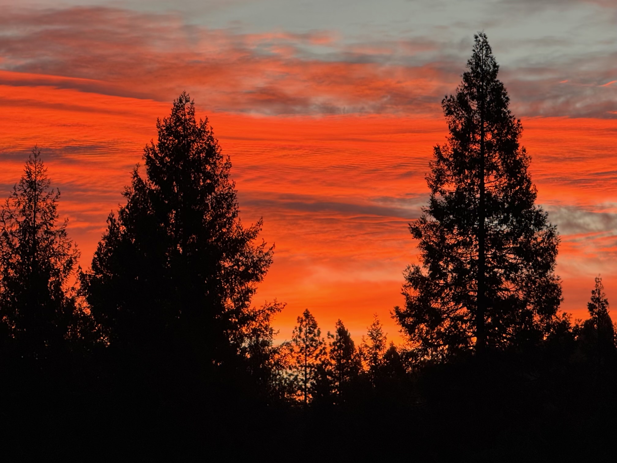
October 2, 2026 at 6:54 AM Rise and shine says reader Adrienne.
October 2, 2026 at 6:09 AM Here are the NWS Sacramento overnight forecast highlights:

- A Heat Advisory remains in effect from 11 am Saturday, October 3 through 10 pm Monday, October 5 for portions of the Delta, Valley, and foothills
- A prolonged period of dry and seasonably warm weather remains on track through the weekend and into much of next week
- Forecast high temperatures in the 90s today rise to the mid to upper 90s from the weekend onward
- Areas of Moderate HeatRisk today become widespread Saturday into next week
- There is some potential for daily high and low temperatures to approach records at some locations
- Light winds persist remaining largely terrain driven
October 1, 2026 at 9:37 PM Nevada County Connects Transit System Alert: Be advised that Route 1B (8:30 AM – 4:30 PM) will not run on Friday, October 2nd. We apologize for any inconvenience this may cause. Route 1A (7:00 AM-8:00 PM) will still run.
October 1, 2026 at 7:43 PM Power has been restored in Peardale, way ahead of the estimated time.
October 1, 2026 at 7:35 PM The estimated time of restoration for the Peardale outage is 10:30 pm. That’s a guess as good as yours or mine.
October 1, 2026 at 7:19 PM In the Hwy 174 corridor from Mosswood Ct to Burma, some 870 PG&E customers, are out of power.

October 1, 2026 at 7:09 PM Reported power outage in Peardale – unknown extent.
October 1, 2026 at 4:19 PM Power outage affecting 50 PG&E customers along Banner Lava Cap Rd near Butterfly Dr. A tree fell on the power lines.
October 1, 2026 at 3:28 PM So, how do YOU Halloween? It’s never too early to take our survey!
October 1, 2026 at 1:41 PM Big rig driver and CHP unit have mostly extinguished the fire with multiple extinguishers. Fire units to continue to check it out.
October 1, 2026 at 1:38 PM Big rig on westbound I-80 near Whitmore Grade with heavy smoke and flames showing. Units dispatched, including aircraft.
October 1, 2026 at 1:33 PM Air Attack 17 remains over the 1/4-acre Feeley incident. Slow to no rate of spread, helicopter 514 is on scene as well. No structures in the area.
October 1, 2026 at 10:04 AM A dog is runing in the roadway on Hwy 49 near Rush Creek Wy and Lowden Ln, watch out for the pup please.
October 1, 2026 at 9:52 AM Heat advisory in effect from 11 AM Saturday to 10 PM Monday. Hydrate!

October 1, 2026 at 9:22 AM Vehicle blocking one lane of Hwy 49 at the Oregon Creel Day Use area. Use caution.
October 1, 2026 at 8:19 AM Vehicle accident on Dog Bar Rd across of Emery Ln, units dispatched.
October 1, 2026 at 5:19 AM Here are the overnight forecast highlights:

- A prolonged period of seasonably warm weather looks to continue through the upcoming weekend and into next week
- Forecast high temperatures in the 90s, pushing toward the upper 90s into the weekend
- Areas of Moderate HeatRisk today and Friday expands northward through the weekend and into next week
- Hottest temperatures are still anticipated over the weekend, although there is potential for well above normal temperatures continuing into next week
- Dry weather persists alongside generally light winds

October 1, 2026 at 5:07 AM Last months log can be found here.