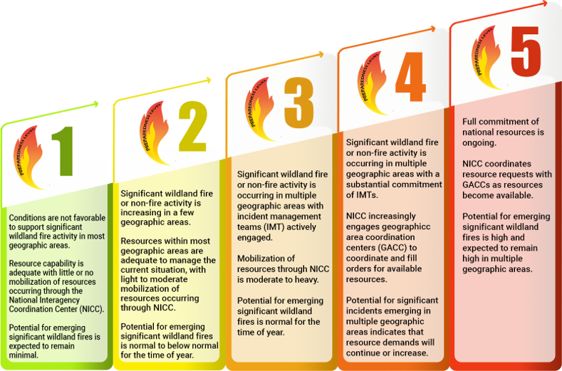
National Preparedness Level: 5 (On a scale from 1 to 5)
Northern California PL: 3
Southern California PL: 3
Smaller, local incidents are listed in the Happening Now section.
Current National Situation:
July 27, 2026 – Initial attack was light with 170 fires reported. 13 new large fires reported and 2 large fires contained.
| Nationwide yesterday | Year to date | 10-yr average |
| Fires: 170 Acres: 106,859 | Fires: 42,379 Acres: 4,185,831 | Fires: 33,344 Acres: 3,350,425 (2016 – 2025 as of today) |
| California | Year to date | 5-yr average |
| Fires: 3,838 Acres: 195,439 | Fires: 5,034 Acres: 239,180 |
Regional fires
| Incident Name | State | Lead Agency | Size (acres) | Percent Contained | Estimate of Containment | Personnel | Structures Destroyed |
| Mooney | CA | NEU | 25 | 100% | July 23, 2026 | 20+ | 1 |
| Chute, Yuba canyon | CA | NEU | 163 | 90% | July 28, 2026 | 929 | 0 |
| Elephant, Loyalton area | CA | TNF | 13,930 | 98% | August 18, 2026 | 180 | 0 |
California fires
| Incident Name | State | Lead Agency | Size (acres) | Percent Contained | Estimate of Containment | Personnel | Structures Destroyed |
| Biscar | CA | NOD | 69,352 | 92% | July 30, 2026 | 555 | 0 |
Out of state fires
Map information using data provided by the National Interagency Fire Center. The data is subject to change.
Weather Outlook
Areas of elevated conditions are expected from northeast California and far southeast Oregon into the northern Great Basin today from southwest winds 15-25 mph with gusts 25-35 mph amid relative humidity of 5-15%. Temperatures will be cooler today and closer to normal in the northern half of the West, and extensive smoke shading will result in temperatures 10-15 degrees cooler than they would otherwise be from central Oregon into central/northern Idaho and Montana. Extensive smoke will also drift east through the Dakotas, Minnesota, and into the Ohio Valley. Isolated mixed wet and dry thunderstorms will develop this afternoon across southwest Montana and Wyoming this afternoon capable of several new ignitions. Hot and dry conditions are expected in much of central and southern California, while isolated wet monsoon thunderstorms are expected in the Southwest into eastern Utah and Colorado, but rainfall footprints will be smaller than those observed last week.