
Fire at a glance (numbers)
- Incident Name:
- State:
- Lead Agency:
- Size (acres):
- Percent Contained:
- Estimate of Containment:
- Personnel:
- Structures Destroyed:
Hirz, Shasta-Trinity NF. Eleven miles east of Lakehead, CA. Timber, chaparral and tall grass. Minimal fire behavior. Road, area and trail closures in effect.
September 12, 2018 at 7:54 AM
Firelines continued to hold the Hirz Fire. Today, crews will focus on holding and mopping up contained areas and securing the remaining uncontrolled edge of the fire near South Fork. Additional crews will continue suppression repair efforts in affected areas.
September 10, 2018 at 9:50 AM
Firelines continued to hold the Hirz Fire. Today, crews will focus on holding and mopping up contained areas and securing the remaining uncontrolled edge of the fire near South Fork. Additional crews will continue suppression repair efforts in affected areas.
Recreation Area Closures: To provide for public safety during the suppression of the Hirz Fire, Shasta-Trinity National Forest lands, roads, and trails around the fire perimeter have been closed (Order No. 14-18-16, bit.ly/2Nbt9sE [case sensitive]). On August 31, the closure was expanded, and some recreation sites are temporarily inaccessible, for example the Pacific Crest Trail between Castle Crags State Park and Ash Camp, the Cabin Creek Trailhead, and the Girard Ridge Lookout. The McCloud River Arm of Shasta Lake remains closed to boat access north of Holiday Harbor and the Shasta Caverns Ferry. Recreation sites closed due to the Hirz Fire are Hirz Bay, Moore Creek, Pine Point, Ellery Creek, Dekkas Rock and McCloud Bridge. For specific recreation information, please call the Shasta Lake Ranger District at (530) 275-1587 or the Mt. Shasta Ranger Station at (530) 926-4511.
September 9, 2018 at 9:15 AM
Fire activity will be minimal due to the stable atmosphere and decrease in temperatures with corresponding increase in relative humidity.
Smoke from the Delta fire over spread the Hirz fire and persisted over the area through the night. Fair to poor humidity recoveries were observed along the ridges with relative humidities in the 30-40 percent range, with 50-60 percent relative humidities in the lower drainages. Low temperatures are in the 50s. North-Northeast Ridgetop winds gusted to 15 mph with downslope and down valley winds noted elsewhere.
Forecasted: Smoke will continue to be widespread over the Delta and Hirz fires in produce reduced visibilities through the entire period. High temperatures will be 78-83 on the ridges and 94-99 in the lower drainages. Relative humidities will lower into the 10-18 percent range in the afternoon. North to Northeast Ridge top winds will shift to the south and southwest around midday and gust to 15 mph. Upslope and upvalley winds are expected over the remainder of the fire.
September 8, 2018 at 8:12 PM
Fire activity was minimal today. Threat continues to high value private timber lands, critical wildlife habitat, McCloud Wild and Scenic River, sensitive botanical species, and cultural heritage sites. Areas of isolated heat continue to be worked by suppression crews. Evacuation orders have been lifted for the McCloud River Club. A Type 1 Incident Management Team (CIIMT 4, Kurth) will inbrief tomorrow at 1500.
September 5, 2018 at 9:18 AM
As of 6:00 this morning, the Hirz Fire is no longer in unified command. California Interagency Incident Management Team 5 Incident Commander Rick Young would like to thank CAL FIRE and the Shasta County Sheriff’s Office for their support in managing the incident.
Control lines are now around the entire perimeter of the fire, and firefighters will focus on holding and securing these lines, as well as continuing to increase containment. Crews worked overnight to hold various portions of the fire, including the northeast corner along Squaw Valley Creek where the fire has backed down slowly into established control lines. Firefighters are also monitoring several islands of burning vegetation inside the fire perimeter that are relativity close to control lines. Crews will work today to mitigate these areas to ensure they do not compromise established lines. A priority for firefighters today continues to be eliminating all heat and hazards close to the perimeter of the fire. Unneeded equipment and hose will start being removed from the fireline as areas of the fire transition to suppression repair. Crews coordinating with Forest Service resource advisors have already been successful in completing suppression repair and rehabilitation along several contingency lines. This process will continue in the contingency areas, as well as, the areas along the eastern and southern portions of the fire that are contained and cold.
The hot and dry weather pattern continues to affect the region, and vegetation remains very susceptible to burning. Dry vegetation surrounding the fire area remains a concern for firefighters, and crews are working hard to ensure that control lines hold without threat of escape.
Recreation Closures and Evacuations:
To provide for public safety during the suppression of the Hirz Fire, Shasta-Trinity National Forest lands, roads, and trails around the fire perimeter have been closed (Order No. 14-18-16, bit.ly/2Nbt9sE [case sensitive]). On August 31 the closure was expanded, and some recreation sites are now temporarily inaccessible, for example the Pacific Crest Trail between Castle Crags State Park and Ash Camp, the Cabin Creek Trailhead, and the Girard Ridge Lookout.
The McCloud River Arm of Shasta Lake remains closed to boat access north of Holiday Harbor and the Shasta Caverns Ferry. Recreation sites closed due to the Hirz Fire are Hirz Bay, Moore Creek, Pine Point, Ellery Creek, Dekkas Rock and McCloud Bridge.
The McCloud River Club continues to be evacuated as a precaution. No other communities are threatened and there are no other evacuations for any other areas.
For specific recreation information, please call the Shasta Lake Ranger District at (530) 275-1587 or the Mt. Shasta Ranger Station at (530) 926-4511.
September 3, 2018 at 9:15 AM
Over the past 24 hours, firefighters successfully held and strengthened control lines around the western and northern portions of the fire. Fire remained within all control lines overnight, and the tactical backfiring operations consumed much of the dead and down vegetation between the main body of the fire and control lines. Crews increased containment along several sections of the perimeter where the fireline is fully secured with no threat of escape. The majority of fire has been burning with low intensity and has been cleaning out the understory as it moves to the control line.
The warm and dry weather pattern is predicted to continue today with variable winds. Humidity recovery has been poor for the past several nights, and the dry vegetation remains susceptible to burning. Despite moderate fire behavior, smoke will continue to be produced as abundant dead and down vegetation is consumed near Squaw Valley Creek on the fire’s northeast side. The main priority for firefighters today will be holding and securing control lines on the west and north sides of the fire. Crews will also be extinguishing and removing burning material and felling burned hazard trees near control lines. These mopup operations ensure that the fireline is safe and secure, reducing the potential that burning material will flare up or roll across control lines. These measures result in increased containment.
Another priority for the incident will be starting to repair areas affected by fire-suppression efforts on the southern half of the fire and along contingency lines. This process focuses on rehabilitation and repair of areas affected by the suppression efforts. Crews will work with Forest Service resource advisors to implement repairs that will minimize such issues as surface erosion and weed spread and will repair damaged roads and trails.
September 1, 2018 at 9:41 AM
Firefighters made great progress overnight on the Hirz Fire. Crews worked heavily on the western and northern edges of the fire to connect and improve the control lines. With favorable weather conditions yesterday afternoon and into the early morning hours, firefighters accomplished a significant amount of their planned burning operations, further securing control lines. Tactical burning operations have been crucial for building containment in the rugged areas where direct fire attack with firefighters is not possible.
Crews have also made significant progress in extending containment around the southwest corner of the fire and continue to further secure the fireline moving north along the western side of the fire. The southern and eastern sides of the fire remained secure overnight with no reported issues. Crews will continue to patrol and extinguish any hot spots that are found along the perimeter.

Fire activity could increase today as the warming and drying trend persists. The shallow inversion is predicted to lift late this morning, which will allow helicopters and fixed-wing aircraft to fly earlier in the day to assist with suppression efforts. Light northeast winds should push the smoke away from communities north of the fire. Firefighters will continue to strengthen and improve all control lines around the fire today. Crews will secure and hold previous firing operations along Yellowjacket Mountain and work eastward into Squaw Creek. With a majority of the south and east sides of the fire now secured, firefighters are focusing on increasing containment around the remainder of the fire by connecting the control lines constructed by handcrews and dozers and securing them with tactical firing operations.
Recreation Closures/Evacuations:
The Shasta-Trinity National Forest has expanded the Hirz Fire Closure with Order No. 14-18-16. This order has closed affected National Forest roads, trails and recreation sites near the Hirz Fire. Residents, landowners and lessees are allowed to enter the fire area to access their land and residences. The McCloud River Arm of Shasta Lake remains closed to boat access north of Holiday Harbor and the Shasta Caverns Ferry. Recreation sites closed due to the Hirz Fire are Hirz Bay, Moore Creek, Pine Point, Ellery Creek, Dekkas Rock and McCloud Bridge.
The McCloud River Club continues to be evacuated as a precaution. No other communities are threatened and there are no other evacuations for any other areas.
For specific recreation information, please call the Shasta Lake Ranger District at (530) 275-1587.
August 29, 2018 at 10:44 AM
A community meeting will be held on Thursday, August 30 at 6:00 P.M. at the Dunsmuir Community Center located at 4835 Dunsmuir Avenue in Dunsmuir, California.
Current Situation:
Last night the fire burned with lower intensity due to cooler temperatures and higher relative humidity. Firefighters were able to strengthen and improve the fireline through a combination of direct and indirect tactics, which included firing operations and the implementation of hose lays in the northwest corner of the fire, south of Tombstone Mountain. Crews continued to prepare for firing operations all along the western edge of the fire. Firefighters patrolled and ensured that areas of heat were mitigated along the southern portion of the fireline. All contained fireline along the eastern and southern portions of the fire remained secure throughout the night.
Temperatures are predicted to be slightly cooler today with the inversion layer projected to lift around midday. Smoke is likely to affect surrounding communities. Helicopters and fixed-wing aircraft will drop water and retardant on the north and west sides of the fire as visibility improves throughout the day. Firefighters will continue to strengthen and improve the fireline with firing operations and hose lays, in a south-southwest direction from Tombstone Mountain, as conditions allow, in order to connect the fire to the indirect firelines created by handcrews and dozers. Crews will further increase and improve containment lines in less active portions of the fire by removing hazard trees, strengthening lines, and extinguishing heat near the perimeter. Indirect and contingency lines continue to be constructed and strengthened along Yellowjacket Ridge and areas to the north, east, and west of the fire.
The incident command post will be relocated to McCloud today to allow crews more efficient access to the active northern and western areas of the fire. A smaller base camp will remain in Shasta Lake City to support firefighters working on the southern portions of the fire.
August 27, 2018 at 10:24 AM
The containment line from Bucks Peak west, towards Middle Salt Creek and east toward Salt Creek continues to hold and crews will monitor it to keep the fire from threatening the communities to the south and west. The fire continues to move north/east. In the area of Tombstone Mountain the fire is being slowed by the rocky terrain. Firing operations continue along the McCloud River drainage and in Green Mountain area. Crews will continue working near Yellowjacket Mountain in the northern extent of the fire to construct containment lines.
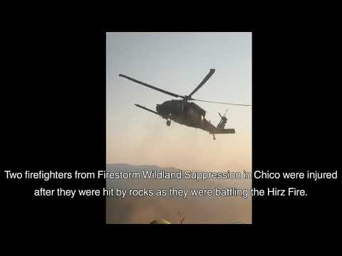
Aircraft have been used for years in firefighting, from water and retardant drops to transporting smoke jumpers. Recently firefighting organizations have started using a new technique borrowed from the military, rappelling from helicopters. In areas too rugged or too remote to hike into in a timely manner having the ability to rappel in can be invaluable. On the Hirz Fire we have been fortunate to have one of two rappel helicopters in California assigned to assist the firefighting effort. On this fire these specially trained teams have been inserted on Tombstone Ridge and other locations out in front of the fire to cut helispots (helicopter landing zones) and to deploy food, water, and other supplies to hotshot crews working in remote, inaccessible locations.
August 26, 2018 at 9:25 AM
The Hirz Fire was active near High Mountain, Oak Creek and the McCloud River to the north. Fire continues to back down the McCloud River to the east, and has progressed towards Tater Hill and Tombstone Mountain. Firing operations are complete from Bucks Peak west towards middle Salt Creek along the southwest corner of the fire. Crews continue to hold the fire on the west side of the McCloud River as the fire advances north. The terrain along the McCloud river drainage becomes more difficult with less access along road systems. Steep slopes and increasing winds will challenge containment efforts within the fire area.
Recreation Closures: The McCloud River Arm is closed to boat access just above Holiday Harbor and the Shasta Caverns Ferry. Recreation sites closed due to the Hirz Fire are: Hirz Bay, Moore Creek, Pine Point, Ellery Creek, Dekkas Rock and McCloud Bridge. Due to the Carr Fire, Beehive Campground is closed.
All evacuations have been lifted for the south half of the fire. However, The McCloud River Club is currently under mandatory evacuation and is located approximately 10 miles southwest of McCloud Reservoir.
The Shasta-Trinity National Forest has closed the area within the Hirz Fire to public access. National Forest System roads and trails and recreation sites remain closed. Residents, landowners and lessees are allowed to enter the fire area only to the extent necessary to access their land and residences.
Recreational Facilities Open for Visitors: Bailey Cove, Fisherman’s Point, Centimudi, and Jones Valley are just some of the facilities open to the public on the shores of Lake Shasta. For specific recreation information, please call the Shasta Lake Ranger District at (530) 275-1587.
August 25, 2018 at 12:02 PM
All evacuations were rescinded for the Hirz Fire as of 10:00 am Friday August 24th. There are no evacuations on the Hirz Fire at this time.
Current Fire Situation: The fire continues to be most active in the north near High Mountain and upper Chiquito Creek. The fire continues to back down to the road along the McCloud River. If conditions allow, crews will continue to use strategic firing operations to hold and secure fire lines in the Bucks Peak and Middle Salt Creek area. Crews continue to strengthen the western line to protect communities. Fire activity may be visible from Interstate 5 so please use caution while driving through the area.
Other than two small fires that burned in the Nawtawaket Mountain area in the 1920s and 30s the Hirz Fire is burning in terrain that has not had a recorded wildfire in over 100 years. The Hirz fire is the second largest fire to occur in this area. Since the year 2000, California has seen 12 of the 15 largest wildfires in the state’s history.Large wildfires have been increasing in size and frequency through the 20th century.
Recreation Closures: The McCloud River Arm is closed to boat access just above Holiday Harbor and the Shasta Caverns Ferry. Recreation sites closed due to the Hirz Fire are: Hirz Bay, Moore Creek, Pine Point, Ellery Creek, Dekkas Rock and McCloud Bridge. Due to the Carr Fire, Beehive Campground is closed.
The Shasta-Trinity National Forest has closed the area within the Hirz Fire to public access. National Forest System roads and trails and recreation sites remain closed. Residents, landowners and lessees are allowed to enter the fire area only to the extent necessary to access their land and residences.
Recreational Facilities Open for Visitors: Bailey Cove, Fisherman’s Point, Centimudi, and Jones Valley are just some of the facilities open to the public on the shores of Lake Shasta. For specific recreation information, please call the Shasta Lake Ranger District at (530) 275-1587.
August 21, 2018 at 9:17 AM
Fire continues to spread north in steep rugged terrain with little road access challenging containment efforts. Crews will continue to implement strategic firing operations and secure previously fired lines.
Evacuations remain along Hirz Mtn Lookout Road, Old Mill Rd., and Bollibokka Fishing Club. Structure assessment continues in Salt Creek, along Gilman Rd. and High Mtn Rd.
The National Recreation Area, high value private timber lands, T&E species, sensitive and endemic botanical species, cultural/heritage sites, and developed recreation sites continue to be threatened along with 100 structures along Lower Salt Creek and Gilman Rd.
August 20, 2018 at 7:02 PM
Overnight, fire crews continued firing operations off of Bucks Peak, working south along the constructed dozer line towards Old Mill Road and west towards Middle Salt Creek to protect residences. This strategic firing is progressing slowly to ensure fire behavior is moderated and controlled. The fire will back away from ignition operations, creating a wide black line along the perimeter of the fire. Another tool that firefighters may use over the next few days is an aerial firing technique called Plastic Sphere Dispenser. This enables the ignition of low-intensity fire in areas that are otherwise inaccessible and will be used to burn out interior portions of the fire area.In the northeast, the fire is moving north towards Nawtawaket Mountain and High Mountain. Firing operations around the Bollibokka Fishing Club, have provided a wide fire break for protection of the club.
The fire is moving north in Nawtawaket Creek and Winniwaket Creek towards Nawtawaket Mountain and High Mountain. Tactical firing operations have moved past the Bollibokka Fishing Club and continue up the McCloud River drainage. Rocky ground with dispersed fuels will slow the fire spread to the north but it will continue to the ridge. Firing operations continue off of Bucks Peak, working south past Old Mill Road and north towards Middle Salt Creek. Fire will back away from ignition operations into Long Tom Creek. Fire that crossed Hanland Peak is backing towards Middle Salt Creek.
August 19, 2018 at 10:38 AM
Firing operations were successful yesterday and throughout the night on the western edge of the fire. Burning operations are a slow process and will take time to complete. Crews continue preparation work and clearing for additional firing operations to improve the strength of the line and to keep the fire at a low intensity. The goal is to create a wide black line along the western edge to stop the fire from spreading any closer to the residents and other improvement in the I-5 corridor. Bulldozer work has also been productive in building and strengthening line on the ridge tops on the western edge of the fire. Fire behavior was minimal to moderate with the strong inversion that covered the fire area. Favorable weather conditions will allow firefighters to continue to improve fire lines on the southwest and northeast portions of the fire. Structure protection remains in place for the Bollibokka Fishing Club and the structures that were evacuated in the southwest area.
Residents of Old Mill Road, Bonnie Vista Lane, Top of the Hill Trail, Hirz Mountain Road, the north side of Gilman Road, and the Bollibokka Fishing Club are still evacuated. Currently, there is not a designated evacuation shelter, but residents who need assistance can contact the American Red Cross at (844) 236-0153. This phone is staffed by volunteers so you may need to call several times before it is answered. County residents can sign up to receive emergency updates and critical information through www.shascom911.com using the Code Red program.
Smoke Forecast: A high pressure system is building the forecast area for the next several days will return to seasonal diurnal pattern with upslope/up canyon winds during the afternoon and downslope/down canyon after midnight. For daily smoke updates: https://tools.airfire.org/outlooks/NorthernCalifornia
Road Closures: Gilman Road continues to have a soft closure in place for the area between Old Mill Road and the McCloud River Bridge. Residents who live south of Gilman Road within the soft closure area, who have not been notified to evacuate, will be allowed to continue accessing their property. Please use extreme caution when driving Gilman Road and be alert for fire suppression vehicles and crews working along the road.
Forest Closures: The Shasta-Trinity National Forest has implemented a forest road and trail closure order for the Hirz Fire area to reduce the risk to the public and firefighting personnel. The Hirz Fire Closure Area boundary roughly begins at the I-5 corridor and Gilman exit up to I-5 and Fender’s Ferry Road, over to High Mountain then down Gilman Road to I-5. See attached map and closure order for full details. Please see the full closure order: https://www.fs.usda.gov/Internet/FSE_DOCUMENTS/fseprd592414.pdf.
Recreation Closures: The McCloud River Arm is closed to access at Hirz Bay. Campgrounds impacted by the Hirz Fire are Hirz Bay, Moore Creek, Pine Point, Ellery Creek, Dekkas Rock and McCloud Bridge. Sites already closed due to the Carr Fire include Lakeshore East Campground, Beehive Campground, Sugarloaf Boat Launch and launching only at Antlers Boat Launch.
Recreational Facilities Open for Visitors: Bailey Cove, Fisherman’s Point, Centimudi, and Jones Valley are just some of the facilities still open to the public on the shores of Lake Shasta. For specific recreational facility status, please call the Shasta Lake Ranger District at (530) 275-1587.
August 18, 2018 at 9:15 AM
Overnight, fire behavior moderated with downslope winds and slightly higher relative humidity. Firefighters continued to work to improve fire lines on the southwest and northeast portions of the fire. Structure protection is place for the Bollibokka Fishing Club, which is near the northern reach of the fire. The priority for today is the south and west fire lines. Firefighters will be bringing fire down along the bulldozer and hand lines from Buck’s Peak to tie back into the main fire along Gilman Road. The goal is to create a wide black line along the western edge to stop the fire from spreading any closer to the residents and other improvement in the I-5 corridor.
Participants from an International Disaster Management Seminar are shadowing the Incident Management Team to experience the incident command system in action, and learn about organizing for response to disasters.
Residents of Old Mill Road, Bonnie Vista Lane, Top of the Hill Trail, Hirz Mountain Road, the north side of Gilman Road, and the Bollibokka Fishing Club are still evacuated. Currently, there is not a designated evacuation shelter, but residents who need assistance can contact the American Red Cross at (844) 236-0153. This phone is staffed by volunteers so you may need to call several times before it is answered. County residents can sign up to receive emergency updates and critical information through www.shascom911.com using the Code Red program.
Gilman Road continues to have a soft closure in place for the area between Old Mill Road and the McCloud River Bridge. Residents who live south of Gilman Road within the soft closure area, who have not been notified to evacuate, will be allowed to continue accessing their property. Please use extreme caution when driving Gilman Road and be alert for fire suppression vehicles and crews working along the road.
Recreation Closures: The McCloud River Arm is closed to access at Hirz Bay. Campgrounds impacted by the Hirz Fire are Hirz Bay, Moore Creek, Pine Point, Ellery Creek, Dekkas Rock and McCloud Bridge. Sites already closed due to the Carr Fire include Lakeshore East Campground, Beehive Campground, Sugarloaf Boat Launch and launching only at Antlers Boat Launch.
Recreational Facilities Open for Visitors: Bailey Cove, Fisherman’s Point, Centimudi, and Jones Valley are just some of the facilities still open to the public on the shores of Lake Shasta. For specific recreational facility status, please call the Shasta Lake Ranger District at (530) 275-1587.
August 17, 2018 at 8:53 AM
Public Meeting: There will be a public meeting Friday, August 17th at 6pm at the Lakehead Lion’s Club located at 20814 Mammoth Drive, Lakehead, California 96051.

On Thursday, firefighters were aided by stable air systems caused by a persistent inversion layer that did not lift until late in the day. The Incident Commanders conducted an aerial survey and observed moderate fire behavior across the fire area. As a result, the Hirz Fire grew slowly to 9763 acres and firefighters increased containment to 7% by securing additional containment along Gilman Road. Expansion on the southwest flank of the fire, closest to the community of Lakehead, was minimal. As a result firefighters have been able to construct additional dozer line on this portion of the fire.
No additional evacuations were ordered today. Evacuations along Old Mill Road, Bonnie Vista Lane, Top of the Hill Trail, Hirz Mountain Road, the north side of Gilman Road, and the Bollibokka Fishing Club are still in effect. Structure assessment and protection continues along Old Mill Road, the Bollibokka Fishing Club and the north side of Gilman Road east of Old Mill Road.
The fire continues to move predominantly northward in the Nawtawaket Creek drainage and over the summit of Hanland Peak toward Middle Salt Creek.
Favorable weather conditions will continue as firefighters work throughout the night. On the western flank, dozers will construct additional fire line. Firefighters will continue to hold the line along the southern and eastern flank and will work towards containment on Gilman Road near the McCloud Bridge.
Road Closures: Due to the threat of fire to structures north of Gilman Road between Old Mill Road on the west side and Hirz Mountain Road on the east side, this area was evacuated on the evening of August 14th. A “Hard Closure” is in effect for Old Mill Road, Bonnie Vista Lane, Top of the Hill Trail, and the Hirz Mountain Road Only firefighters and law enforcement resources are allowed to enter those road systems during the “Hard Closure”. No residents will be allowed back in the area identified until the “Hard Closure” is lifted.
Additionally, Gilman Road will have a soft closure in place for the area between the Old Mill Road intersection and the McCloud River Bridge. Residents who live south of Gilman Road within the soft closure area, who have not been notified to evacuate, will be allowed to continue accessing their property.
Recreation Closures: The McCloud River Arm is closed to access at Hirz Bay. Campgrounds impacted by the Hirz Fire are Hirz Bay, Moore Creek, Pine Point, Ellery Creek, Dekkas Rock and McCloud Bridge. Sites already closed due to the Carr Fire include Lakeshore East Campground, Beehive Campground, Sugarloaf Boat Launch and launching only at Antlers Boat Launch.
Recreational Facilities Open for Visitors: Bailey Cove, Fisherman’s Point, Centimudi, and Jones Valley are just some of the facilities still open to the public on the shores of Lake Shasta. For specific recreational facility status, please call the Shasta Lake Ranger District at (530) 275-2587.
County residents can sign up to receive emergency updates and critical information through www.shascom911.com using the Code Red program.