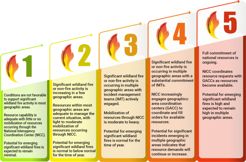
National Preparedness Level: 2 (On a scale from 1 to 5)
Northern California PL: 1
Southern California PL: 1
Smaller, local incidents are listed in the Happening Now section.
Current National Situation:
March 27, 2026 – Initial attack was light with 137 fires reported. 14 new large fires reported and 8 large fires contained.
This report will be posted every Friday unless significant activity occurs.
| Nationwide last week | Year to date | 10-yr average |
| Fires: 137 Acres: 3,365 | Fires: 15,436 Acres: 1,510,973 | Fires: 9,195 Acres: 664,792 (2016 – 2025 as of today) |
| California | Year to date | 5-yr average |
| Fires: 374 Acres: 416 | Fires: 669 Acres: 13,144 |
Regional fires
| Incident Name | State | Lead Agency | Size (acres) | Percent Contained | Estimate of Containment | Personnel | Structures Destroyed |
| Oregon | CA | TNF | 6 | 100% | September 27, 2025 | 40 | 1 |
California fires
| Incident Name | State | Lead Agency | Size (acres) | Percent Contained | Estimate of Containment | Personnel | Structures Destroyed |
| Blue and Log Fires | CA | KNF | 3,713 | 90% | unknown | 88 | 0 |
Out of state fires
Map information using data provided by the National Interagency Fire Center. The data is subject to change.
Weather Outlook
Breezy and dry northerly winds will create elevated conditions across most of the Plains today, while strong easterly winds are expected across central and eastern New Mexico. A cold front will move through the Appalachians, Mid-Atlantic, and Northeast, but precipitation will be light and mostly in the Mid-Atlantic and Northeast. Breezy southwest winds will develop ahead of the front and create elevated conditions across the Piedmont. Hot temperatures will continue west of the Divide in the Southwest, as well. After the cold front moves through tonight, very dry air will spread across much of the South, Appalachians, and East Coast with minimum relative humidity of 8-25% Saturday. Breezy north to northeast winds will also develop across much of the Lower Mississippi Valley and Southeast creating elevated to critical conditions. The very dry air will persist into Sunday, but winds will be lighter. To the west across the Plains, breezy and dry southerly return flow is expected to create areas of elevated conditions over the weekend.
Temperatures will warm across the West once again this weekend, but not to the extreme levels seen earlier this month. In addition, limited moisture will move into the Southwest Sunday, with isolated to scattered mixed wet and dry thunderstorms expected which may result in many new ignitions.
Below normal temperatures and dry conditions will continue across Alaska, while breezy trade winds today across Hawai’i become locally strong over the weekend.