Fire at a glance (numbers)
- Incident Name: Mosquito, Oxbow Reservoir
- State: CA
- Lead Agency: TNF
- Size (acres): 76,788
- Percent Contained: 100%
- Estimate of Containment: October 22, 2022
- Personnel: 761
- Structures Destroyed: 78
Mosquito, Tahoe NF, USFS. IMT 2 ( CA Team 10). Oxbow Reservoir, east of Foresthill, CA. Timber and chaparral. Minimal fire behavior with creeping and smoldering. Area, road and trail closures in effect.
October 23, 2022 at 8:41 AM
The Mosquito Fire is 100% contained as of 5:00 p.m. on September 22, 2022. Isolated smokes may still be visible within the fire perimeter, but do not pose a threat to containment. Crews will continue to patrol and extinguish these smokes as they are observed. In addition, suppression repair work, including hazard tree removal, road grading, and erosion control will continue for the next several weeks.
Fire activity is expected to remain minimal, with any remaining observed heat well within the interior of containment lines.
October 15, 2022 at 9:30 AM
October 11, 2022 at 8:38 AM
October 7, 2022 at 7:08 AM
Minimal fire behavior observed. Suppression repair continues on portions of the fire. Continued threat to power, watersheds, commercial timberlands, historic, cultural, natural resources, and communication infrastructure. Road, area and trail closures in effect. Type 2 CAIIMT 12 (Aragon) in command.

October 6, 2022 at 8:27 AM
Team 12 is in command of the incident. 1,268 firefighters assigned.

October 5, 2022 at 11:28 AM
A Forest Service Burned Area Emergency Response (BAER) team is assessing federal lands burned in the Mosquito Fire, with the goal of keeping visitors and employees safe while recreating and working in the Tahoe and Eldorado National Forests (NF). BAER team assessments focus on emergency actions that are necessary to protect human life and safety, property, critical cultural resources, and critical natural resources such as soil productivity, hydrologic function, and water quality. Emergency actions are intended to minimize any further damage during rainstorm events. Read the full story and check out the photos here.
October 4, 2022 at 6:11 PM
This latest evening update, which is the last update from CAIMT Team 2, updated the containment to 95%.
Fire maps are one of the most popular and well-used items produced on the fire. From gathering the initial data, to adding information to the computer programs, to printing and distributing; creating maps on any fire is a complicated and time-consuming process. Maps are used by nearly every person on the fire. Fire maps are also utilized by members of the public when they want to know more information about how the fire is impacting their communities. In the following video, Terry Williamson, situation unit leader, talks about all the hard work that goes in to producing all the different types of maps used on wildfires.

October 4, 2022 at 7:45 AM
Demobilization of excess personnel continues. Tomorrow CA Team 12, a Type 2 Interagency Team, will assume command of the fire.
October 3, 2022 at 6:55 AM
No change in acreage or containment. Planned actions today include construct direct and indirect line as conditions and opportunities allow. Hold, patrol, improve, and mop-up existing containment lines. Perform hazard tree abatement, and suppression repair.

October 2, 2022 at 8:22 AM
Based on current and expected fire activity, this will be the final daily update for the Mosquito Fire.
Firefighters on the Mosquito Fire worked yesterday to extinguish areas of smoke which were visible in the north and northwestern most area of the fire. Resources were still actively engaged in strengthening control line around a 300-acre area of unburned fuel to the north and have begun to search for and extinguish hot spots around this island. This island is well within a control line. Aircraft used infrared technology to find areas of heat remaining near the North Fork of the Middle Fork of the American River and the Rubicon River, and fire personnel are extinguishing these areas as safety allows.

Incident managers indicate that crews are on track to meet all suppression goals. Containment is currently 90-percent. Suppression repair efforts are underway in areas of the fire that are no longer posing a potential risk of escape. Hazard tree abatement will take extensive time, but safety and future reduction of risk (to humans and wildfires) is top priority for fire managers. More crews and specialized equipment are arriving daily as personnel time-out and are released to their home units or to support other incidents.

October 2, 2022 at 7:53 AM
Mostly clear skies are expected as high pressure building in from the Pacific dominants. Humidity recovery tonight will remain in the moderate range, but will be about 8% lower than Thursday night. Wind gusts from the east to northeast up to 14 mph are anticipated on the ridgetops late tonight. Otherwise, highs on Saturday through early next week will again be about 3 to 4 degrees above normal, ranging in the upper 70s to mid 80s. Humidity is expected to bottom out in the 21 to 28% range each afternoon with moderate recoveries each night. Southwest to west ridge winds gusting up to 12 mph are anticipated from midday into the afternoon for the next several days.
Forest Service BAER team specialists recently completed their field data gathering on federal lands burned by the Mosquito Fire. The post-fire maps and data display soil burn severity (SBS) categories of unburned/very low, low, moderate, and high.
For the Mosquito Fire, the BAER team analyzed approximately 77,207 acres and its burned watersheds for the different levels of SBS. Approximately 66% of the total acres are either unburned/very low or low SBS, while 25% are moderate SBS and 9% are high SBS.
The BAER team’s Mosquito post-fire assessment shows the land ownership acreage for land ownership to be:
- 28,655 acres of Tahoe National Forest (NF) land,
- 23,678 acres of Eldorado National Forest (NF) land,
- 23,102 acres of private lands,
- 1,206 of Bureau of Land Management (BLM) land,
- 518 of Bureau of Reclamation land, and
- 48 of other federal land.
The BAER assessment team used preliminary remote sensing data based on satellite imagery within the fire perimeter with field-validated data collected over several days to produce the final SBS map. The acres analyzed by the BAER team sometimes are different than the burned acres reported on InciWeb. This is due to different methods of collecting and using remote sensing data.

October 1, 2022 at 7:44 PM
No change in acreage or containment this evening. 1,540 firefighters remain assigned to the incident.
October 1, 2022 at 10:21 AM
On Friday, favorable weather provided crews on the Mosquito Fire an opportunity to make extensive progress on the north end of the fire where activity had picked up within an unburned island of vegetation west of Deadwood Road. No forward progression of the fire is expected. Firefighters will focus on reinforcing containment lines over the next several days, and determine how to safely access several small portions of the eastern flank where it has been difficult due to steep terrain. Backhaul operations continue around the perimeter of the fire. Crews are removing hose lays, pumps, and other excessive equipment that is no longer needed to support suppression efforts. Unmanned aircraft systems are being utilized to patrol for hot spots, and aviation resources will be used if necessary in those areas inaccessible to ground crews.
Special mitigation crews have begun the laborious work of removing hazard trees along roadways, especially along Foresthill and Mosquito Ridge Roads. This work is critical to not only reducing future wildfire risk, but also to ensuring the safety of residents, visitors, Forest employees, cooperators and critical infrastructure (utility/transmission lines).
Due to heavy equipment performing suppression repair activities, the public may see heavy dust clouds, which may mimic the appearance of smoke. These dust clouds will have a brown or tan appearance, unlike smoke from the burned area, which is whiter in color. Dust clouds also dissipate and fall quickly, unlike smoke. If you think you see smoke, contact your local fire department.

October 1, 2022 at 7:19 AM
Minimal fire behavior with smoldering and creeping.

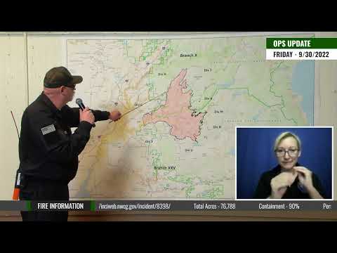
September 30, 2022 at 7:13 PM
Minimal fire behavior observed. Suppression repair continues on portions of the fire. Continued threat to power, watersheds, commercial timberlands, historic, cultural, natural resources, and communication infrastructure. Road, area and trail closures in effect. CAIIMT 12 (Aragon) assigned, planned in-brief 10/4 at 1500. Type 1, CA Team 2 (Johnny) in command.
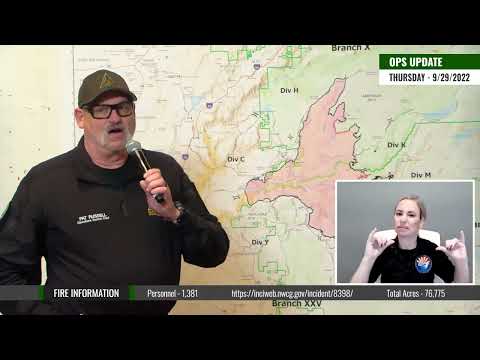
September 30, 2022 at 9:34 AM
Four key operations are the focus of current firefighting efforts on the Mosquito Fire: full fire suppression, suppression repair and strengthening contingency firelines, and hazard tree abatement. Firefighters are still fully suppressing the fire and significant ground crews and aerial resources are still working on the fire.
Firefighters are working to secure fireline in the Blacksmith area and build containment line in areas difficult to access along the Eleven Pines Road on the east side of the fire. Firefighters cannot access the Rubicon River drainage because the very steep terrain is not safe to do so. Contingency fireline, further away, is in place to contain the fire should any unanticipated spread occur. Hotshot crews are also suppressing hot spots of unburned vegetation within the fire’s perimeter. Fire crews work to improve the road conditions around and within the fire’s perimeter. Specialized crews are working extensively on hazard tree mitigation, especially along Mosquito Ridge Road. Hazard tree mitigation operations often mimic commercial logging operations. However, there are no active commercial logging activities currently within the fire area. Piles of logs (decks) which will eventually be removed are being created in areas of heavy tree removal. These dead, diseased or fire-stressed trees pose a safety risk to visitors, forest employees, cooperators and critical infrastructure. A Forest Service Burned Area Emergency Response (BAER) team has been established by the Tahoe National Forest and Eldorado National Forest to begin post-fire burned area assessments of the Mosquito Fire. BAER team assessments and resulting recommendations typically take approximately two weeks to complete.
ROAD CLOSURES
· Mosquito Ridge Road will be closed from 8 a.m. to 6 p.m. daily until further notice. Staffed roadblocks will be located at several intersections.
September 30, 2022 at 6:42 AM
This morning’s PIO map.

September 29, 2022 at 8:48 PM
Resources on the fire continued to work large pockets of unburned fuel (islands) today. Work on the largest of these islands, located in the northernmost area of the fire, is expected to be complete over the next few days.
A Burned Area Emergency Response Team (BAER) began an in briefing today. The Burned Area Emergency Response program assesses damage to both infrastructure and the environment following a wildfire. A BAER team is comprised of 16 people whose purpose is to survey the damage, analyze post-fire conditions, and to take emergency stabilization action to prevent loss of life and property and critical and natural resources. The team includes hydrologists, geologists, soil scientists, road engineers, botanists, biologists and archeologists. Their mission is to study the burn area to predict what may come next.
Skies were mostly sunny to sunny today. After a start in the mid 50s to low 60s, temperatures rose into the mid 70s to low 80s. Humidity again peaked overnight and then fell a few percent toward dawn. However, humidity at sunrise was 15% higher compared to Wednesday. Minimum rh was generally in the 24 to 31% range. Wind were southeast to south at 3 to 7 mph on the ridges and down canyon 3 to 6 mph during the morning, while ridgetop winds became southwest at 3 to 6 mph before noon and then west southwest as the afternoon progressed with gusts up to 14 mph observed. Otherwise winds were upslope or up canyon at 3 to 6 mph during the afternoon with gusts up to 9 mph.
Mostly sunny to sunny weather continues as high pressure remains dominant. Highs will warm to about 3 to 4 degrees above normal on Friday, ranging in the upper 70s to mid 80s. Afternoon humidity is expected to lower to the 21 to 28% range on Friday. Light easterly ridge winds are anticipated on Friday morning, with southwest to west ridge winds gusting up to 11mph during midday to early afternoon. Similar conditions are expected to continue through the weekend and into next week as the upper level ridge builds in.
September 29, 2022 at 10:00 AM
September 29, 2022 at 8:48 AM
While the Mosquito Fire has not grown, more smoke will be produced from interior pockets of unburned vegetation which is slowly burning well within the contained area of the fire’s footprint. Heavier fuels, such as large trees, retain heat for quite some time. What little moisture the fire received last week was not enough to extinguish these fuels. Fire managers do not expect any challenges throughout the next couple of operational periods. To date, over 236 miles of bulldozer line have been constructed, and over 23 miles of control lines have been hand dug by crews. Active fire suppression, suppression repair activities, and hazard tree mitigation all remain priorities. Removing dangerous trees from fire areas will take considerable time, and crews are working diligently on this task, especially along Mosquito Ridge Road.
Due to multiple ongoing hazardous operations requiring the use of heavy equipment from several agencies, Mosquito Ridge Road will be closed from 8 a.m. to 6 p.m. daily until further notice. Please plan accordingly. Staffed roadblocks will be located at Mosquito Ridge Road at the intersection of Foresthill Road; Elliot Ranch Road at the intersection of Foresthill Road; Eleven Pines Road at the intersection of Wentworth Springs Road; French Meadows Road at the intersection of Soda Springs Road
This closure will remain in effect each day until equipment has exited the roadway. Residents and permit holders will only be allowed access before 8 a.m. and after 6 p.m. with proof of residency or with a permit issued by the U.S Forest Service, Tahoe National Forest. Once the closure hours are in effect, anyone remaining in the area will not be able leave until after 6 p.m. No other access will be granted. This closure is necessary to ensure public safety as numerous pieces of large, heavy equipment, and personnel on foot will be operating in this area mitigating hazard trees and repairing utility infrastructure.
September 29, 2022 at 6:39 AM
76,785 acres according to the latest mapping. Minimal fire behavior with smoldering and creeping.

September 28, 2022 at 6:50 PM
Due to multiple on-going hazardous operations, requiring the use of heavy equipment from several agencies, Mosquito Ridge Road will be closed from 8 a.m. to 6 p.m. daily until further notice.
Today on the fire, resources focused on a 300-acre area of unburned fuel at the northern-most tip of the fire. This section is well within containment line but has been burning and producing smoke. Hotshot crews were deployed and worked in the area most of the day. Firefighters also responded to several calls for service in the Volcanoville area, but no threats to containment were found.
Minimal fire behavior with smoldering and creeping observed.
An upper level trough over the Pacific Northwest will move into the Great Basin during the next few days while an upper level ridge will gradually build toward California. This will lead to continued dry weather with temperatures a degree or 2 cooler on Thursday compared to Wednesday, but still near normal. As the system over the northwest moves further east, ridgetop wind gusts will slacken. Afternoon rh should trend higher for Thursday into the 25 to 32 percent range. However, temperatures moderate for Friday and remain a few degrees above normal into early next week as the ridge gradually builds into Northern California.
Skies were clear and sunny. After a start in the low to mid 60s, temperatures rose into the mid 70s to low 80s. Humidity peaked late on Tuesday evening and then fell into the 20 to 30% range in most locations overnight. Humidity changed little the rest of the day, with min rh generally in the 19 to 26% range. Wind were southeast to south at 3 to 7 mph on the ridges and down canyon 3 to 6 mph during the morning, with afternoon ridge winds a bit breezy from the southwest at 5 to 10 mph with gusts to 19 mph and up canyon 4 to 8 mph.
September 28, 2022 at 12:31 PM

September 28, 2022 at 7:51 AM
The Mosquito Fire sustained zero growth and no change in containment percentages over the last operational period. Primary incident objectives of direct and indirect line construction, mop up, suppression repair and hazard tree mitigation are actively being conducted throughout the fire footprint. Suppression repair groups are coordinating across the affected forests and local communities to repair damage, remove the suppression footprint, and restore affected areas to a more natural, pre-fire state.
Minimal fire growth is expected over the next 24 hours. Unburned islands of fuels exist in numerous locations in the fire’s perimeter, but well within fire control features. The potential for small, creeping fires within these unburned areas will persist over the coming days, and both direct suppression and air resources will remain committed to the incident to support any suppression operations as needed.
Near normal temperatures are anticipated over the fire today, with humidity levels ranging between 22-30% and temperatures from the upper 70s to low 80s. An upper-level trough will move through the area bringing increased southwest winds with gusts up to 17 mph. Thursday will bring similar temperatures and humidity levels, with decreasing winds and no significant change to fire spread potential.
Here are the PIO and the Suppression repair maps for today. Clicking/tapping on the maps will download the larger pdf maps.


September 27, 2022 at 6:49 PM
Live stream start s at 7:00 pm.
September 27, 2022 at 6:30 PM
There has been no increase in acreage, minimal fire behavior throughout the day. Virtual community meeting tonight at 7:00 pm.
September 27, 2022 at 12:22 PM
September 27, 2022 at 8:45 AM
Heavier burning fuels may have potential to retain heat and create flare ups. Fire growth will be minimal. Suppression repair efforts are underway in areas of the fire that are no longer posing a potential risk of escape.
Sunny, dry and warm weather continues, with highs in the 80s into early next week. The temperature peaks today then gradually trends down into the upper 70s by Wednesday. Afternoon humidity is expected to be around 21 to 28 percent each day. Light easterly ridge winds mornings, with breezy ridge winds expected Tuesday and Wednesday, out of the southwest, with gusts to 16 to 18 mph. Some increasing clouds, cooler temperatures and higher humidity are expected by the weekend.
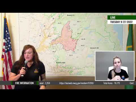
Containment on the Mosquito fire remains at 85% as crews work on fire line construction, mop-up and suppression repair operations. Ground and air resources are utilizing direct engagement when possible along the eastern edge of the fire, including the steep terrain of the Rubicon drainage and along the North Fork of the Middle Fork of the American River. Patrol and mop-up operations in support of the incident’s full suppression strategy continue throughout the affected areas of the fire. A period of relatively hot and dry conditions peaked yesterday, giving way to an upcoming trend of cooler weather with improving humidity levels. Temperatures will peak in the mid- to upper-80s, with humidity levels in the lower 30s. Weather conditions over the next few days support limited fire growth. Significant suppression repair and hazard tree abatement work remain a priority for incident managers as fire containment increases. Multiple suppression repair groups are operating throughout the fire footprint repairing dozer lines, backhauling excess equipment, and other repair operations as needed. Crews are actively conducting hazard tree abatement with the goal of reducing safety risks and forest restoration. A virtual community meeting will be held tonight, Tuesday, September 27 at 7:00 p.m. on the following websites: tinyurl.com/MosquitoFire or on Facebook @TahoeNF or @eldoradoNF.
September 26, 2022 at 6:17 PM
Minimal fire behavior observed today. Continued threat to power, watersheds, commercial timberlands, historic, cultural, natural resources, and communication infrastructure. Road, area and trail closures in effect
September 26, 2022 at 12:00 PM
From today’s PG&E SEC filing: According to the California Department of Forestry and Fire Protection (“Cal Fire”) and the United States Forest Service (“USFS”), on September 6, 2022, a wildfire known as the Mosquito fire ignited near OxBow Reservoir in Placer County, California. According to the incident update posted by the USFS, which assumed command of the 2022 Mosquito fire from Cal Fire, as of September 25, 2022, the fire had consumed 76,781 acres, destroyed 78 structures, damaged 13 structures and was 60% contained. The incident update did not indicate that injuries or fatalities had occurred in connection with the fire. The USFS has indicated to Pacific Gas and Electric Company (the “Utility”), a subsidiary of PG&E Corporation, an initial assessment that the fire started in the area of the Utility’s power line on National Forest System lands and that the USFS is performing a criminal investigation into the 2022 Mosquito fire. On September 24, 2022, the USFS removed and took possession of one of the Utility’s transmission poles and attached equipment. The Utility’s investigation is ongoing.
September 26, 2022 at 11:27 AM
Today’s video ops update.

September 26, 2022 at 8:33 AM
Yesterday, hot and dry conditions persisted across the Mosquito Fire and as a result, mop up efforts remained a priority with hot spots occasionally popping up within the fire footprint. Resources were prepared and directly engaged in the suppression of the hotspots and creeping fire.
Similar warm and sunny conditions are expected today, and a northerly disturbance will bring cooler temperatures later this week. The cooler temperatures are expected to bring winds; however, containment lines are expected to hold well.
Smoke production will peak during the heat of the day today. No major fire movement is forecasted. Hazard tree mitigation and suppression repair remain priority operations. Due to challenging terrain in the Middle Fork of the American River, and to the south along the Rubicon River, ground resources are unable to access and go direct. Therefore, resources are utilizing aviation assets to hold the fire in its current footprint using retardant and water.
The protection of cultural and natural resources during a fire is a high priority along with returning the affected areas to their pre-fire conditions. Management teams will engage the expertise of natural and cultural Resources Advisors (READs) to assist in preventing fire suppression damage. READs provide guidance for suppression actions as well as rehabilitation through coordination with local specialists: biologists, archaeologists, engineers, and recreation planners. Even long after the fire is suppressed, READs will remain on and work through the rehabilitation efforts with the local and national land management agencies.
A virtual community meeting will be held tomorrow, Tuesday, September 27 at 7:00 p.m. on the following websites: tinyurl.com/MosquitoFire or on Facebook @TahoeNF or @eldoradoNF.

September 26, 2022 at 7:07 AM
The IR map shows very little heat remaining on the incident, minimal activity overnight.

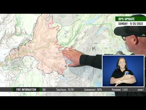
September 25, 2022 at 7:43 PM
76,781 acres brush and timber, 85% contained. Minimal fire behavior with isolated pockets of active surface fire observed today.
A transition to a warmer and Drier conditions will allow fuels to begin drying again. Heavier burning fuels may have potential to retain heat and create flare ups. Fire growth will be minimal. Suppression repair efforts are underway in areas of the fire that are no longer posing a potential risk of escape.
Skies were clear and sunny. After a start in the 60s, temperatures rose into the mid to upper 80s. Humidity recovery occurred round midnight and ranged from 40 to 50 percent, lowering in the early morning with downslope winds. Afternoon humidity dropped to 20 to 28 percent. Winds were northeast 1 to 4 mph on ridges and down canyon 4 to 7 mph in the morning, with afternoon ridge winds southwest 5 to 7 with gusts to 12 mph and up canyon 4 to 8 mph.
Sunny, dry and warm weather continues, with highs in the 80s into early next week. The temperature peaks today and Monday, then gradually trends down by Wednesday. Afternoon humidity drops to around 21 to 28 percent. Easterly ridge winds mornings, with southwest winds gusting to 12 mph afternoons. Breezier ridge winds expected Tuesday and Wednesday, out of the southwest with gusts to 16 to 18 mph. Some increasing clouds, cooler temperatures and higher humidity are expected late in the week.
September 25, 2022 at 8:44 AM
Ops update
September 25, 2022 at 7:56 AM
No change in acreage reported.
Weather: Little change is expected today, with clear skies and warm temperatures. Highs will reach the upper 70s to upper-80s, peaking today and again Monday. Winds start out of the east this morning, shifting to the southwest in the afternoon, with gusts to 13 mph over ridges, strongest at 1400. Afternoon humidity drops into the 20s. Temperatures gradually trend down Tuesday into Thursday as a disturbance pushes high pressure ridging eastward.
Fire behavior: Fire activity (minimal) will continue in areas of the fire that are inaccessible as heavy fuels continue to hold heat. Expect an increase in smoke production as we begin to dry out through the weekend. Expect to see more hot spots show themselves as we continue to dry out.

September 24, 2022 at 6:20 PM
Minimal fire behavior with smoldering observed. No change in containment percentage, but good progress made with extensive mop-up operations. Firefighters worked to gain more containment on the Mosquito Fire, by locating and extinguishing residual hot spots which could cast embers across containment lines (mop up.) Today, firefighters focused on putting containment lines near the North Fork of the Middle Fork of the American River, where terrain has made work difficult. Aircraft was used to build additional containment near Stumpy Meadow and to suppress a small area where smoke was visible.

September 24, 2022 at 8:07 AM
Fire activity Friday proved minimal, with mostly smoldering and creeping interior activity. Isolated pockets of heat produced the most noticeable smoke and accounted for most of the observed activity. After a cool start to the day, humidity decreased and temperatures increased through the afternoon, setting the stage for a more visible fire activity.
Warm seasonal temperatures are expected over the next few days, returning fuels to critically dry conditions. Heavier fuels, which did not experience substantial moisture retention last week, have potential to rekindle and create flareups. Gustier winds are expected to return to the fire footprint earlier next week, and fire weather forecasters have indicated the potential for an uptick in activity. Large fire growth is not anticipated, but firefighters are prepared to apply aggressive and direct firefighting tactics if fire behavior rapidly changes.
Crews experienced in hazard tree removal will focus their attention to felling operations on trees which have the potential to threaten firefighter safety and control lines along the entire fire perimeter. A special hazard tree mitigation crew is expected to be fully operational within the next few operational days. Along the western flank of the fire, containment lines are expected to hold well, thanks to the aggressive and successful work of crews in the early weeks of the fire. Fire personnel from both the ground and the air are continually assessing conditions for opportunities to tie eastern perimeter containment lines together, but in steep, inaccessible terrain, this has proven exceptionally difficult. Air resources will be utilized to provide support to and ahead of crews on the ground.
Firefighter and public safety remain the top priority for incident managers and cooperating agencies. Traffic in and around the communities impacted by emergency response operations is expected to be heavier over the weekend as residents return to their communities and recreational activities intensify. The public is encouraged to remain vigilant for rapidly changing and extensive vehicular and pedestrian traffic. The Mosquito Fire has unfortunately changed the urban interface landscape and has the potential to create visual distractions while driving. Please be mindful of visual distractions and other drivers on and along familiar routes.
September 24, 2022 at 7:43 AM
Minimal fire behavior with smoldering and creeping.
The dry and warming pattern continues with sunny skies. General winds start out of the east this morning, shifting to the southwest in the afternoon, with gusts to 12 mph over ridges, peaking at 1400. Humidity will continue to trend downward. Temperatures today will reach the upper 70s to mid-80s. High temperatures peak on Sunday and Monday, slightly warmer than Saturday. Temperatures then gradually trend down Tuesday and into Thursday as high pressure ridging over the region weakens.
Fire behavior: RH low enough to support fire spread in the fine dead fuels in the afternoon. Little movement expected. Slow rates of spread. Isolated pockets of unburned fuel will have potential to support 2ft flame lengths. Moving into a trend where isolated single tree torching may occur. This fire behavior will be isolated in nature.

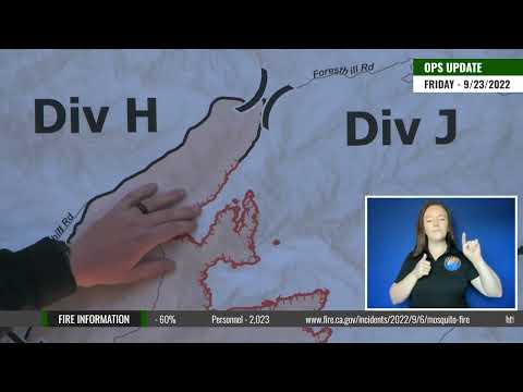
September 23, 2022 at 5:59 PM
76,581 acres brush and timber, 60% contained. Minimal fire behavior with smoldering observed. All evacuation warnings lifted.
September 23, 2022 at 10:05 AM
As of September 23, 2022 at 7:00 a.m., California Interagency Incident Management Team 2 assumed command of the Mosquito Fire and unified command between CAL FIRE, Placer County Sheriff, and El Dorado County Sheriff has been disbanded.
Minimal fire activity and growth occurred on Thursday as well as overnight. This subdued fire activity is in direct relation to the significant wetting rains that cleared out after providing four days of precipitation over the fire area. These steady rain showers, cooler temperatures, and higher humidity created a speed bump effect on the Mosquito Fire, slowing the fire down to just a creeping and smoldering pace. However, the warming trend that started Thursday has started the process of drying out the fuels again and creates the possibility for fire activity to increase in the coming days. The weather will continue to be sunny, warm, and dry with temperatures slowly increasing throughout the weekend. This forecasted weather will also decrease relative humidity which will continue to allow fuels to get back to their critically dry fuel moisture, especially the bigger vegetation, such as heavy dead and down trees, which did not receive enough moisture throughout the storm to cease continued burning.
Firefighters on the ground continue the critical mission of containing the remainder of the fire’s perimeter. Crews will continue connecting all the sections of control line along the eastern flank. Working in the steep and rugged terrain, specifically around the multiple river drainages, remains a challenging task for crews. Aircraft, primarily helicopters, have been assisting in these efforts through water and retardant dropping operations. These coordinated bucket drops of several-hundred gallons of water or retardant help extinguish or slow the spread of hot spots still burning along the fire’s edge. Unmanned Aerial Systems (UAS) are used to map the fire as well as reconnaissance to find hidden hot spots that crews cannot see from the ground. These aerial assets are essential in the coordinated efforts of suppressing this fire.
Fire suppression repair work continues in areas where active fire suppression efforts are complete. Multiple crews are assigned to this large and important operation and are working directly with forest resource advisors. These efforts are to repair or minimize damage to the soil, water, and other resources attributed to fire suppression. This includes items such as removing dozer berms, installing water bars for erosion, repairing roads, and repairing damaged items like fences.
September 23, 2022 at 6:28 AM
Minimal fire behavior with smoldering observed. Evacuation Warning remains in effect for the Stumpy Meadows area. Type 1, CA Team 2 (Johnny) assigned, transition of command on this morning at 0700. The fire will also exit unified command with Cal Fire this morning at 0700.

September 22, 2022 at 7:32 PM
Mostly sunny skies with warmer and drier weather returned today over the Mosquito Fire. Temperatures rose to the upper 60s to mid-70s with light winds from the southwest. This warming trend will continue into the weekend and next week bringing humidity levels down and the possibility of increased fire behavior.
Today, Firefighters continued aggressively building direct and indirect control lines along the eastern flank of the fire. Crews worked to the extend dozer and handlines from Deadwood road down towards the rim of the North Fork of the Middle Fork of the American River. This river drainage remains a challenge for firefighters to access and build control lines down the steep and jagged terrain. Moving from the south edge of the North Fork of the Middle Fork of the American River, crews continued constructing and strengthening control lines towards the Interbay Road.
Firefighters continue to have great success holding the fire along the Interbay Road with strategic firing operations to strengthen this road as a stopping point along the eastern flank. From the Interbay Road system, Hot Shot crews have been building control lines down to the Middle Fork of the American River where more challenges exist with steep and rocky drainages. Firefighters and equipment have constructed nearly continuous control lines from the rim of the Middle Fork of the American River down to the rim of the Rubicon River. Crews are also making great progress on strengthening control lines from the south side of the Rubicon River to Wentworth Springs Road near Stumpy Meadows.
Firefighters have continued to be a presence in the communities and along the southern and western flanks of the fire. These crews are patrolling the containment lines for any signs of heat or safety concerns to the public. Helicopters have played a large part in helping ground crews around the fire today by conducting water and retardant dropping missions. Having aircraft available to knock out hot spots near the fire’s edge has assisted firefighters in strengthening control lines and increasing containment.
California Interagency Incident Management Team 5 will be transitioning command of the incident to California Interagency Incident Management Team 2 as of September 23, 2022 at 7:00 a.m.
September 22, 2022 at 6:56 PM
The evening briefing will start at 7:00 pm.

September 22, 2022 at 6:23 PM
A potential threat remains for Stumpy Meadows.
Fire-suppression work along uncontained hand and dozer lines on the east side was a priority Thursday. California Interagency Incident Management Team (CIIMT) 5 Operations Chief Dave Soldavini reports that “crews had really good success extending containment today.”
The terrain is challenging and in some cases restricting direct access to the fire’s edge, but several hotshot crews working on the east side made incredible progress and will continue to secure firelines in the coming days. Firefighters are still working along contained firelines, extinguishing lingering areas of heat they observe or are made aware of from infrared-flight data.
Also, crews and heavy-equipment operators are working in close coordination with resource advisors to repair areas impacted during the fire-suppression phase. CIIMT 5 has reached the end of its two-week tour and transitioned with CIIMT 2 Thursday; command of the fire will transfer to CIIMT 2 Friday at 7:00 AM.
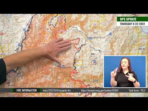
September 22, 2022 at 9:40 AM
Incident Meteorologist Eric Kurth and Fire Behavior Specialist Jonathan Pangburn provide a fire and weather update for Thursday, September 22nd on the Mosquito Fire.

Operations update for Thursday, September 22nd on the Mosquito Fire.
September 22, 2022 at 7:30 AM
On Wednesday, developing showers and thunderstorms moved over the Mosquito Fire from southwest to the northeast. Moderate rain and lightning strikes were observed over the fire throughout the day, with temperatures in the mid-50s to low 60s. Rain showers ended around 9:00 p.m. last night with dry weather and local fog setting in throughout the night hours. Over the past four days, the wetting storm system produced rain totals from 1 to 3 inches over all areas of the fire.
Today, clear skies with warmer and drier conditions will allow fuels to start drying again with the increased potential for fire activity. This warmer and drier period with light west winds will continue to build through the weekend and early next week. Due to the continued work of firefighters and cooperators, all evacuation orders for both Placer and El Dorado counties have now been lifted, allowing residents to return home.
Firefighters continue to patrol the fire perimeter along the southern and western flanks along Quintette, Volcanoville, Todd Valley, and Foresthill communities. These crews are ensuring that no smoldering hot spots remain close to the fire’s edge and that no new issues emerge as we enter into drier weather. Suppression repair work has also started in these areas where fire suppression efforts have ended. Containing the eastern flank of the fire remains a top priority for firefighters. Crews have been aggressively constructing direct and indirect control lines in all parts of the eastern flank, despite the wet and inclement weather. The warmer weather will help roads start drying out, allowing firefighters to access portions of the fireline with the equipment they previously could not reach due to the wet and muddy road conditions. With improved weather comes the ability to utilize aircraft more readily. Helicopters will assist ground crews with reconnaissance to search out hot spots as well as water and retardant dropping missions throughout the day.
September 22, 2022 at 6:40 AM
Thursday brings warm, sunny, dry weather that will extend through the weekend. The combination of widespread precipitation and dogged determination of the firefighters led Fire Behavior Analyst Jonathan Pangburn to report that “lingering heat within the fire perimeter will have an opportunity to start moving this weekend, but I don’t anticipate any fire spread as the mop-up operations are going very well.” One of Thursday’s missions includes assisting repopulated communities and ensuring that every hotspot remotely near the fireline is extinguished as well. Another is increasing containment on the east side. A third is fire-suppression repair.

September 21, 2022 at 7:04 PM
With a significant amount of wetting rain throughout the past four days, fire activity has been minimal and the Mosquito Fire has remained in its current footprint. Firefighters have used this opportunity to make great progress all around the fire before the next warming trend arrives tomorrow.
Firefighters continue to patrol the southern and western sides of the fire to ensure there are no hot spots, threats of escape, or dangerous conditions that could threaten the communities. On the north end of the fire, crews have been working to secure and hold control lines along Deadwood Road as well as to strengthen the firelines heading south into the North Fork of the Middle Fork of the American River. Working in steep, rugged and slippery conditions, crews have pushed down into the river drainages of the North Fork of the Middle Fork and the Middle Fork of the American River in order to tie in control lines and secure the eastern flank of the fire. With many of these sections now completed, firefighters will work to strengthen them to ensure they hold if fire activity increases. Crews have also completed most of the portions of the control line from Eleven Pines Road and McCulloh down to the edge of the Rubicon River drainage where more challenges lie. Crews and equipment are continuing hazard abatement work in the Ramsey Crossing area. These operations include removing fire weakened trees and snags that pose safety issues to both firefighters and the roadways.
Suppression repair work continued throughout the day in areas where there is not active fire suppression efforts. This work includes addressing more than 200 miles of dozer line around the Mosquito Fire in which the berms will be removed and water bars will be implemented to reduce erosion. Forest resource advisors are working directly with these crews to repair the hand and dozer fire lines, roads, trails, staging areas, safety zones and drop points used during fire suppression effort. Dry weather with a warming trend will begin Thursday and continue into next week. Warmer temperatures, lower humidity, and light winds are expected.
September 21, 2022 at 5:46 PM
Minimal fire behavior with continued precipitation over the fire area. CAIIMT 5 (Young) assigned and CAIIMT 2 (Johnny) mobilizing, tentative transition to command on 9/23.
The Foresthill Transfer Station will be open for spoiled food disposal only, tomorrow, Sept. 22, 8 a.m. to 5 p.m. The transfer station will resume normal operations on Friday, Sept. 23. The station is located at 6699 Patent Rd in Foresthill.
September 21, 2022 at 5:05 PM
All evacuation orders have been lifted for the Mosquito Fire in Placer County. The Tahoe National Forest is closed to the public to support fire suppression efforts.
The following road closures are still in effect:
- Foresthill Rd at Elliot Ranch Rd
- Mosquito Ridge Rd at Gorman Ranch Rd
- Soda Springs at the North Fork of the American River
- McKinney Rubicon Springs
September 21, 2022 at 2:00 PM
Repopulation is underway in the last zones in El Dorado County. All evacuation orders have been lifted.
September 21, 2022 at 9:57 AM
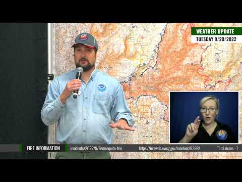
Operations update for Wednesday, September 21st on the Mosquito Fire.

Incident Meteorologist Eric Kurth provides a weather update for Tuesday, September 20th on the Mosquito Fire
September 21, 2022 at 7:50 AM
Continued rain showers along with colder temperatures kept fire activity to a minimum overnight and the Mosquito Fire held in its current footprint. The Flash Flood Watch for the fire area expired at midnight with no significant issues observed. Additional rain and afternoon thunderstorms are forecasted for today with high humidity and cool afternoon temperatures expected. Drier and warmer weather returns Thursday, with a warming trend into the weekend and into next week.
On Tuesday, Firefighters took advantage of the breaks in the storm to construct and secure various sections of control line on the eastern flank of the fire. Accessing the fireline down in the river drainages remains a difficult and challenging operation, especially with approximately 2.50 inches of rain falling over the fire in the past several days. With the minimized fire activity, crews have been able to build direct control line along the fire’s edge without the concerns of the dangerous and explosive fire behavior experienced in the initials days of this fire. Firefighters will continue to increase containment on the eastern flank throughout the coming days.
Depending on weather conditions, rotor-wing aircraft remains available to assist ground crews with waterdropping operations. Crews are working to clear and mitigate hazard trees in the southeast corner of fire along the Eleven Pines Road and near McCulloh. These fire weakened trees pose a hazard to firefighters as well as being a threat to spreading fire across containment lines should they fall and cast embers into unburned vegetation. Firefighters continue to make good progress in hooking the southeast corner from Stumpy Meadows to the Rubicon River.
Suppression repair efforts will continue today with multiple crews working around the fire. The goal of suppression repair is to return damaged areas to a stable condition that reflects pre-fire conditions. Firefighters will work alongside forest resource advisors throughout the suppression repair process.
September 21, 2022 at 7:45 AM
Operations Chief Steve Burns with California Interagency Incident Management Team 5 summed it up at the morning crew briefing: “Lots of things are still happening on this fire. We’re not done yet. We’re getting close, but there’s still a lot of work to be done.” For example, fire-suppression repair work is in full swing where the fire perimeter is considered contained. And on east side, which is largely uncontained, crews are getting very close to finishing fireline construction. Expect containment to gradually but steadily increase in the coming days.
September 21, 2022 at 7:16 AM
Northeast ridgetop winds and downcanyon winds were light, and a weak inversion developed overnight. Low temperatures Tuesday night dropped into the 40s, and relative humidity values rose to 100%.
Today, showers and thunderstorms will linger, but dry, warm weather returns Thursday, with the trend continuing through the weekend. Total rainfall amounts from the multi-day storm system are expected to range from 1.5 to 2.5 inches.
The next virtual community meeting will live streamed Thursday, September 22 at 7:00 PM.
September 21, 2022 at 6:51 AM
Containment is now at 49%. Minimal fire behavior with continued precipitation over the fire area.
September 21, 2022 at 6:04 AM
Minimal fire behavior overnight.

September 20, 2022 at 7:57 PM
The current storm system continued to produce rain showers throughout the day over the Mosquito Fire. Rains were lighter this morning with a slight break midday which caused some atmospheric instability. Thus far, the total accumulation for this storm has ranged from 1 to 2.25 inches of rain over the fire. Isolated thunderstorms moved from south to north across the fire area this afternoon. A Flash Flood Watch remains in effect for the fire area until midnight for potential ash and debris flows due to the presence of these thunderstorms.
With the continued moisture, cooler temperatures and higher humidity, there was no new growth of the fire perimeter throughout the day. Firefighters were able to increase overall containment through the completion of several sections of fireline along the eastern flank. Crews and equipment remained out on the fireline throughout the day working in the rain to continue the mission of constructing and securing control lines around the remainder of the fire. Firefighters remained cautious during periods of heavy rain by seeking shelter, then reengaging in their efforts when the rain slowed and opportunities presented themselves. Great progress continues to be made all along the eastern flank during this period of subdued fire activity. Firefighters understand the importance of securing this flank before warmer and drier conditions begin later this week with the potential to increase fire behavior among the still critically dry fuels. Aircraft was able to be utilized today for several reconnaissance missions in efforts to map and locate hot spots difficult to spot by ground crews. As active fire suppression efforts wind down in some portions of the fire area, suppression repair efforts have started. The goal of suppression repair is to return damaged areas to a stable condition that reflects pre-fire conditions. These repair efforts include actions such as erosion control, repairing fences, debris removal, and removing berms created by dozers. Firefighters will work alongside forest resource advisors throughout the suppression repair process.
With the increase in containment and current fire conditions, several more evacuation orders were lifted by the Placer County Sheriff’s Office this afternoon.
September 20, 2022 at 4:03 PM
Placer County evacuation update.
Zones lifted to an Evacuation Warning:
Zone 6A – Corner of Elliott Ranch Rd and Foresthill Rd
Zone 21A – East of Humbug Ridge, west of Westville, south of the North Fork of the American River, north of Foresthill Rd
Zone 25A – East of Humbug Ridge, Sawtooth Ridge down to the North Fork of the American River
Zones now open with no restrictions:
Zone 2- Baker Ranch MHP
Zone 5- Black Oak Ridge Rd, Blackhawk Ln, Ebbert Ranch Rd, Old Ebberts Ranch Rd
Zone 6B- Finning Mill Rd to Sugar Pine Rd to Elliot Ranch Rd to Foresthill Rd, Big Reservoir Rd, Giant Gap Rd, Hollow Log Rd, Prospect Rd, NF-10
Zone 21B- East of Sugar Pine Reservoir, west of Humbug Ridge, south of the North Fork of the American River, north of Elliott Ranch Rd
Zone 25B- West of Humbug Ridge, Sawtooth Ridge down to the North Fork of the American River
Between 20 and 30 residents and approximately ten homes remain under an evacuation order in Placer County
September 20, 2022 at 2:59 PM
September 20, 2022 at 10:44 AM
Mail being held at the Auburn Post Office due to the fire will be delivered via the Georgetown Post Office starting today. The Georgetown Post Office will provide normal mail delivery services but will not provide counter services at this time.
September 20, 2022 at 8:34 AM
Adding containment to the fire’s eastern flank has become the priority, which is no easy task in rugged terrain, especially with the rainy weather. The multiple river canyons remain challenging for firefighters to safely access and build control lines. Access to portions of the fireline has become compromised with the significant amount of rain received. Due to muddy conditions, many dirt roads that crews use to access the fire’s edge cannot be used. Firefighters will continue looking for opportunities around the fire, especially on the eastern front, to continue constructing and securing direct control lines ahead of a warming and drying weather trend forecasted to start this Thursday.
September 20, 2022 at 7:21 AM
Flash Flood Watch: The National Weather Service Forecast Office in Sacramento has issued a Flash Flood Watch for the Mosquito Fire burn scar through midnight Tuesday, September 20. Ash and debris flows caused by heavy rain are possible. Sign up with Placer Alert or El Dorado CODE RED to receive public safety announcements, including evacuation notifications.
September 20, 2022 at 6:45 AM
Fire behavior Monday was minimal, consisting primarily of smoldering. Rain amounts exceeding 1 inch soaked all areas of the fire, greatly diminishing fire behavior. Lingering areas of heat remain in pockets of smoldering heavy fuels and stump holes.
Showers and thunderstorms will continue Tuesday, potentially resulting in ash and debris flows. Lingering showers continue into Wednesday. Up to 2 inches of total rain is expected from the storm. Drier, warmer weather returns Thursday, warming to near normal into the weekend.
September 20, 2022 at 5:21 AM
Today’s briefing map. Minimal fire behavior with significant precipitation occurring over the fire area overnight.

September 19, 2022 at 6:45 PM
The evening briefing will begin at 7:00 pm.

September 19, 2022 at 6:43 PM
3,113 people remain evacuated in both counties.
September 19, 2022 at 6:07 PM
Minimal fire behavior with significant precipitation occurring over the fire area. Evacuation Orders and Warnings remain in effect. Repopulation occurring where safe. Continued threat to power, watersheds, commercial timberlands, historic, cultural, natural resources, and communication infrastructure. Road, area and trail closures in effect.
September 19, 2022 at 4:33 PM
85 miles of hose was issued to the Mosquito Fire. Once the hose is no longer needed for fire suppression it comes back to supply.
September 19, 2022 at 4:05 PM
Placer County evacuation update. As a result of today’s repopulation effort, 2,128 residents will be able to return to 983 homes. As residents return home, we ask they remain aware of their surroundings as public safety personnel continue to work in the area. Areas still under an evacuation order will continue to be patrolled and monitored by deputies and other law enforcement. We will continue to keep the community updated with new information and thank everyone for their patience and understanding as we monitor the current conditions to determine when it is safest for residents to return home.
Zones Lifted to an Evacuation Warning:
- Zone 1B – Michigan Bluff: Michigan Bluff Rd, Gorman Ranch Rd, Chicken Hawk Rd, Ridge View Rd; north of Chicken Hawk Rd to Foresthill Rd
- Zone 2 – Baker Ranch MHP
- Zone 3B – Crystal View Rd, Bath Rd
- Zone 4B – Downtown Foresthill: Foresthill Rd from Idlewild Rd to Bath Rd, Baltimore Mine Rd, Powerline Rd, Timberland Rd, Sluice Box Ln, Mosquito Ridge Rd west of Soap St
- Zone 5 – Black Oak Ridge Rd, Blackhawk Ln, Ebbert Ranch Rd, Old Ebberts Ranch Rd
- Zone 6 – Finning Mill Rd to Sugar Pine Rd to Elliot Ranch Rd to Foresthill Rd, Big Reservoir Rd, Giant Gap Rd, Hollow Log Rd, Prospect Rd, NF-10
- Zone 7A – Patent Rd
Zones Now Open – No Restrictions:
- Zone 7B – Todd Valley: East of McKeon-Ponderosa, west of Jarvis Rd, south of Foresthill Rd, north of the canyon rim of the Middle Fork of the American River
- Zone 8 – Sierra Vista MHP
- Zone 9 – East of Spring Garden Rd/Foresthill Rd intersection, west of Idlewild Rd, south of Spring Garden Rd, north of Foresthill Rd to Yankee Jims Rd
- Zone 10 – East of the North Fork of the American River, west of Spring Garden Rd, south of Yankee Jims Rd, north of Ponderosa Way
- Zone 11A – East of the North Fork of the American River, west of Sugar Pine Reservoir, south of Big Dipper Rd, north of Yankee Jims Rd
The following zones are still under an Evacuation Order:
- Zone 1A – South of Chicken Hawk & Gorman Ranch intersection, south of Chicken Hawk Rd, south of Foresthill Rd from Elliott Ranch Rd to Deadwood Rd
- Zone 3A – Between 3B and the Placer/El Dorado county line
- Zone 4A – Mosquito Ridge Rd east of Soap St
September 19, 2022 at 3:13 PM
El Dorado County evacuation update
Order to Warning- Volcanoville/Quintette
The following areas are placed back into an evacuation warning, allowing citizens to return to their property. This includes the area East of the intersection of Wentworth Springs Road and Wolfridge Road, West of Stumpy Meadows Lake, South of the County Line, and North of Wentworth Springs Road.
Warning Lifted- Canyon Creek
The evacuation warnings for the Mosquito Fire have been lifted for all homes in the Canyon Creek area.
This includes the area north of the intersection of Spanish Dry Diggins Road and Sliger Mine Road and North of the intersection of Spanish Dry Diggins and Reservoir Road.
Warning Lifted- Bottle Hill
The evacuation warnings for the Mosquito Fire have been lifted for all homes in the Canyon Creek area.
This includes the community north of the intersection of Wentworth Springs Road and Breedlove Road and South of Bottle Hill Road.
Warning Lifted- Grey Eagle
The evacuation warnings for the Mosquito Fire have been lifted for all homes in the Grey Eagle Zone.
This includes the area West of Stumpy Meadows Lake, East of the intersection of Wentworth Springs Road and Breedlove, South of Wentworth Springs, and North of Bald Mountain Canyon.
September 19, 2022 at 3:00 PM
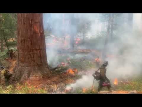
Tahoe National Forest Supervisor Ili Ilano, District Ranger Rachel Hutchinson, and Forest Ecologist Garrett Dickman from the Yosemite National Park share about the history of the grove along with the fire protection measures firefighters are using to protect this vital and significant resource.
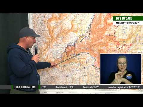
September 19, 2022 at 9:27 AM
Operations Section Chief Donald Fregulia gives us our daily Operational Update for Monday, September 19th, 2022 on the Mosquito Fire.
Containment on the Mosquito Fire has nearly doubled in the past 36 hours. This increase in containment can be attributed to the hard work of firefighters who have been working around the clock to strengthen and secure containment lines in and around the communities. Due to this increase in containment, the current wet weather, and the quick response from our cooperating utility partners, law enforcement officials were able to repopulate many of the surrounding communities on Sunday. Evacuation Orders and Warnings continue to be in place for several communities and areas that are still impacted by the fire perimeter. Firefighters continue to conduct extensive mop-up operations in these remaining areas, including tasks such as extinguishing all remaining hot spots, mitigating fire weakened trees, and working with cooperators to ensure that these areas are safe for the public to return to.
On Sunday, moisture saturation decreased fire behavior significantly; however, areas under thick canopies were less affected by the light precipitation and were still available to burn. Heavier rains and south winds over the fire continued overnight. Firefighters and equipment remained in the communities throughout the night. Protecting life and property remains a top priority for firefighters, and crews continue to patrol the containment lines along the communities to ensure there are no slop overs or spot fires as a result of embers or debris crossing the fireline. Crews and equipment will continue to work along the eastern flank of the fire where it is possible to conduct operations safely in order to keep constructing direct control lines. With rainy and wet conditions in the area, crews must remain vigilant for the increased hazards that come with the additional precipitation. This landscape is already steep and rugged, and it becomes even more treacherous with the addition of rain, making the terrain muddy and slippery.
Continued wetting rains will continue through the day and into Tuesday. A Flash Flood Watch is currently in place for the fire area for potential ash and debris flows from forecasted scattered thunderstorms. The storm is predicted to taper off by Wednesday, with a warming trend starting Thursday.
September 19, 2022 at 9:26 AM
Incident Meteorologist Eric Kurth provides a weather update for Monday September 19th on the Mosquito Fire.

September 19, 2022 at 6:14 AM
76,290 acres and 39% contained. Fire behavior Sunday night was minimal, consisting primarily of backing, creeping, and smoldering. Widespread precipitation has minimized fire behavior.
Monday, rain showers early will evolve into steady rain for the afternoon. High temperatures will be around 60 degrees, and southeast winds could gust up to 15 mph. Rainfall amounts around 0.25 inches are expected, but locally heavy rainfall is possible. Isolated thunderstorms are possible.
Tuesday, scattered thunderstorms are possible and could locally bring potential ash and debris flow. Wetting rain is likely to occur into Wednesday, with storm totals over 1 inch. Drier, warmer weather returns after Thursday

The archive posts of the Mosquito Fire from the start on September 6, 2022 through September 18, 2022 are here.