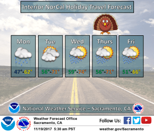
November 20, 2017 – Weather system will bring rain chances to the region today. Mainly dry weather is then expected for the remainder of the week with rain chances limited to the northern mountains.
Discussion
Cloudy skies across interior NorCal as the next weather system moves into the region. Measurable rain has so far been limited to the Coast Range where amounts up to two tenths of an inch have been reported since late Sunday evening. So far, only sprinkles have been occurring over the Sacramento Valley and far northern Sierra Nevada.
Current temperatures are considerably milder compared to 24 hours ago and range from the upper 30s and lower 40s in the mountain valleys to the upper 40s and lower 50s in the Central Valley.
Mostly light precipitation is expected across interior NorCal today as we catch the tail end of a system moving through the PacNW. Satellite imagery shows a wide plume of deep moisture (TPW of around 1.5 inches) moving up from the southwest. Warm-advection and terrain will be the main forcing mechanisms as the cold front remains to the north, and precip in the valley will occur mainly to the north of Sacramento. Heaviest amounts will be in the mountains where up to an inch may occur into this evening. Snow levels will remain above 10K feet.
Dry weather returns Tuesday and Wednesday as high pressure strengthens over the West ahead of the deepening trough over the Gulf of Alaska. Temperatures will be unseasonably mild with upper 60s and lower 70s expected through the Central Valley (around 10 degrees above average).
Another weak system will move through the ridge on Thanksgiving and may bring even lighter QPF (than the current system) to far northern California.
Extended discussion (Friday through Monday)
Weak system will be exiting the area on Friday with a few lingering showers across mountains. Snow levels will remain high, so not expecting any impact there, other than some wet roads. Rest of the extended period characterized by high model uncertainty. ECMWF and GFS out of phase with subsequent waves, leading to low confidence in timing and extent of precipitation for the weekend into early next week.
ECMWF fairly wet for Sunday into Monday while GFS holds off until Monday night-Tuesday. Have left low chance pops across much of the area through the period until better agreement is shown. As it stands now, snow levels look high (above 8-9K feet through the weekend), then perhaps dropping below pass levels by Monday. Will be something to watch depending on which solution verifies.
Temperatures will remain mild through the period, around 4-10 degrees above normal for this time of year.


