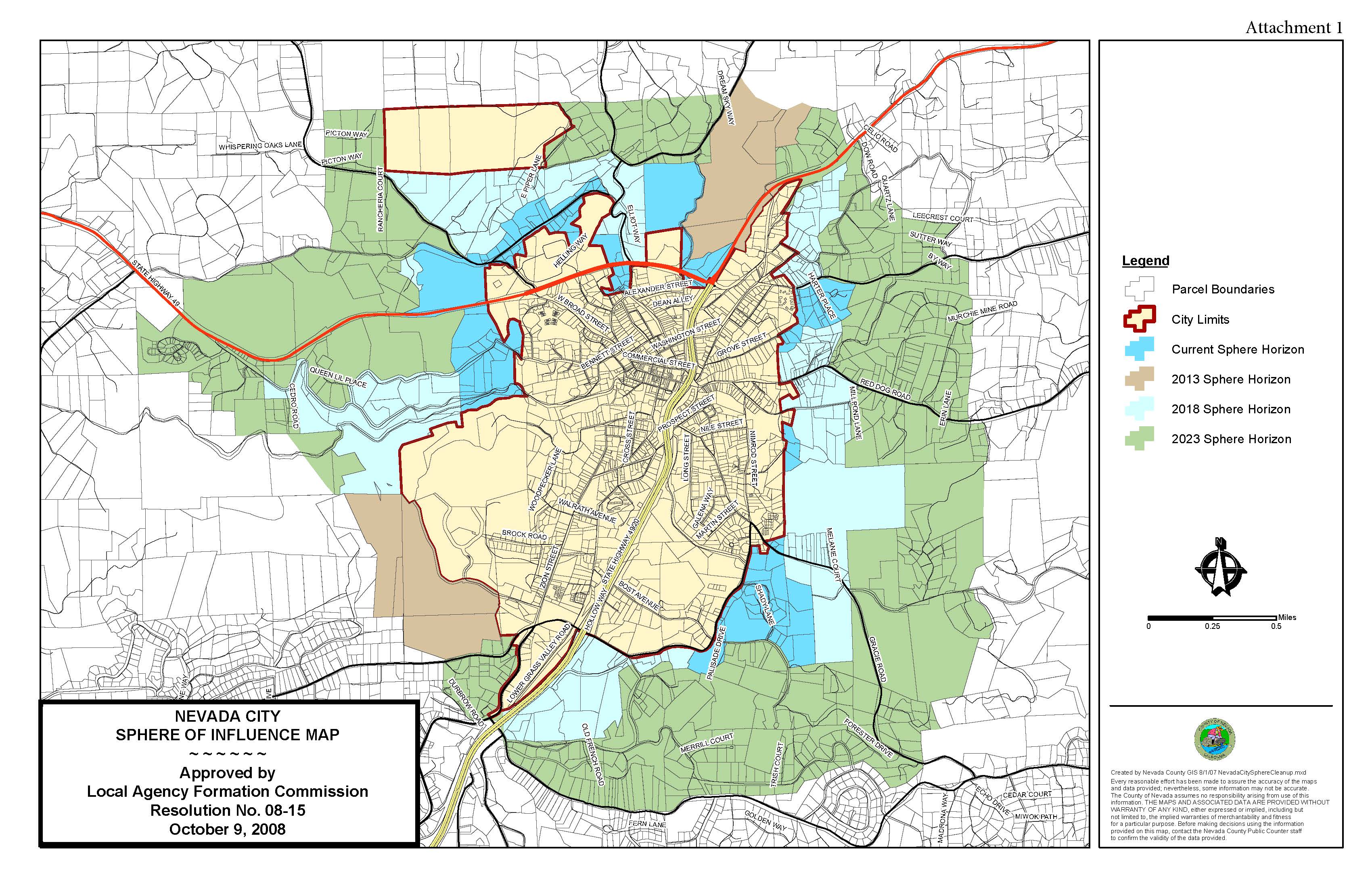
Nevada City, Calif. February 17, 2017 – At their February 23rd meeting the Local Agency Formation Commission (LAFCo) will hold a workshop to consider and provide direction to staff regarding Nevada City’s sphere of influence (SOI) update, including the recommended sphere of influence boundary. The current draft proposal reduces the city’s SOI from 2,907 acres to 1,482 acres and places the remaining acreage in an area of interest designation. No formal action will be taken at the workshop, the Commission will provide direction to staff only.
What is LAFCo?
LAFCo is an independent agency, responsible for coordinating logical and timely changes in local governmental boundaries, conducting special studies that review ways to reorganize, simplify, and streamline governmental structure and preparing a sphere of influence for each city and special district within each county. LAFCo was created by the legislature in 1963, with one LAFCo for each California county. LAFCos are independent agencies of the State of California tasked with administering a section of planning law known as the Cortese-Knox-Hertzberg Local Government Reorganization Act.
In 1972, LAFCos were given the power to determine spheres of influence for all local governmental agencies. A sphere of influence is a planning boundary outside of an agency’s legal boundary (such as the city limit line) that designates the agency’s probable future boundary and service area. Factors considered in a sphere of influence review focus on the current and future land use, the current and future need and capacity for service, and any relevant communities of interest.
In Nevada County,the LAFCo Commission is composed of seven commissioners:
Richard Anderson (County)
Patrick Flora (Cities)
Kurt Grundel (Districts), Vice-Chair
Evans Phelps (Cities)
Josh Susman (Public)
Hank Weston (County), Chair
Nick Wilcox (Districts)
4 alternates:
Dan Miller (County)
Ed Beckenbach (Districts)
Gloria Glenn (Public)
Ben Aguilar (Cities)
The LAFCO staff consists of Executive Officer and Nevada City native SR Jones and Clerk to the Commission Deborah Gilcrest. P. Scott Browne serves as legal counsel.
LAFCo is funded by the municipal and special districts eligible to have commissioners. In Nevada County, 24 special districts, the cities of Grass Valley and Nevada City, the Town of Truckee and the County of Nevada are responsible for the LAFCo’s operational costs. Each agency pays a share which is proportional to it’s general tax revenue. School districts are not a part of LAFCo.
What is a sphere of influence?
A sphere of influence for a city is defined by LAFCo as “a plan for the probable boundary and service area of a local government agency.” LAFCo is now required to review and update each agency’s sphere of influence plan every five years.
The Commission’s sphere of influence policies now state that LAFCo will not include lands in an agency’s sphere that are unlikely to require the services provided by the agency, or lands which cannot feasibly be served by the agency. Commission policy now also provides for the designation of “Areas of Interest,” which are areas beyond an agency’s sphere of influence where land use and other decisions may impact the agency.
In plain English, a sphere of influence is the area immediately outside city limits where development is likely to occur, because of the proximity of existing services such as roads, water, sewer, police and fire. A city will periodically annex parcels in the sphere of influence into the city limits, often new developments or areas with failing infrastructure like sewer systems. Once the annexation is complete, the municipality then receives the property tax of the newly-incorporated parcels. Property taxes from unincorporated parcels are revenue for Nevada County.
Nevada City’s current sphere contains 215 undeveloped parcels and 735 developed parcels – which won’t need city services like water or sewer unless septic systems fail or wells run dry. Roads in the current sphere are mostly county-maintained roads.
Annexations and plans for future annexations
According to the LAFCo staff report, since 1949 Nevada City has completed 49 annexations resulting in the addition of 745 acres to the City boundaries. Since the last sphere update in 2008, the City has completed four annexations:
• Silva Avenue (2008), an annexation of a single 4.5 acre parcel.
• Northside (2009) an annexation of 61 acres in various areas north of town. This annexation brought City-owned Hirschman’s Pond into the City, and cleaned up several areas where the City boundary bisected parcels.
• Gracie Commons (2009), an annexation of less than one acre, associated with a residential project on Gracie Road which has not yet been constructed.
• Grove Street (2013), an annexation of four parcels at the end of Grove Street, initiated in response to a failed septic system on one lot.
Relative to future annexations, City staff has discussed plans to initiate annexation of Sugarloaf Mountain, a City-owned property north of the current boundary, east of Coyote Street. This annexation would likely include several intervening properties, including the Nevada County Consolidated Fire District’s Station # 84 on Coyote Street.
From time to time, City staff has also discussed plans for annexation of other areas, including:
• The former Health Education and Welfare (HEW) facility on Willow Valley Road, which is now privately owned.
• Manzanita Diggings property, which is located west of Coyote Street, nearby the Sugarloaf property.
Proposed changes

Reducing the existing sphere of influence to 1,482 acres would still leave 274 improved parcels with a total acreage of 604 acres and 124 unimproved parcels with a total acreage of 878 acres in the revised sphere.
From the LAFCo staff report: The following list includes brief descriptions of the most significant areas recommended to be retained in the City’s sphere:
• Indian Trails: This 30-lot estate residential project is located on the west side of the City, adjacent to the City-owned Hirschman’s Pond property. Although the development receives treated water from Nevada Irrigation District and uses private septic systems (and thus does not require City services), the area is recommended for continued inclusion in the city sphere as the City holds title to the project’s the trail system.
• Sugarloaf Mountain and Manzanita Diggings: This area includes seven properties located north of the City on both sides of Coyote Street. The City holds ownership to Sugarloaf Mountain (31 acres) and intends to apply for annexation, proposing to designate it for Open Space. The Manzanita Diggins properties, comprised of two properties (totaling 15 acres), is located on the other side of Coyote Street from Sugarloaf. These properties have development potential under the City’s General Plan. The Nevada County Consolidated Fire District owns two parcels (totaling 5 acres) in this area; one parcel is the site of NCCFD’s Station 84 and is connected to the City’s public sewer system. The southern half of a large (110 acre) parcel in this area is also recommended for continued inclusion in consideration of its City General Plan designation for Planned Development.
• Highway 20 (north of Nevada City) Frontage Area: This residential area includes 12 parcels and is located adjacent to the Manzanita Diggins area north of Nevada City, on the northwest side of Highway 20. Although most of the properties are already developed for residential use, the area may provide access points for the Manzanita Diggins area, discussed above.
• HEW (Health, Education and Welfare) Building: Located off Willow Valley Road east of the City boundary, this property was the site of a County-owned facility that has since been purchased by a local developer. The site is connected to the City’s wastewater system, as are several other properties in the immediate vicinity. The area is recommended for continued inclusion in the sphere in consideration of its development potential and the extension of City sewer service.
• Hurst Property: This 90-acre area is adjacent to City boundaries off Gracie Road; the City’s General Plan designates this area for Planned Development.
• Prospector Nursery/Caltrans: This area is located south of Gold Flat Road, and includes a commercial nursery, the Caltrans facility and lands designated by the City for Planned Development. Note that the Caltrans facility is connected to the City’s wastewater system.
• Gallelli Properties: This area is located west of the current City boundary and Providence Mine Road and includes 162 acres in 5 separate parcels. The southern portion is designated for Planned Development by the City’s General Plan, while the northern portion is designated for Open Space.
• Juvenile Hall Property: Located adjacent to the western City boundary off Highway 49, this County facility has been connected to the City sewer system.
• Highway 49 Planned Development: This area is located west of the existing City boundary, south of highway 49 and north of American Hill Road. Portions are designated for Planned Development by the City’s General Plan.
• ‘Incompatible Parcels:’ During the 2008 sphere update, City and County staff identified five properties (one appears to have been subdivided, so there are now six) for which County and City General Plan designations are not consistent. Each of these properties are included within the recommended sphere.
The portions of the 2023 Sphere Horizon that are recommended for removal from the sphere of influence would be designated as an “Area of Interest” in order to ensure the City is notified of development proposals and other projects that may have potential for impacting the City. The proposed “Area of Interest” consists of lands that had previously been included in the 2023 sphere horizon (with the exception of several of the areas listed above, including Indian Trails, Highway 20 frontage, and the Highway 49 Planned Development areas). This area includes 462 developed properties totaling 982 acres, and 94 unimproved properties totaling 366 acres.
Note also that the City indicates that its water treatment plant is located on two parcels off Gracie Road south of the Hurst Ranch properties; adjacent to those two parcels is a property owned by the Nevada County Gun Club, which is connected to City water. Staff suggests the Commission may want to include these three parcels in the sphere.
Nevada City’s concerns
In a report to the Nevada City City Council, City Manager Mark Prestwich noted that “Under the LAFCO Officer’s proposal, there would be no obligation for the County to maintain land use patterns consistent with City interests. This possible conflict has the potential to degrade the City’s view shed, water shed, and overall quality of life afforded to its residents, along with those residents in the present SOI. Further, this proposal ignores the significant contributions by the City in services already provided to the SOI, as outlined below.
Roadways: Several arterial roadways and collectors: Gracie Road, Red Dog Road, Willow Valley Road, Cement Hill Road, North Bloomfield Road, Coyote Road, Old Downieville Highway, Nevada City Highway, and Pittsburg Road serve as the primary access route from residential properties within the present SOI to schools, commercial destinations, and recreational amenities within the City limits. The intense use of these roads by those within the SOI entering the City on a daily basis is a key reason the current SOI boundary is suitable in its present configuration.
Recreation Service: The City presently manages approximately 10 acres of developed park area, 278 acres of Open Space which includes approximately 12 miles of developed trail. The City is also in the preliminary stages of selecting a trail route on the Sugarloaf property which could add up to two miles of developed trail. Using the national standard of 5 acres per 1000 people, the amount of park and recreation amenities managed by the City could accommodate 57,600 people (roughly 58% of the entire County population). The extent to which the City serves the present SOI and beyond is further exemplified by the recreation programs provided by our park system, particularly those programs associated with the pool at Pioneer Park. In 2016, 90% of swim lesson participants and 75% of adult aquatics program participants were from outside of the City. Furthermore, 96% of summer camp participants were from outside of the City.”
The report also mentions Nevada City Fire’s contribution to the mutual aid agreement with Nevada County Consolidated Fire, possible septic tank and well failures. Watershed degradation, especially to Little Deer Creek, “land use patterns could significantly change in a manner that could degrade water quality and severely impact the way in which City residents, and residents beyond, enjoy these amenities for their aesthetic, ecological, and recreational value.”
One of Nevada City’s concerns outlined in the Feb. 8 report reads, “To the extent properties are removed from the City’s sphere of influence, the County could change the zoning to allow uses more intense than provided for in the City’s designation.”
What could change?
Currently, if a project is within Nevada City’s sphere of influence, the City can elect to be the lead agency and process the application, or have the county departments handle the proposed development. This is only a policy, not a statutory requirement aka law.
The topography of the 94 vacant parcels (366 acres) in the proposed sphere of interest, as well as population density, road infrastructure and economic factors make large developments on the outskirts of Nevada City unlikely. Some of the vacant parcels are public lands where no development will take place (National Forest lands.)
Comparing sphere sizes
The table below was provided by Nevada LAFCo. It shows similar size cities and their current sphere of influence acreage.
| Comparable Cities | 2015 Pop. | City Acreage | Sphere Acreage | Last Update | Sphere/City Boundary |
| Jackson, Amador County | 4586 | 2300 | 1219 | 2014 | 53% |
| Angels Camp, Calaveras County | 3811 | 2277 | 3480 | 2011 | 153% |
| Carmel, Monterey County | 3747 | 640 | 850 | 2013 | 133% |
| Rio Dell, Humboldt County | 3372 | 1013 | 160 | 2008 | 16% |
| Nevada City, Nevada County – current | 3194 | 1224 | 2907 | 2008 | 238% |
| Nevada City, Nevada County (Recommended) | 3194 | 1224 | 1482 | 2016 | 121% |
| Yountville, Napa County | 3017 | 966 | 13.5 | 2013 | 1% |
| Alturas, Modoc County | 2723 | 1550 | 2228 | 2010 | 144% |
| Ross, Marin County | 2493 | 985 | 0 | 2007 | 0% |
| Sutter Creek, Amador County | 2457 | 202 | 4 | 2014 | 2% |
Public participation invited
Nevada City invites public participation:
One of the reasons Nevada City enjoys such a special reputation is because of the community’s sense of place. Nevada City’s “essence” as a small, compact, historic town surrounded by green, wooded hills is embodied in the City’s General Plan. Numerous concerns have been raised with the LAFCo staff-developed proposal. Please clickhere to learn more about the issue.
The City Council invites you to participate in the discussion by sending your thoughts on the matter to City Manager Mark Prestwich via email (mark.prestwich@nevadacityca.gov) or to the address below:
City of Nevada City
Attn. Mark Prestwich
317 Broad Street
Nevada City, CA 95959 [source: Nevada City website]
The City Council will have their regularly scheduled meeting the day preceding the LAFCo meeting and will discuss the city’s rebuttal. Nevada City’s meeting begins at 6:30 pm on February 22, 2017. The LAFCo meeting takes place at the Rood Center and begins at 9:00 am on February 23, 2017. The Nevada City item will be heard after 9:30 am.