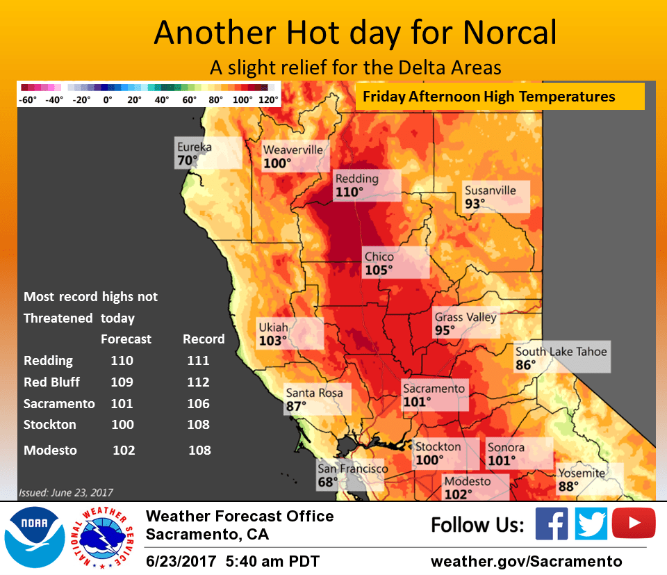
June 23, 2017 – Heat wave continues elsewhere with widespread highs over 100 degrees and warm nights today through Saturday. Isolated afternoon thunderstorms possible over the mountains. Not as hot next week. Heat advisory remains in effect until 11 pm Saturday. Foothill temperatures well into the 90s to 105 degrees through Saturday. Thermal belt areas in the foothills only cooling into the mid 70s to lower 80s for nighttime lows.
Discussion
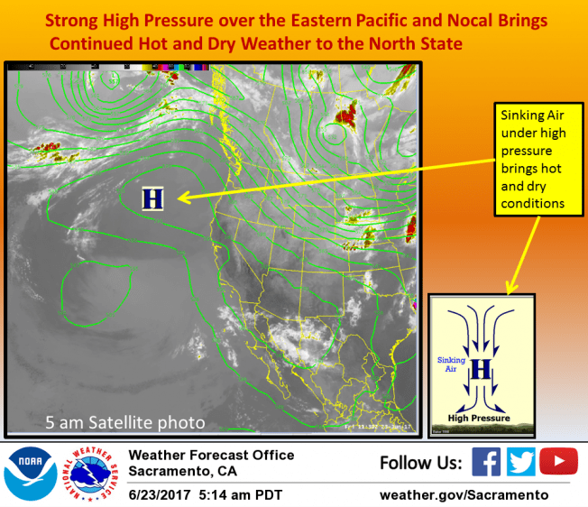
Another hot day today under building upper level ridge. Some relief is in site however for the delta influenced areas thanks to an increased delta breeze. Temperatures this morning running 7 degrees cooler at Travis AFB and 2 to 5 degrees cooler in the Sacramento and Stockton areas. Main question for this area will be how persistent delta push is through the day. NAM/GFS guidance does keep a moderate breeze going through the afternoon and Fort Ord profiler showing marine layer up to about 1200 feet. Satellite fog product and surface observations showing some coastal stratus trickling into the Bay Area as well. Have lowered daytime Max temperatures a bit in delta influenced areas and downgraded Excessive heat warning in this area to a heat advisory.
Elsewhere, conditions expected to come in just a hot as Thursday so kept up warnings/advisories in place unchanged. A few isolated thunderstorms popped up over the Sierra crest on Thursday and expect there may be a few here today south of Tahoe. Little change is expected in the overall forecast for Saturday so expect only minor changes in temperatures. Exception should be the delta and delta influences areas which should see a little more cooling under a somewhat stronger delta breeze.
More significant changes in store for Sunday with upper ridge axis forecast to shift into the Great Basin. Increased delta breeze and cooler airmass should bring general cooling all areas. Southerly flow aloft will continue instability and thunderstorm threat over the Sierra crest Sunday afternoon. Models hinting at a shortwave disturbance pivoting up the back side of the ridge and across the northwest corner of the state for a threat of afternoon thunderstorms over the coast range crest. Cooling continues on Monday as weak upper troughing moves over the coast. Daytime highs Monday should be down to just a few degrees above normal. Stable southwest flow aloft will bring dry conditions so should not see any afternoon thunderstorm activity over the mountains.
Extended discussion (Tuesday through Friday)
Further cooling expected on Tuesday as weak trough moves across the area. Models depicting a few showers across the northern mountains but confidence is low and given limited moisture return, have continued dry forecast. Upper flow becomes more zonal on Wednesday into Thursday with high temperatures within a few degrees of normal. Cooler overnight temperatures will continue the relief from this week’s heatwave. Delta Breeze should be going with further cooling across influenced areas.