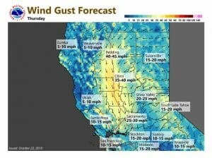
October 22, 2019 – Breezy conditions at times, especially Wednesday into Thursday when elevated fire weather concerns are expected. Dry conditions with above average temperatures forecast through the remainder of the week.
Discussion
Broad ridge over the eastern Pacific and NorCal continues to provide clear skies. Current temperatures range from the upper 20s in the mountain valleys to the mid 60s across milder portions of the Central Valley and foothill thermal belts.
North to northeast pressure gradients are a bit tighter compared to early Monday resulting in gusts in the 15-25 mph range across the northern Sacramento Valley and local gusts of 20-40 mph in the foothills of Butte County.
Warm and dry weather will continue this week with highs forecast to be around 5 to 15 degrees above average. Overnight lows will be mild across windier portions of the valley and in the foothills thermal belts, but will be close to normal elsewhere.
The main concern this week is enhanced fire weather conditions, especially for Wednesday and Thursday, as the short-wave presently moving through southern BC digs into the central US. As this happens, the upstream ridge is forecast to amplify along 130W providing a little better upper level support to the tightening north/northeast surface gradients.
Lighter winds forecast to return later Thursday and continue Friday as the ridge moves overhead.
Extended Discussion (Saturday through Tuesday)
Models in good agreement in dropping an upper trough out of western Canada and into the northern Great Basin on Saturday. Impacts on Saturday will be minimal. There should be a little cooling but daytime highs Saturday are still likely to come in several degrees above normal. Models continue diverged going into early next week with a fairly significant difference in impacts depending on solution. ECMWF continues to dig the upper trough southward into the central Great Basin Sunday while the GFS tracks the trough much farther east into the central U.S. during this same timeframe.
ECMWF solution would bring another round of strong northerly winds to most of the CWA while the GFS solution would leave NorCal under light gradients and lighter north winds. Either way, daytime temperatures cool behind the trough with daytime highs dropping to near normal on Sunday. Leaning towards a middle of the road approach to the winds Sunday and have gone with relatively light north winds. Continued northerly flow will bring a little more cooling on Monday with daytime highs dropping to slightly below normal. Upper ridge slides over the west coast next Tuesday bringing a slight warm up.


