May 5, 2021 – Warm and dry weather will continue today, then cooler Thursday and Friday. Increased north winds and warmer into the weekend and early next week.
Discussion
Upper level ridge in place over NorCal will bring another dry and very warm day. Surface gradient has weakened and light winds can be expected until onshore flow/delta breeze gets going this evening. Short range ensembles and clusters in good agreement with trough approaching the West Coast tonight and Thursday.
This will initiate onshore flow/Delta breeze, which will cool high temperatures back into the 80’s. Southwest wind gusts up to 25 mph will be possible, higher through the Delta, especially Thursday afternoon.
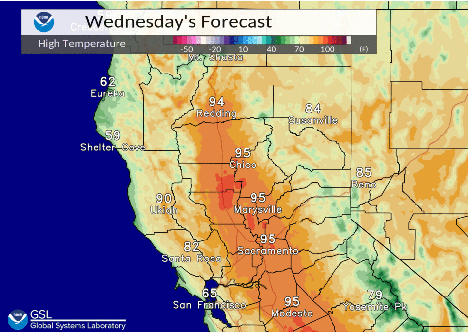
High temperatures will be in the low and mid 90’s today. These readings are 15 to 20 degrees above normal for this time of year. Record highs generally range from 97 to 100 degrees at most locations, so should stay just below record levels.

Ensembles and clusters in good agreement with trough passing through the area Friday and into the Great Basin Region Saturday with upper ridge building back over NorCal.

This will bring a return to much warmer temperatures, increased north winds and elevated fire weather concerns. High temperatures on Saturday will warm back into the upper 80’s to near 90 degrees with north winds gusts 30-35 mph.
Extended discussion (Sunday through Wednesday)
Ensembles and clusters in good agreement with upper ridge gradually shifting east over NorCal into early next week, as trough remains over the Great basin and Rockies regions. This will keep the area in a dry, breezy and warm pattern through the extended forecast period.
Gusty north to east wind and elevated fire concerns likely to persist into Tuesday over much of interior NorCal.