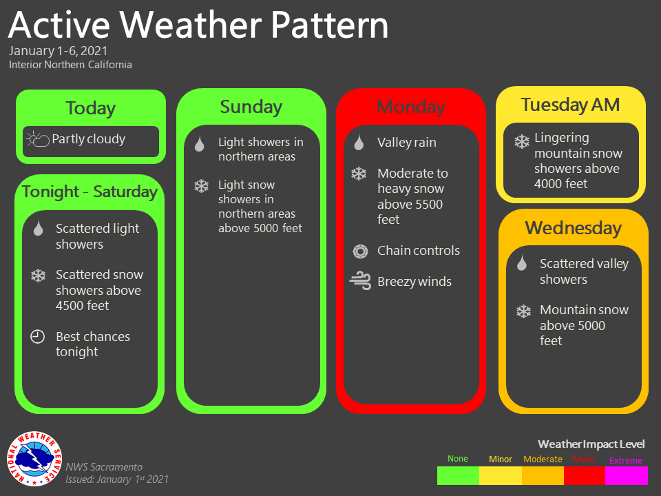
January 1, 2021 – Dry weather continues today with some patchy morning valley fog expected. Another weak system will bring a chance of rain and mountain snow on tonight into Sunday before the pattern becomes more active Sunday night into next week.
Discussion
Satellite imagery indicates a few high clouds are spilling through the ridge along the West Coast, and IR difference imagery is indicating some patches of fog and low clouds over the southern Motherlode, across the mountain valleys of the southern Cascade Range, and a thin sliver of fog is beginning to show up across the northern San Joaquin Valley. Otherwise, skies are mainly clear skies across interior NorCal to begin 2021!
Locally breezy north to northeast winds continue across portions of the foothills and mountains surrounding the northern Sacramento Valley, though surface pressure gradients have been steadily slackening since peaking Thursday afternoon and evening. Still seeing some gusts in the teens and 20s mph across that area, with very localized gusts in the 30s to around 50 mph occurring near the mouth of the Feather River Canyon.
Dry weather will continue today as the upper ridge moves across the area. HREF still indicating likely potential for some fog early this morning in the Central Valley, mainly from the Sacramento region southward. Otherwise, another day of mild temperatures is forecast for New Year’s.
Precipitation chances return for the region tonight. A cold front will quickly weaken later tonight and early Saturday as it drops south bringing very light QPF (less than 1/4 inch to the northern mountains, with a few hundredths of an inch possible elsewhere south to around I-80).
Rain chances will continue over the weekend, especially across the far northern portion of the forecast area (despite the return of weak ridging) as moisture continues to stream into the region from the west. Warm-advection and weak southerly orographic enhancement should be enough to squeeze out an inch or more of QPF across the mountains to the north of Redding. Further to the south, mainly dry conditions (other than a few sprinkles) are expected from Saturday afternoon through most of Sunday along with mild temperatures.
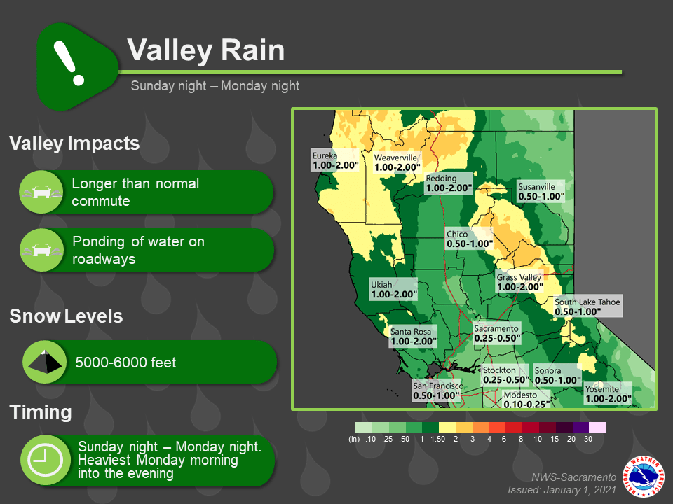
A more impactful system is forecast early next week as the next upstream trough approaches Sunday night, and then moves across the area by later Monday. Steady light to moderate precipitation is expected to develop Sunday evening as warm-advection and forcing increase, but most will occur on Monday as the next cold front moves through. 1 to 3 inches of rain are expected over the mountains with around 1/2 to 1 inch in the Sacramento Valley (lighter amounts to the south).

The heaviest snow is likely to occur Monday and Monday evening across the northern Sierra Nevada where 12-18 inches of snowfall accumulation will be possible over the higher passes. A winter storm watch remains in effect.
Extended Discussion (Tuesday through Friday)
Unsettled weather will be the story for the extended period as a series of troughs pass over the West Coast.
For Tuesday, high pressure looks to briefly fill in behind Monday’s trough, which should bring us a period of drier weather during the day. This will be short lived as models and ensembles continue to favor another storm system moving in by late Tuesday night into Wednesday morning. The latest guidance is not as potent as the previous sets of data, with only an additional 6-12 inches of snow being possible above 4500 feet for the Sierra, southern Cascades, and Coastal Range.
The rain amounts have dropped as well with Sacramento Valley estimated to have around 0.5-1.75 inches of rain and the San Joaquin estimated to be around 0.25-0.75 inches. Timing and strength will likely change over the next few days, so stay tuned to the forecast.
If traveling in the mountains, pay close attention to the forecast and road conditions and adjust plans appropriately.
Looking beyond Wednesday, we may see a brief break in precipitation on Thursday with the next chance for precipitation being Friday. Temperatures during this time frame look to be within +/- 5 degrees their seasonal averages.