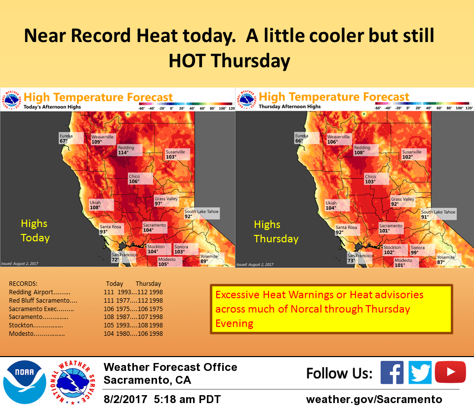
August 2, 2017 – Heatwave continues this week with heat warnings and advisories until Thursday evening. Isolated late-day thunderstorms over higher terrain each day. A little cooler this weekend and next week but still warmer than normal.
Discussion
Upper level high pressure ridge and subsidence over the west coast will bring continued hot temperatures over the next couple of days. Overall airmass changes little today so expect daytime highs to come in similar. Excessive heat warnings and heat advisories will continue through Thursday evening. Weak upper level southeast flow will continue to bring sub-tropical moisture northward into the region which in turn will bring a threat of afternoon and evening thunderstorms to parts of the higher terrain.
Blended Total precipitable water satellite image shows 1 inch plus TPW pushing into the southern CWA. GFS TPW may be a bit overdone but does show this subtropical moisture continuing to edge northward through the short term period. Pinpointing where the afternoon thunderstorm activity will occur will be as difficult as always but stability proggs do indicate a threat of afternoon thunderstorms over both the Sierra Cascade crest and parts of the coast range crest as well today. With such high precipitable moisture values it is likely the most thunderstorms will contain at least light rain with some producing heavier rainfall.
Models in good agreement on Thursday in bringing a weak shortwave over the ridge and into the Pacific Northwest on Thursday. This may cool the airmass just a bit especially over the northern most portions of the state and may also force the afternoon thunderstorm threat a bit farther south. Airmass cools a bit more on Friday as slightly cooler air filters in behind the shortwave but daytime highs Friday are still expected to remain a few to several degrees above normal.
Afternoon mountain thunderstorms continue to be a threat on Friday as weak flow aloft and plenty of moisture remain over the forecast area. Still expecting a bit more cooling on Saturday as a weak upper low moves in off the north coast. Increased southerly flow aloft as a result of this low will bring even more sub-tropical moisture northward for a slightly better threat of afternoon and evening mountain thunderstorms. Have therefore included a thunderstorm threat over all CWA mountain areas Saturday.
Extended discussion (Sunday through Wednesday)
Weak upper low forecast to linger over far northern portions of California through the extended forecast period. This will help to moderate temperatures with highs from the upper 90s to around 106 in the Central Valley and 80s to 90s in the foothills and mountains. Enough moisture and instability will be present to keep a threat of afternoon thunderstorms over the mountains through midweek.