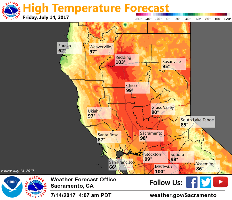
July 14, 2017 – Heating up through the weekend. Slight chance of thunderstorms along the Sierra crest this weekend. Temperatures cool to near average early next week.
Discussion
Clear skies across the region early this morning. Temperatures are pretty similar to 24 hours ago and range from the mid 40s to mid 50s in the mountain valleys to the upper 50s to mid 70s elsewhere.
Temperatures will begin to inch up a bit today as high pressure extends westward and the marine layer is suppressed. Isolated late-day thunderstorms will be possible again in the Sierra to the south of Lake Tahoe.
Widespread triple digit heat will be possible across the Central Valley this weekend as onshore flow slackens and subsidence increases with the stronger ridge. A brief period of northerly wind in the Sacramento Valley on Saturday night and Sunday may result in locally warmer temperatures at the north end of the valley and along the west side – similar to last Friday.
Thunderstorm risk may expand northward along the Sierra crest on Saturday given enough instability and monsoonal moisture. Afternoon activity is expected to move quickly east of the forecast area under southwest flow aloft.
Stronger onshore flow is expected to initiate another cool down beginning Monday as the ridge retreats eastward as a trough nears the West Coast.
Extended discussion (Tuesday through Friday)
Warm, dry weather will continue through next week as weak troughing remains just offshore. This will keep NorCal under the influence of onshore flow, with temperatures within a degree or two or normal into Wednesday and cooler temperatures in the Delta region. Temperatures warm by Thursday, with valley locations approaching the century mark. At this time, monsoonal moisture should remain shunted to the SW portions of the state, so have kept with dry forecast through the period.