January 6, 2017 – Below freezing temperatures in the valley this morning. Rain and mountain snow Saturday with snow levels rising above pass levels Saturday night. Periods of heavy rain Saturday night into Monday and possibly again mid week.
Discussion
Upper ridging over the west coast keeping NorCal under fair skies this morning. Temperatures are running from 8 to 15 degrees below 24 hours ago with the central valley seeing several locations below the freezing mark. Remainder of today looks dry with just a bit of warming under the ridge.
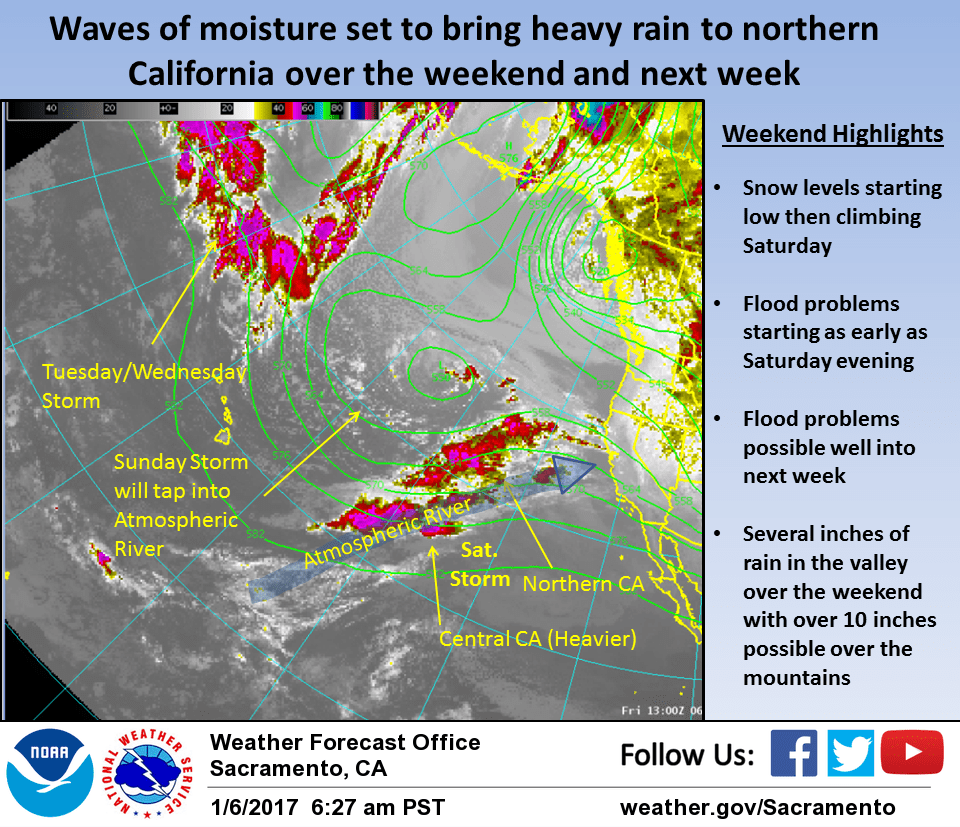
High clouds begin spreading over the area later today ahead of next batch of tropical (atmospheric river) type moisture forecast to move into NorCal this evening.
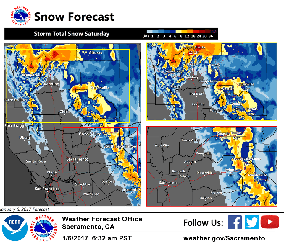
Initial overrunning precipitation starts out light overnight with fairly low snow levels. Main change from previous package was on snow levels tonight over the northern CWA. NAM and GFS both placing snow levels early Saturday down to the Redding level with impactful snow amounts there. This is as a result of cold trapped air at the lower elevations, light northerly surface flow and possible evaporative cooling at the lower levels. We did lower snow levels in this region for tonight but not as low as GFS and NAM imply. For one thing we are not under a particularly arctic airmass at this time and model forecast soundings show a fairly shallow dry layer near the surface.
May see some snow down into the lower foothills tonight but at this time, do not expect snow on the valley floor. Have added a winter weather advisory for snow over the northern foothill and mountain areas tonight and will definitely need to watch for possibility of even lower snow levels.
Snow levels rise slowly during the day Saturday and climb above pass levels pretty much all areas by Saturday evening. as warmer subtropical air is advected into the area.
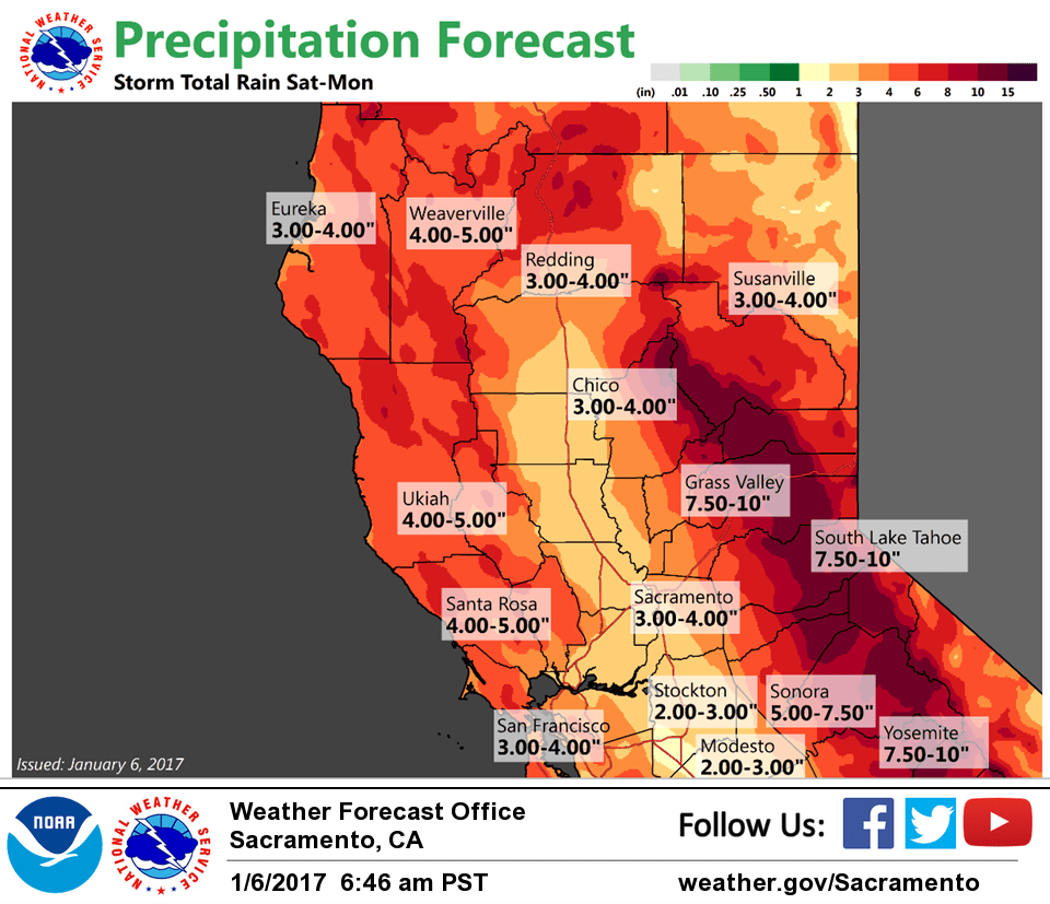
First major batch of moisture hits NorCal late Saturday afternoon and evening bringing periods of heavy rain with snow only at the highest mountain elevations. Made only minor changes in precipitation amounts and flood watch already in place starting Saturday still looks appropriate.
Valley may see an easing in the precipitation rates Saturday night while orographics keeps rain rates going over the mountains.
Another round of moisture quickly slams into NorCal on Sunday keeping the moderate to heavy rainfall going most locations. Moist southwest flow continues over NorCal on Monday. Orographics will keep at least some rainfall going over the mountains while the valley might see a slight break in precipitation.
Cooler polar air starts filtering in on Monday bringing a rapid drop in snow levels. With snow levels dropping, winter snow impacts return to the mountains. At least this combined with lower precip rates should ease new flood concerns temporarily.
Extended discussion (Tuesday through Friday)
Wet pattern is likely to continue through much of next week. The next land-falling atmospheric river is expected to move into Northern California Tuesday into Wednesday. This system will likely bring another dose of heavy precipitation across the region, though probably not quite as heavy as the weekend storm.
Snow levels of 4000-6000 feet are currently forecast, with multiple feet of snow possible above those levels. Lower snow levels will likely mean less runoff, but with rivers and streams likely to be swollen, any additional rainfall will continue the potential for flooding.
A chance of precipitation will be possible through the rest of next week. Longer range models are hinting at another potentially wet storm system late next week.