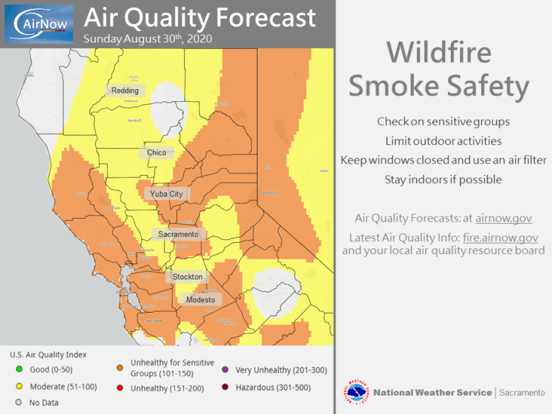
August 30, 2020 – Smoke and haze from wildfires will continue to impact air quality and temperatures for the next several days. Dry weather expected with above normal temperatures. Local north wind early this week.

Discussion
Upper ridging extends inland over interior NorCal with closed upper low west of Point Conception. Moderate Delta Breeze overnight should weaken some today as marine layer depth trends down. About a degree of synoptic warming suggested at 850 mb by models should result in a slight nudge upward on highs, dependent on amount of smoke present. KMFR-KRDD pressure gradient trending up as EPAC surface high builds into Oregon.
N-S surface pressure gradient increases tonight into Monday with some northerly wind of 10 to 15 mph with local gusts to 25 mph developing mainly over Shasta and Tehama counties. Delta Breeze also expected to increase again this evening remaining moderately strong overnight.
Heights/thicknesses trend up Monday into Wednesday as EPAC upper high builds inland over NorCal. Triple digit heat expected in the Northern Sacramento Valley Monday into Wednesday. 90s forecast elsewhere in the Delta, Central Valley, and lower foothills, with mostly 80s for the mountains.
Extended Discussion (Thursday through Sunday)
High pressure from the Desert SW extends over interior NorCal producing dry weather with above normal temperatures. Besides any smoke, skies will be mostly clear. Highs will be roughly 5 to 10 degrees above normal for early September, with this extended hot period likely to continue into early next week.