November 26, 2020 – Breezy north to east winds today, otherwise dry weather expected into early next week with mild days and chilly nights. Cooler with a chance of showers Monday, mainly over the northern mountains, followed by mild days and chilly nights into the middle of next week.

Discussion
A negative 1-2, 5H and 2H anomaly and closed 5H upper low over KLAS today will result in Santa Ana conditions over SoCal, and the late autumn katabatic winds over NorCal. In the wake of the upper low, a positively tilted ridge will build into the Pac NW/Nrn NV region increasing the Nly and Ely pressure gradients over Norcal. About an 8-9 mbs gradient is forecast from KMFR-KSAC and KWMC- KSAC, and this combined with 20s-low 30s kts of NEly-ELY winds at 925 mbs will result in breezy conditions today. Generally, we expect the winds to be below wind advisory criteria for most of the CWA, primarily due to the timing of the strongest band of 925 mbs winds to the early morning hours and before good mixing.
In addition, the mixing height is limited this time of year, generally up to 2 kft or so for most days. However, noting the negative V anomaly (-3.3, the meridional component of the wind) at 1000 mbs mainly over Solano and Yolo Counties at midday, we decided to issue a Wind Advisory for this area highlighted by the SA table. (Outdoor dining could be impacted by winds blowing away napkins and table cloths.) Adiabatic warming effects from the katabatic winds today are expected to shoot max temps into the 60s in the Valley today, several degrees above normal.
Although the winds will decouple in the Valley overnite, strong gusty winds are expected at Jarbo Gap where the gusts can often double the 925 mbs model forecasts (~30 kts tonite), as tight pressure gradients are forecast to continue over the Sierra. Nly breezes are also expected on the W side of the valley before diminishing on Fri. Looks as if the winds may even turn light Sly aloft over the Nrn SJV and Srn Sac Vly where some frost may occur Fri morning.
Pressure gradients relax on Fri as ridging builds into the area, so there will be less wind. With less adiabatic warming effects from the katabatic winds than today, max temps should be slightly cooler. With decreasing winds Fri and into Sat and Sun, we expect frost potential to spread farther N in the Valley and up towards RBL and RDD.
Upper ridging will tend to flatten over the weekend, but a dry air mass will continue over Norcal until Mon. The dry air mass will result in good radiational cooling and chilly overnights (4-8 degrees below normal in the Valley), but mild temps will continue during the afternoons.
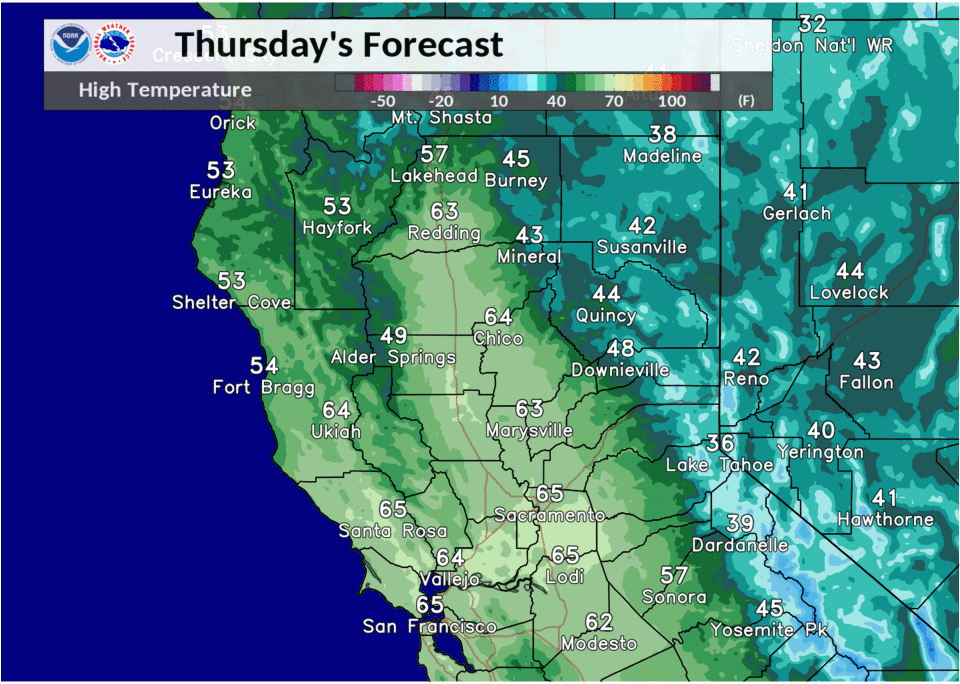
Extended discussion (Monday through Thursday)
Model guidance depicts a weak trough moving into the PacNW on Monday. Precipitation chances are expected to remain near the CA/OR border, but light precipitation may brush the northern mountains and perhaps the northern Sacramento Valley. Tightening surface gradient may lead to increased north to east wind Tuesday into Wednesday morning. The rest of the extended period looks to be dry, with above average daytime highs for early December.