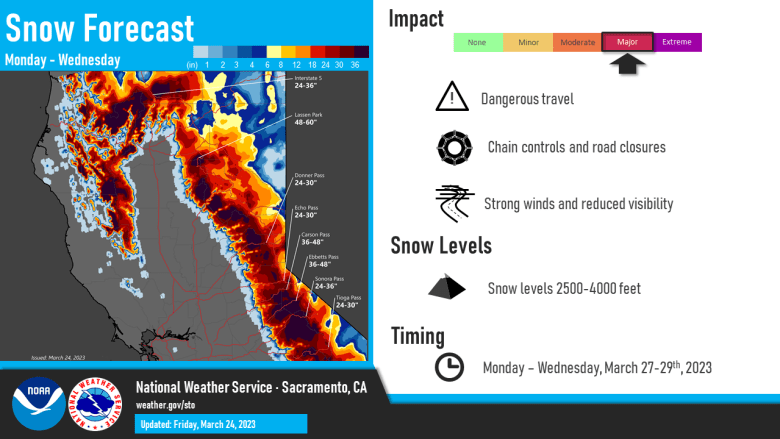
Cool and unsettled weather pattern continues into next week with mainly mountain snow showers. Areas of morning frost will be possible through the weekend. More widespread rain and heavy mountain snow will be possible early next week with the heaviest expected Tuesday.

Discussion
The low is moving east of the area and only a few residual showers remain over the mountains that will be ending this morning. This morning will be chilly with patches of frost possible mainly over the Sacramento Valley and foothills.

Temperatures have been staying up along with the dewpoints(for southern portions of area) so duration this morning is expected to be short for frost formation. Northerly flow will develop over the area with winds mainly between 10 to 15 mph this afternoon and gusts around 20 mph although slightly stronger winds are expected over the northern San joaquin Valley.
On Saturday an inside slider will move into the Great Basin that may produce some showers mainly over the mountains. For the valley it will enhance the northerly flow so would expect breezy conditions during the day with wind gusts between 20 and 30 mph. Wind along with some cloud cover still look likely to reduce frost chances for a lot of the valley Saturday morning.
Sunday will be a dry day and when the coldest morning temperatures are expected. Some north wind over the westside of the Sacramento Valley may limit frost development with the best chances over the eastern side of the Sacramento Valley from around Chico southward expanding to areas from around I-80 southward and the foothills. This time of year fruit plants need to get to 30 degrees or lower to cause damage to most fruit trees. Pear, Plum, Peach, Prunes and Cherry trees need to be at 30 degrees for at least 30 minutes to cause damage. The best chances to reach that will be over the foothills.

Monday a storm system will be approaching and starting to move into the region. Models seem to be in good agreement on timing with light amounts starting to spread over the north ahead of the main front and mainly in the afternoon.
The front will start to spread heavier precipitation Monday night over the entire region.
Extended Discussion (Tuesday through Friday)
Longwave troughing continues along the West Coast early next week as cold upper low drops into it.

Moderate to heavy precipitation possible Monday night through Tuesday along with breezy to windy conditions.

Snow levels lower into the upper foothills.
Latest WPC storm total QPF estimates from Monday through Wednesday night showing around 1 to 2 inches of rain in the Central Valley, highest in the Northern Sacramento Valley.
1 to 4 inches of liquid equivalent expected in the foothills and mountains with several feet of new snow at pass levels.
Vertically stacked system continues south along the CA coast midweek as it begins to fill. Lingering showers possible over the mountains Thursday, otherwise drier weather expected Thursday into Friday as interior NorCal influenced by upper ridging.
