May 4, 2017 – Above normal temperatures continue today then much cooler Friday into the weekend. Increasing threat of showers and afternoon thunderstorms into the weekend, with the best chances over the foothills and mountains.
Short term discussion (Today through Sunday)
Yesterday looks to have been the hottest day this week with some cooling beginning today, especially within the Delta region, as the upper ridge axis shifts east into the Great Basin and onshore flow increases. Hints of the typical summer pattern returns as a Delta Breeze develops and stratus likely returns to the coast. The weakening mid level cap may allow for the development of a few showers and thunderstorms across the mountains in the afternoon into the evening.
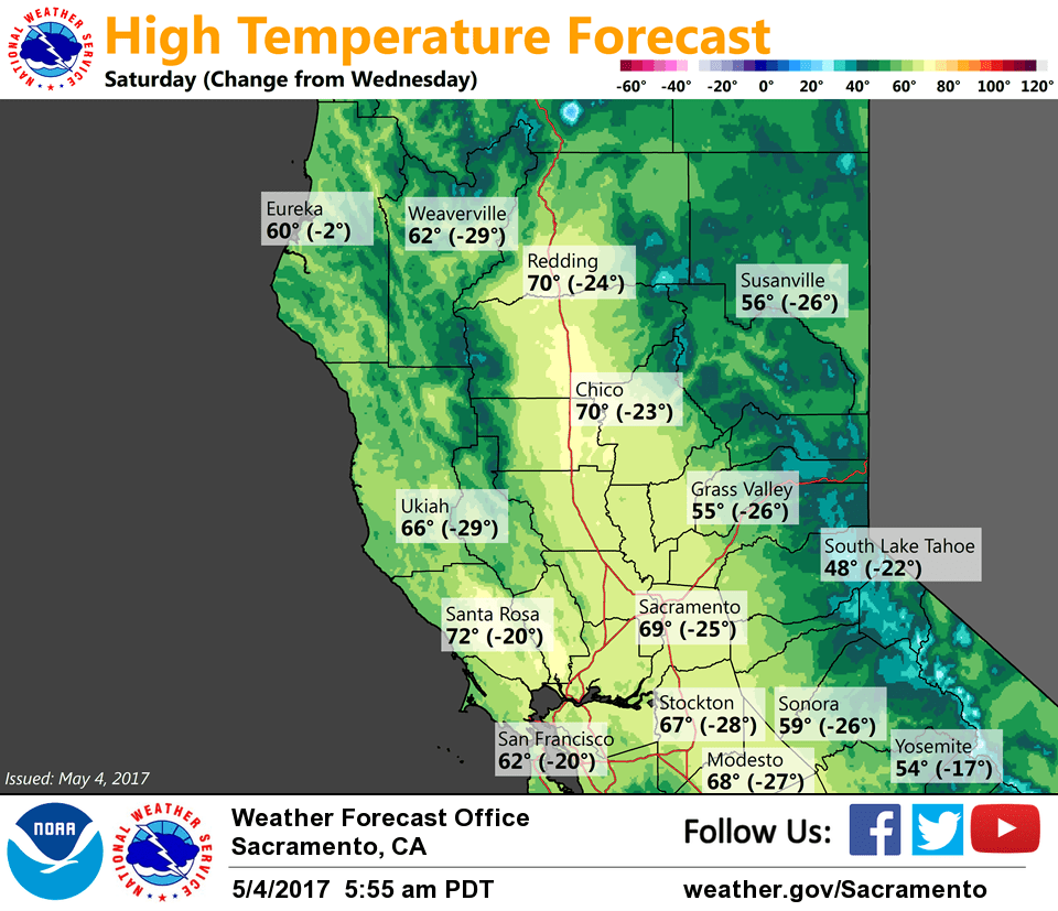
Significant cooling occurs tonight and Friday as onshore flow strengthens and the upper trof moves inside (or East) of 130W Friday afternoon. The marine stratus will likely deepen Friday as the trough nears the coast. Friday will be the first day of the cool air entering into the Central Valley, so do not believe stratus will intrude past Cordelia and I-680 Friday morning. On the other hand, Saturday looks to be the best day for any stratus development/intrusion into the Valley as the dewpoint depressions should be low enough. In addition, the trough will be near the coast, thickening the marine stratus. This will lead to much cooler temperatures on Friday, some 10-15 degrees cooler from Thursday. Further cooling is expected on Sat as low pressure deepens near the CA coast.
Another shot of showers and possibly thunderstorms on Friday and Saturday as cyclonic flow and instability increases over interior NorCal. Confidence is low in areal coverage at this time. Rainfall amounts will mostly be light. The upper low drifts over SoCal Sunday with wraparound flow and limited instability potentially triggering showers mainly over the Sierra and southern Sac and northern San Joaquin Valleys.
Extended discussion (Monday through Thursday)
Model forecasts are in general agreement to an interesting upper level pattern for the start of next week. A lingering upper level low will be positioned over southern California and will continue to spin as it remains cut off from the main upper level flow. A shortwave ridge will be in place somewhere over central California ahead of another larger scale upper level trough approaching towards the middle of next week. With some disturbances lingering, there will be some chances for rain showers for the foothills and mountains and snow for high peaks of the Sierra. Temperatures will be right around normal or a few degrees below normal.