May 24, 2017 – Cooling today into Friday with near to slightly below normal readings by the end of the week. A slow warming trend over the weekend and into next week. Isolated afternoon showers or thunderstorms possible over the northern interior mountains Wednesday and over the northern Sierra Saturday through the middle of next week.
Discussion
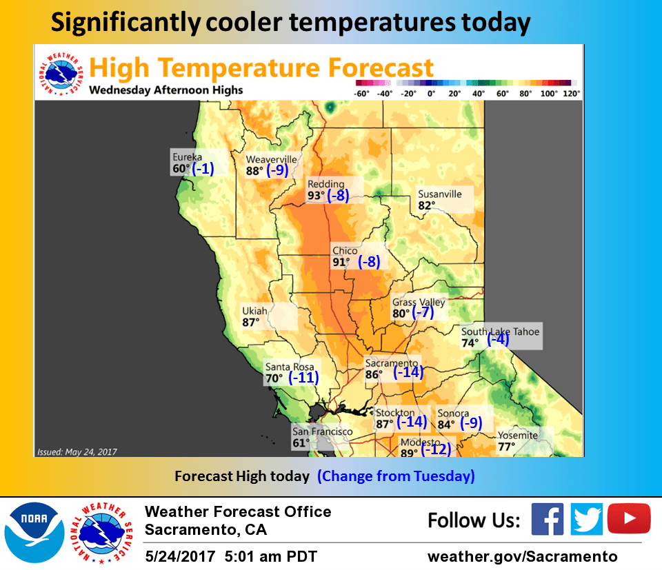
Break down of upper ridge over the west coast will bring significant cooling today on the order of several degrees most areas and as much as 10-15 degrees in delta influenced areas. These areas influenced by the increased delta breeze this morning are currently running a few to several degrees below 24 hours ago. Fort Ord profiler showing the marine layer around 1000 feet or similar to 24 hours ago so not expecting a major marine layer intrusion but may see some minor stratus in the delta.
An upper trough dropping through the Pacific Northwest may produce enough instability for some clouds and isolated thunderstorms over the northern mountains this afternoon and evening but the rest of the CWA will remain under mainly fair skies.
Weak troughing will develop across the west coast on Thursday bringing still more cooling and a continued sturdy delta breeze. Temperatures level off on Friday most areas and are forecast to come in around normal or slightly below for delta influenced areas.
Upper ridging rebuilds over the west coast going into the weekend allowing for a warming trend and a weakening delta breeze. Daytime highs Saturday will pop back up above normal beginning a warming trend extending into next week. GFS shows some moderate mid level instability over the northern Sierra Saturday afternoon so have kept slight thunderstorm threat there for the afternoon and evening hours.
Extended discussion (Sunday through Wednesday)
Strong ridging will remain in place for Sunday into Memorial Day, continuing dry weather and above normal temperatures. Those with outdoor holiday plans should be prepared for the heat.
Highs will top out near the century mark across the northern Sac Valley on Monday with 90s elsewhere in the Valley, and 60s- 70s in the mountains. Delta region will be noticeably cooler thanks to onshore flow and presence of delta breeze.
Ridge flattens out and begins to shift off to the east Tuesday as trough slowly approaches the West Coast for the middle to end of next week. This will allow for a cooling trend with more seasonable temperatures and continued onshore flow. May be enough instability around for isolated thunderstorms across the Sierra and northern mountains each afternoon/evening, but confidence remains low in how widespread activity may be given limited moisture. Therefore, haven’t made major changes to current precip forecast.