June 6, 2017 – Warm and dry weather through the middle of the week. Cooler with a chance of showers for the latter half of the week.
Discussion
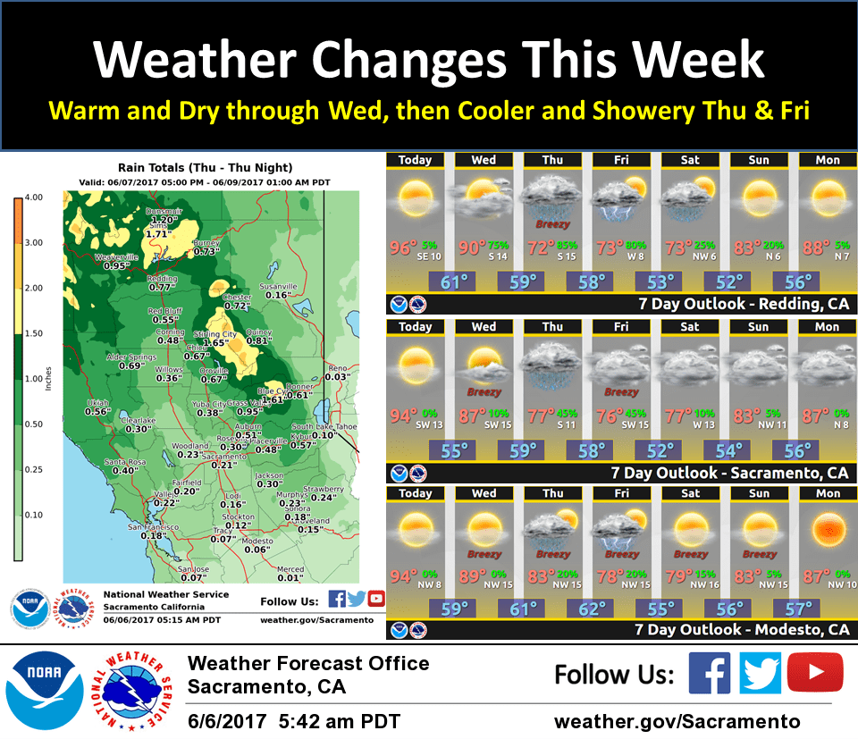
Last day of seasonable 5H heights over Norcal this week according to the standardized 5H height anomaly table before a persistent and relatively deep trof develops over the Western States through the weekend and possibly into early next week. Broad SW flow on the backside of the Desert SW/Rockies ridge and ahead of a progressive trof approaching 140W will prevail over Norcal for one more day. With a shallow marine layer (about 1 kft on the Ft Ord profiler) max temps should continue to run above normal in the Delta influenced areas and over the rest of the CWA today. Max temps some 5-10 degrees above normal are expected over the CWA today, then trending lower on Wed. Weak ripples in the SW flow ahead of the main trof will spread some high level clouds over the CWA at times.
On Wed, the aforementioned trof is forecast to move inside 130W which should initiate a cooling trend. The increasing onshore flow could advect marine stratus inland, mainly during the morning hours. Continued agreement in the GFS/ECMWF keeps confidence relatively high in a cool and wet pattern developing over Norcal on Thu and through the end of the week. The frontal band is forecast to move across our CWA on Thu with precip chances over most of the CWA, to be followed by the upper trof axis on Fri which will keep showers going over the CWA, especially over the higher terrain.
The trof will interact with a +2 to +3 TPW anomaly plume on Thu before it gets shunted Swd on Fri. Given the current QPFs, this could be one of the wettest June 8ths for a few locales. Forecast QPFs of about three-quarters of an inch in the RDD area would make it the 2nd wettest June 8th, while a quarter inch at DTS would make it the 3rd wettest, and an inch and a half at BLU would threaten the wettest there.
Thunder chances look limited on Thu at this time as the thermally indirect circulation of the upper jet remains NW of our CWA. This could change later in the week as the colder trof axis moves over the region with mid level CAA steepening lapse rates, and in addition to orographic effects.
Common to Australia, it is time for a “Cool Change” with max temps on Thu some 10-17 degrees below normal over the Nrn half of the CWA (N of I-80) and 5 to 9 degrees below normal over the Srn portion of the CWA (S of I-80), and again some 10-17 degrees below normal CWA-wide on Fri.
Extended discussion (Saturday through Tuesday)
The final shortwave finally moves through NorCal Saturday as the longwave trough exits east Saturday night into Sunday. However, model guidance indicates some uncertainty on the strength of this wave, as the ECMWF favors a northerly track compared to the GFS. Regardless, the best dynamics might be limited to the far northern mountains and Sierra north of I-80. Dry conditions and increasing temperatures are expected early next week due to a building ridge.