May 7, 2021 – Dry weather continues with increased north winds and elevated fire weather concerns over the weekend. Cooler today, then warming trend into next week.
Widespread gusty north to east wind expected Saturday, which persists into Monday afternoon. Combined with low humidity and dry fuels will increase critical fire weather conditions over lower elevations. Strongest wind expected along the west side of the Sacramento Valley and through favorably oriented gaps and canyons in the surrounding foothills. Lighter wind expected Tuesday, but dry and hot conditions continue.
Discussion
Satellite imagery shows a few high clouds across NorCal ahead of upper trough as it approaches the region. The onshore pressure gradient maxed out Thursday afternoon and is beginning to wane as surface high pressure builds into far northern California (MFR-RDD gradient is around 8 mbs). Still seeing some southwesterly gusts of 20-30 mph in the west Delta and across the higher elevations of the northern Sierra, while local southerly gusts in the teens mph are present through the southern half of the Sacramento Valley.
Trough axis moves through early this morning, then the transition to northerly/northeasterly surface flow will accelerate. Today will be the coolest day for awhile with highs in the Central Valley only expected to reach the lower 80s.


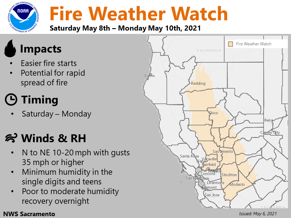
NorCal will be on the backside of the evolving western US trough over the weekend with tightening northerly surface gradient and northwesterly flow aloft supporting an extended period of gusty winds. The winds are expected to peak across most of the region on Saturday with gusts of 30-40 mph across the Central Valley. Sunday will be breezy too, but likely not quite as strong except along the western edge of the Sacramento Valley.
Relative humidity values will also be extremely low this weekend with Valley locations expected to drop into the single digits. Poor overnight recoveries will also be seen.
Due to these winds, low RH values, and dry fuels, elevated fire weather concerns will be seen throughout the weekend into early next week. A Fire Weather Watch has been issued beginning late tonight and early Saturday. Avoid using outdoor equipment that could create a spark and obey local burn bans.
The return of warmer temperatures is also expected this weekend as upper level ridging moves back over Northern California as valley highs return to the upper 80s and lower 90s.

Extended discussion (Tuesday through Friday)
EPAC upper ridge axis remains dominant synoptic feature over interior NorCal Tuesday through Thursday continuing dry weather with above normal temperatures. High temperatures expected to be 10 to 20 degrees above normal. Ensembles show upper trough towards the end of the week, but vary with strength. Main impact at this time appears to be increased onshore flow with some synoptic cooling Friday.