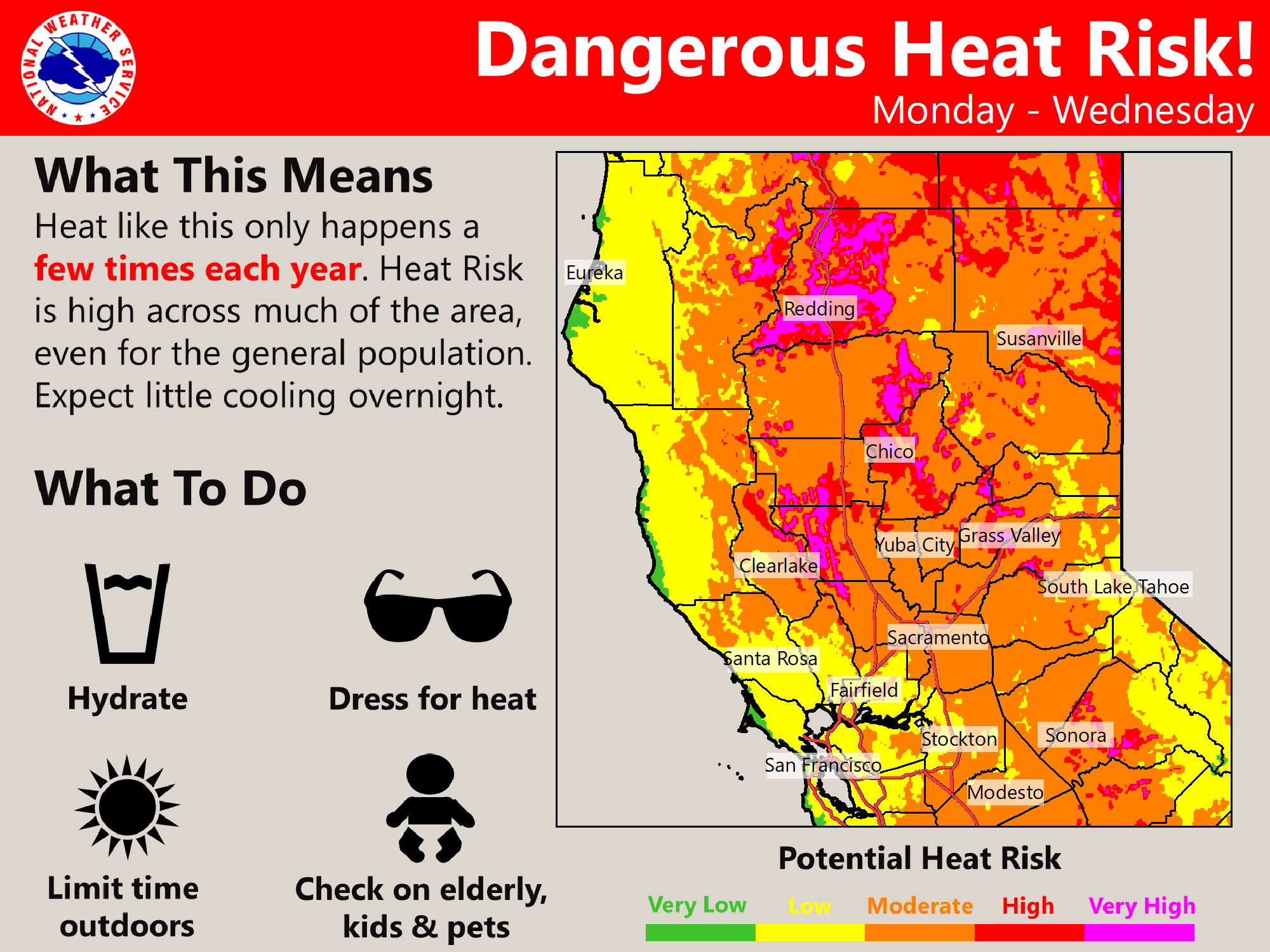
Strong high pressure will continue hot weather this week, particularly for the northern half of the Sacramento Valley and surrounding terrain. Slight chance of late day thunderstorms returns to the Sierra beginning Monday.
Discussion
Skies remain nearly cloud-free across interior NorCal early this morning as very strong high pressure remains centered to the north over the PacNW. Surface pressure gradients have strengthened between the coast and Central Valley resulting in breezy winds through the Delta and locally into the southern Sacramento Valley. While stratus remains extensive along the coast and throughout the Bay Area, profiler data show that the marine layer remains quite shallow with cooling effects not quite as much as 24 hours ago. Current temperatures are very mild and range from the upper 50s in the Delta and coolest mountain valleys, to the mid 70s to mid 80s across the most of the Central Valley and many foothill and mountain thermal belts.
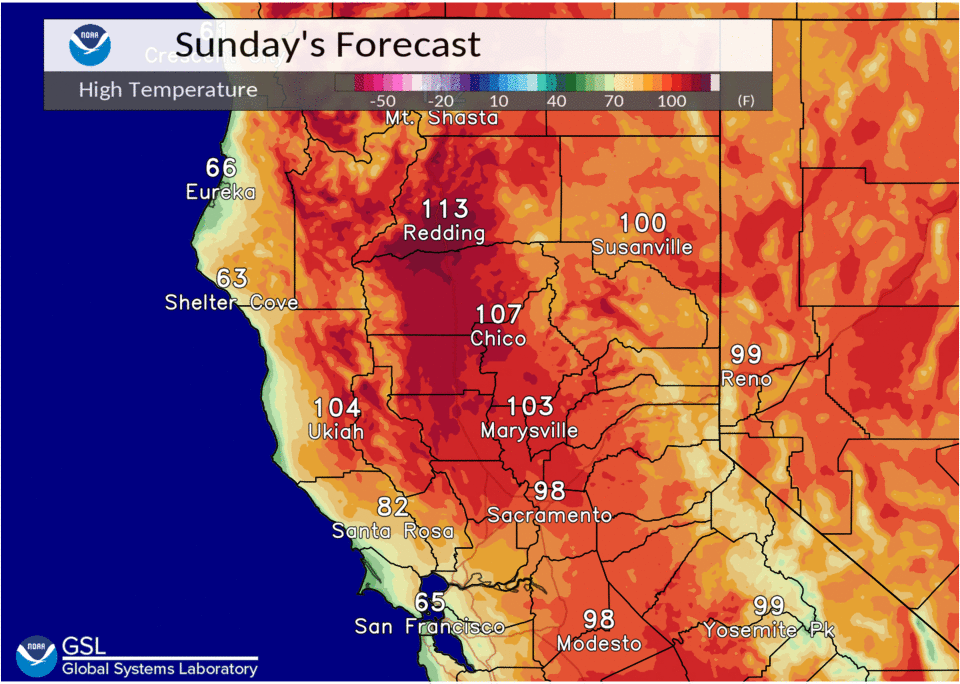
Another hot day is in store for the region as it remains on the periphery of the high over the PacNW. Most areas will see temperatures similar to Saturday’s, though the Sacramento Valley may see a few degrees of cooling as southerly flow develops earlier in the day as the offshore low edges a bit closer. Despite that, daily record highs will once again be in jeopardy across the northern Sacramento Valley (Redding’s record high for today is 111 from 1918, and Red Bluff’s is 109 from 2003).
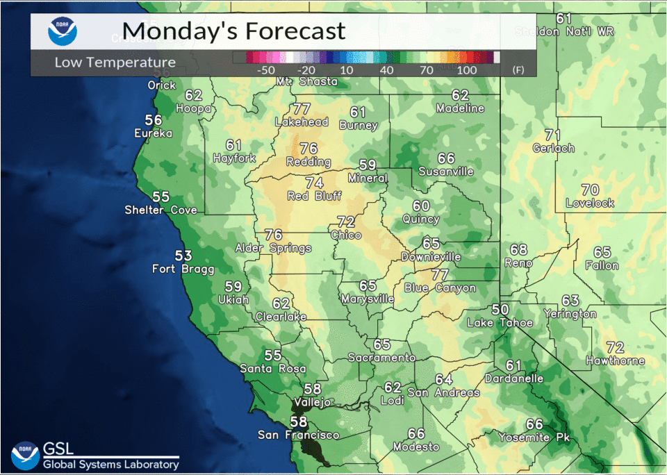
High pressure will weaken a bit early this week, but hot weather will persist with highs of 105-110 expected to continue across the northern Sacramento Valley through mid-week. Overnight lows will also remain very mild with 70s to lower 80s.

Just enough onshore flow is expected to keep the edge off the heat for the Delta and Sacramento/Stockton areas where highs will remain in the 90s to around 100 with lows in the 60s.
Strong subsidence and warm mid/upper level temps will again inhibit deep convection over the mountains today, and over most of the region on Monday. Perhaps an isolated late day storm may develop Monday in the Sierra over the far southeast corner of the forecast area. Potential for storms to spread a little further north in the Sierra on Tuesday and Wednesday as the cap weakens and mid/upper flow backs to a more southerly/southeasterly direction.
Extended discussion (Thursday through Sunday)
Upper high over the Intermountain West is main synoptic feature through the extended forecast period. This will continue above normal daytime temperatures with widespread triple digit heat in the northern, and portions of the central, Sacramento Valley. Models suggest anticyclonic flow around upper high could advect some moisture over the Sierra Nevada leading to potential for deep moist convection resulting in possible afternoon showers or thunderstorms over higher terrain.