May 25, 2017 – Cooling continues into Friday with near to below normal temperatures. Slow warming trend this weekend into early next week. Isolated afternoon showers or thunderstorms possible over the northern Sierra through the weekend. Afternoon thunderstorm threat spreading to northern mountains early to middle of next week.
Discussion
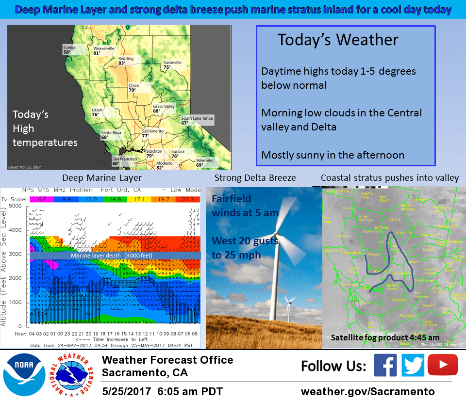
Upper trough axis now stretching across northern California has deepened the marine layer to near 3000 feet this morning. Delta breeze continues strong with gusts to over 30 knots at Travis AFB. Marine stratus has already moved through the delta with patchy low clouds being reported at the Sacramento airport. Much of the Sacramento region will likely wake up to low clouds this morning.
Meanwhile, just about all areas seeing cooler temperatures this morning with stations in the central Sacramento and northern San Joaquin valleys showing over ten degrees of cooling compared to Wednesday morning. Cooler airmass will bring still cooler high temperatures today down to near or a little below normal for this time of year.
Upper troughing remains across northern California on Friday so not expecting much change in overall temperatures or marine layer with morning stratus likely again through the delta and Sacramento region. GFS and NAM models both showing some instability over the northern Sierra in the afternoon and evening hours with GFS painting in some precipitation south of about Tahoe. Will therefore keep a slight threat of afternoon and evening thunderstorms in the forecast for this region.
Upper ridge pushes back over the west coast on Saturday bringing the start of a warming trend. Lighter onshore flow and a squashed marine layer will likely keep morning stratus from making it past the delta. GFS showing some instability over the northern Sierra in the afternoon and evening so left in slight threat of thunderstorms there. Warming continues on Sunday under upper ridging.
Daytime highs are likely to reach several degrees above normal. Enough southerly flow and instability to keep afternoon thunderstorm threat over the northern Sierra.
Extended discussion (Monday through Thursday)
Hot weather continues into early next week as strong ridging remains over the area. Highs for Memorial Day will top out near the century mark across the northern Sac Valley, low to mid 90s elsewhere in the Valley and 60s-70s in the mountains. Those with outdoor plans should prepare accordingly for the heat! Tuesday will also be hot, perhaps a degree or two warmer than Monday. Ridge begins to break down and shift to the east by Wednesday as a weak trough approaches the West Coast. This will start a cooling trend that may continue through the end of the week. Enough instability present each afternoon/evening for a few thunderstorms to fire across higher elevations. Have continued to mention in the forecast but confidence remains low given subtle model differences at this time.