March 28, 2017 – Dry and milder weather expected for NorCal through most of Wednesday. Another system will brush the region late Wednesday through Thursday with a few showers. Dry and warmer weather returns for the weekend.
Discussion
Upper ridge is moving onto the West Coast with mainly clear skies across interior NorCal early this morning. Current temperatures generally range from the mid 20s and 30s in the mountains to the 40s and lower 50s elsewhere.
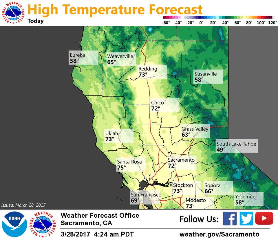
Dry and milder weather is expected over the region today and Wednesday with temperatures returning to around average or a little above. Breezy northerly winds will continue today across the Central Valley before decreasing tonight.
The next weather system is forecast to approach the region Wednesday night before sliding southeast into the Great Basin on Thursday. It is expected to bring light QPF to mainly the mountains, though eastern portions of the Central Valley will see the best chance for a few showers Thursday. A few inches of accumulating snow is expected across the higher elevations of the northern mountains and northern Sierra.
Dry and breezy weather expected to return Friday as the system shifts further to the east and high pressure rebuilds over the area.
Extended discussion (Saturday through Tuesday)
High pressure rebuilds across Northern California on Saturday, bringing a rapid but brief warming trend. High temperatures are expected to be on the order 10, possibly 15 degrees warmer than normal.
Longer range models continue to struggle with the details as a trough breaks down the ridge. The ECMWF is much faster, with a system brushing by far northeastern NorCal on Sunday. The GFS and GEM bring a splitting trough to the region Monday. Neither scenario is particularly wet. Given the low confidence forecast, we made little change to the forecast.