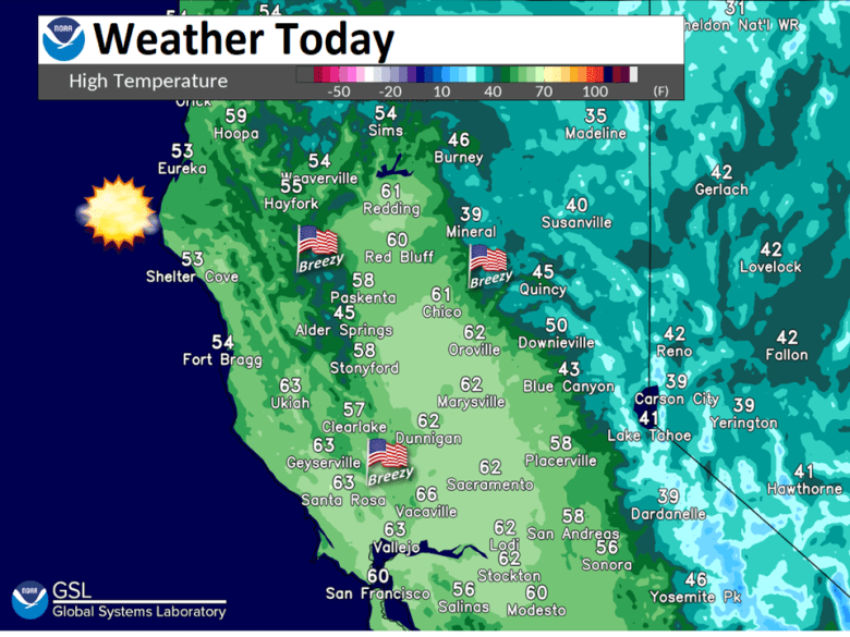
Dry weather with some periods of breezy north to east wind. Below normal high temperatures, except near normal midweek. Chilly nights with some frost possible.

Discussion
Upper low center near KTPH this morning and progged to continue a SEly track as upstream short wave ridging moves into the CWA. 24 hr changes showing cooler temperatures in the Sacramento valley attm under clearing skies and lowering dewpoints. This could allow for some patchy frost this morning in wind sheltered areas of the Sacramento Valley. Further south, temperatures running warmer and dewpoints higher, which could allow for some patchy mist or light fog development in the Northern San Joaquin Valley.
All this will be short lived as N-S surface pressure gradient over interior NorCal trending up attm and KDAX wind profiler showing about 35 kts of northerly wind at 2K ft above the surface. Stronger wind aloft will mix to the surface later this morning for some areas of breezy northerly wind in the Central Valley and Delta.

High temperatures today expected in the lower 60s across interior NorCal with mid 60s in the Delta where downslope off the Vaca mountains will enhance surface heating. Wind in the Central Valley decreases tonight as boundary layer decouples. Low level gradient will continue areas of gusty NE-E wind in the eastern foothills and mountains.

Lower dewpoints will allow for greater longwave radiational cooling in the Central Valley overnight. This could lead to more widespread frost Monday morning.
Next upper low progged down the CA coast Monday into Tuesday. This feature appears to be lacking significant moisture to produce any precipitation. High temperatures Monday expected to be near to slightly cooler than today under minor synoptic cooling.

Some locally breezy wind possible Monday in the Northern Sacramento Valley. Low moves south of the area Tuesday turning flow aloft offshore over NorCal. N-S surface gradient progged a little stronger Tuesday in the Central Valley while areas of gusty wind continue Monday night/Tuesday morning in the northern and eastern foothills/mountains.
High temperatures Tuesday in the Central Valley trend up several degrees over Monday. Areas of gusty N-E wind will continue Tuesday night into Wednesday morning in the northern and eastern foothills/mountains. Upper high moves south to off the CA coast Wednesday warming AMS over interior NorCal.
High temperatures Wednesday expected to return to near normal with mid to upper 60s in the Central Valley and 40s to 50s for the foothills and mountains.
Extended Discussion (Thursday through Sunday)
Ensembles and clusters show upper level ridge over NorCal from Thursday into the weekend. This will keep dry weather and near normal temperatures over the region through next weekend.
