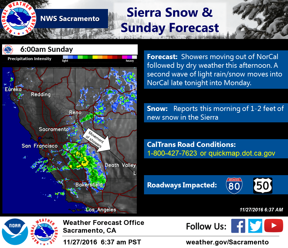
November 27, 2016 – This weekend’s storm continues to bring snow to the Sierra this morning but should move out of our region this afternoon. A second system moves into NorCal late tonight into Monday with drier conditions on Tuesday.
Morning update
Light snowfall was still occurring for some mountain locations south of Highway 50, but short term HIRES guidance has indicated the threat for additional large accumulations of snow has ended. As a result, the Winter Weather Advisory and Winter Storm Warning has been cancelled. However, slippery mountain pass roads and chain controls may still be affecting travel today.
Discussion
At 4 am, radar imagery showed that the remaining showers of the current storm are near and south of the Interstate 80 corridor from the Bay Area over to the Sierra. Chain controls and traffic delays continue to impact Sierra travel down to around 3500 feet, especially on I-80 and Highway 50. Any holiday travelers today should check with CalTrans before going over the Sierra as the Winter Storm Warning remains in effect through 10 am.
The HRRR and NAM models still indicate that the bulk of showers should push southeastward this morning with precipitation dissipating by late morning/early afternoon. Conditions should improve between 10 am to noon.
Interior NorCal will see a break this afternoon and evening before the next wave of precipitation moves inland late tonight into Monday morning. This second wave won’t have as much moisture and any additional snow accumulation should be light, up to 1 or 2 inches above 3500 feet. Rain amounts in the valley will also be light at about a tenth of an inch or less. After showers end on Monday, our region will see a period of dry weather through Tuesday night. Temperatures across the forecast area will remain near normal in the 50s for the Valley/foothills and 30s/40s for higher elevations.
Models indicate that another weak wave could bring light precipitation to NorCal on Wednesday. Once again, this should be a light system and showers are expected to stay mainly at the higher elevations with a slight chance in the northern Sacramento valley.
Extended discussion (Thursday through Sunday)
GFS and ECMWF dig upper low from Pacific Northwest into the Great Basin on Thursday. Cyclonic flow over Sierra may allow for a few showers over the crest through Thursday evening while rest of CWA remains dry. Daytime highs Thursday will remain a little below normal before a warming trend begins Friday as high pressure pushes over the state. Warming continues on Saturday with daytime max temperatures climbing to a little above normal at the end of the week. Remainder of next weekend remains dry as upper ridge flattens.