April 11, 2021 – Dry, warm, and breezy conditions through the weekend and into early next week. Slight chance for light mountain showers over the Sierra on Tuesday and Wednesday.

Discussion
Aside a few high clouds passing over the northern San Joaquin Valley, GOES-West infrared imagery shows mostly clear conditions over central and northern California this morning. Building upper level ridge just west of the California coast brought synoptic- scale warming to much of the Golden State on Saturday, and will maintain the well-above normal temperatures into early next week. Look for highs today to peak in the low/mid 80s for Valley communities.
In addition to the above normal temperatures today, surface high pressure in Oregon will result in a northerly pressure gradient over the Sacramento Valley. Latest check on the the Sacramento to Medford gradient as of 06Z Sunday was at -10.1 mb, and it is forecast to peak around -11 to -12 mb.
Simply put: the stronger the gradient, the stronger the winds. The wind-prone areas of the Sacramento Valley will see gusts max out in the 20 to 30 mph range this morning through the early afternoon, with isolated higher gusts possible.
The east-west gradients — as measured from Reno to Sacramento — don’t appear to be as noteworthy over the next 12 to 18 hours, therefore, wouldn’t expect widespread gusty winds in the Sierra/foothills outside the usual wind-prone gaps/passes.
A renewed push of breezy north to east winds will impact the region again Sunday night and into Monday. At this point, gusts in the Sacramento Valley appear to be similar as the day before, while winds in the mountains appear to be a bit stronger. That said, forecast wind gusts still remain below advisory criteria. Monday afternoon will remain dry and warm with highs returning to the low/mid 80s.

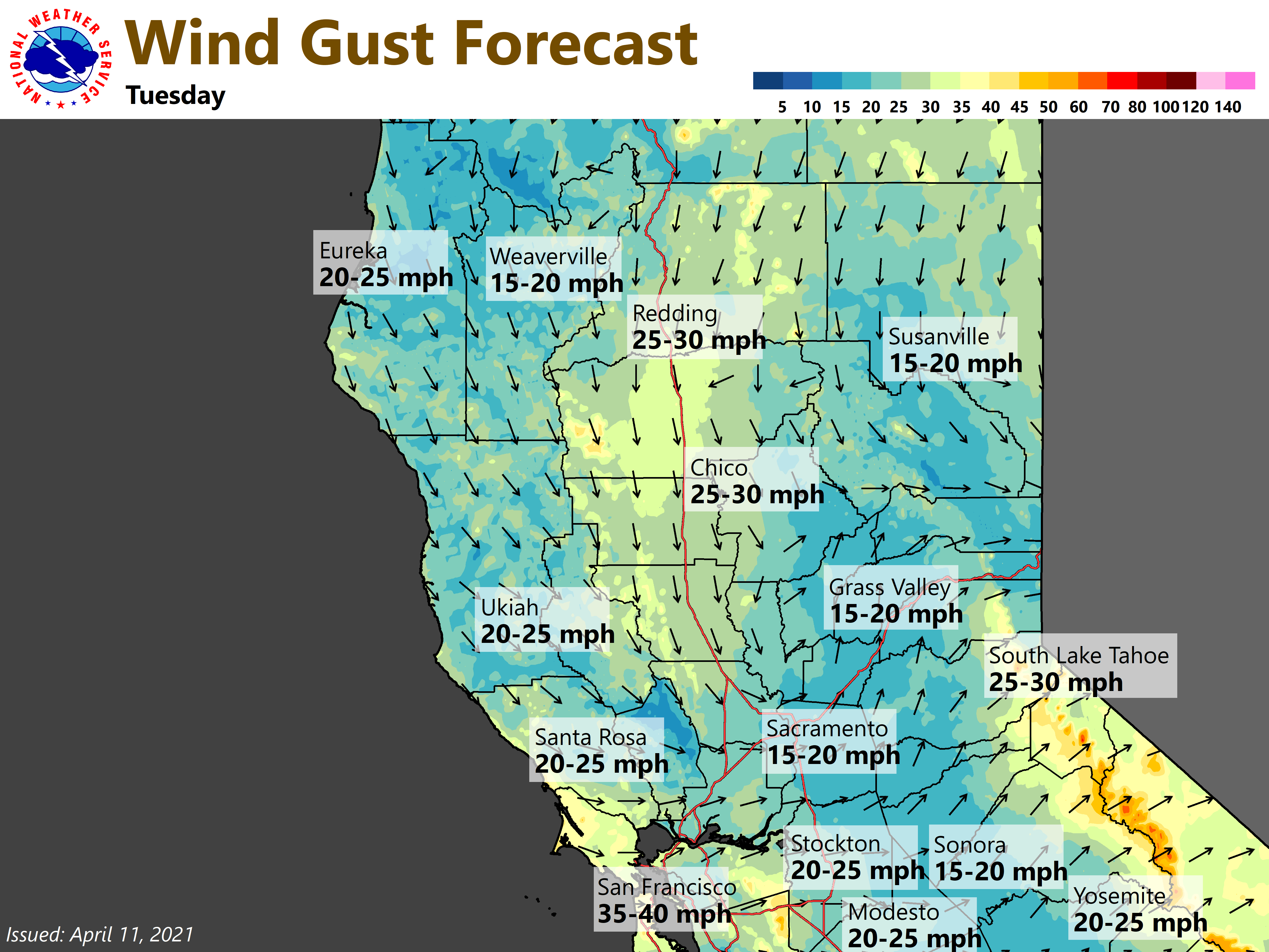
An energetic shortwave will drop south from the Pacific Northwest on Tuesday, and will help maintain the offshore wind pattern for the region. Additionally, can’t rule out the chance of mountain/foothill showers during the afternoon/evening hours.
While there is some uncertainty with respect to winds and precipitation chances, there is solid confidence temperatures will drop back by at least several degrees. Ensemble guidance has the shortwave evolving to a cut-off upper low over the Great Basin around Wednesday and beyond.
Oh a cut-off low, a forecaster’s woe…
Extended Discussion (Thursday through Sunday)
Large double-barreled 551 DM upper low continues to meander over the Great Basin Thursday with embedded weak waves rotating cyclonically around it through NorCal. Available moisture is limited to hinder precipitation development.
Low weakens and progresses Friday with upper col moving over CWA. Lower confidence in forecast over the weekend with divergent model solutions. Attm will keep the weather dry. Warming trend expected through the extended forecast period with highs 10 to 15 degrees above normal.