Dry and warmer weather this week. Locally gusty westerly winds over the Sierra today with locally breezy northerly winds on Thursday. Cooling trend begins this weekend with the potential for a pattern change next week.
Discussion
Satellite imagery shows the upper trough moving into NorCal as the strong ridge has been nudged east into the northern Rockies. Other than a few high clouds, skies remain clear across the region. Surface pressure gradients have begun to trend toward onshore as the strong offshore gradient from early Tuesday has weakened. The marine layer remains very shallow (less than 500 ft in depth) with stratus limited to the immediate coast. Current temperatures are very mild and range from the mid 60s to upper 70s across the Central Valley, around 5-15 degrees warmer compared to 24 hours ago.

The dry trough moves through today bringing a few degrees of cooling to most areas (850 mb temperatures drop 1-2 degrees). The system will bring gusty southwest winds to the higher elevations of the northern Sierra where gusts of 20-30 mph will be possible (locally higher in wind prone areas).

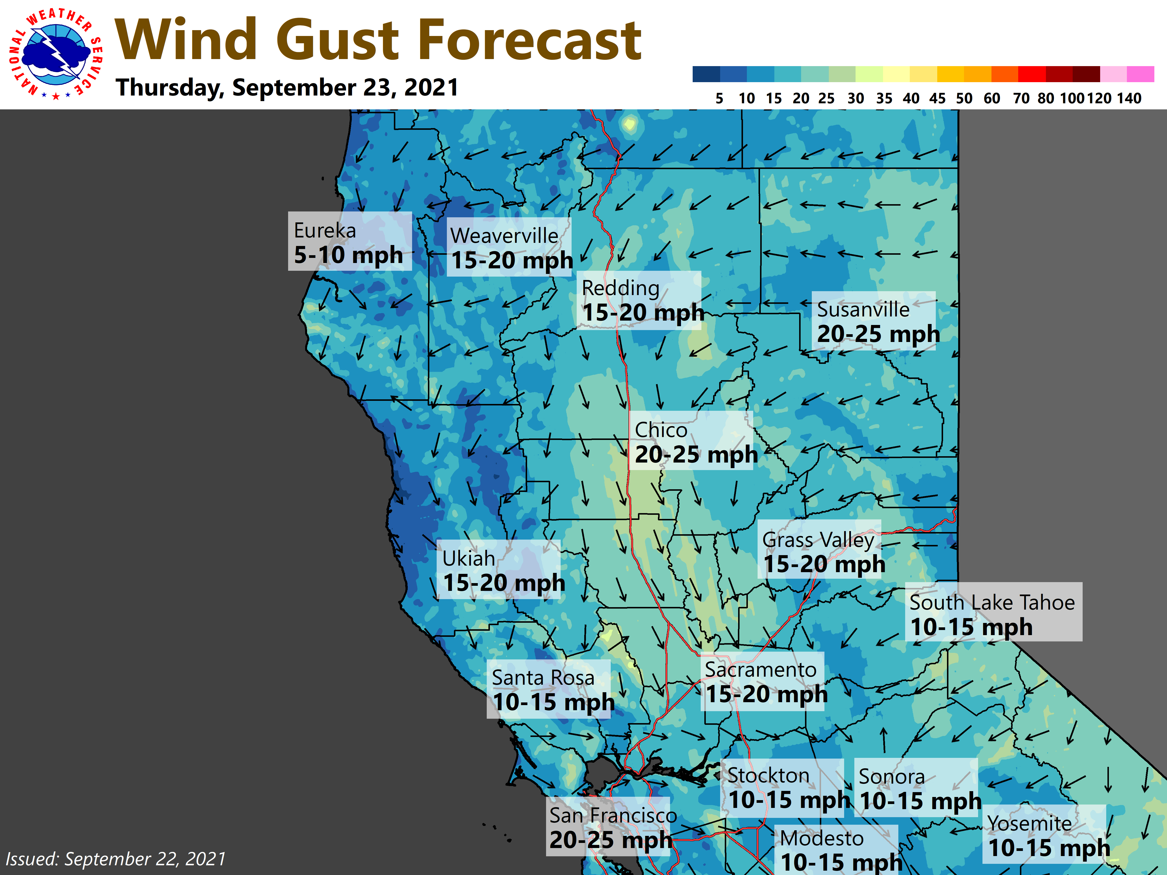
Another episode of breezy north to east winds is expected over NorCal late tonight and Thursday on the backside of the system as it drops south through the Great Basin and eventually closes off over SoCal at the end of the week. Gusts of 20-30 mph will be possible in the Sacramento Valley and near favored wind-prone locales on the west slopes of the northern Sierra and southern Cascades. The combination of gusty winds and dry conditions will result in elevated fire weather conditions.
Warm and dry conditions, with less wind, are expected Friday and Saturday as high pressure covers the area.
Extended Discussion (Sunday through Wednesday)
Models trending even farther south with closed upper low Sunday as it works its way into the Desert SW. Upstream Pacific frontal system progged to move through interior NorCal early next week. Models differ with depth and progression of this system, but agree in the front weakening as it moves onshore. Following NBM for now with a threat of precip, mainly over the Coastal Range, Shasta and Plumas counties Mon into Tue. Main impact will be additional cooling with below normal high temperatures. Oper GFS closes upper trough over NorCal Wed keeping a threat of showers. EC,EPS/GEFS, and forecast attm, supports a drier more progressive solution midweek.