September 5, 2020 – Dangerous, record-breaking heatwave will impact the region through the Labor Day weekend and into next week.
Critical fire weather concerns will return late Monday night through early Wednesday with north Valley winds and downslope east winds over the foothills.

Smoke and haze from wildfires will continue to impact air quality.
Discussion
Main weather concern in the near term will be record breaking heat wave Labor Day weekend through Tuesday.
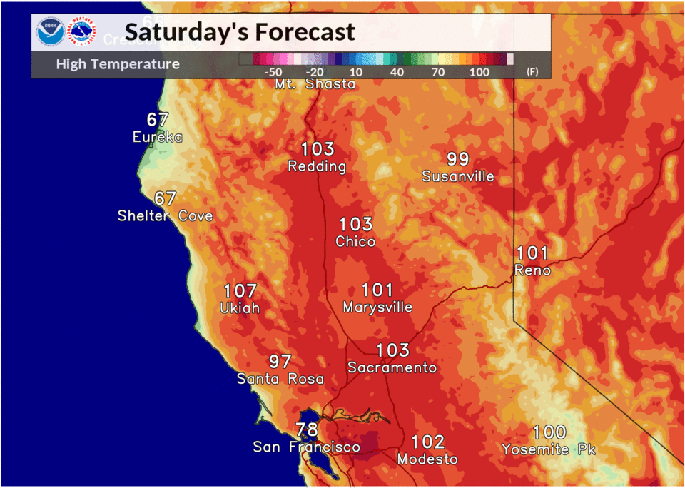
Temperatures are expected to be from from 15 to 20 degrees above normal during this timeframe. High temperatures today will generally be from 100 to 105 at Valley locations. High temperatures are forecasted to approach or even exceed 110 degrees at Sacramento, Stockton and Modesto Sunday. These readings would break all-time September high temperatures records for these locations.
Also low temperatures are expected to be very warm only cooling into the 70 to 80 degree range.

Hot conditions continue Monday and Tuesday with Valley high temps from 105 to 110 degrees. These extreme temperatures will cause dangerous heat impacts and an excessive heat warning will continue through Tuesday.
There is the potential for very high heat risk during this time, which could impact the general population, especially those spending an extended time outdoors.
Euro and GFS are in good agreement with track of trough dropping south through the eastern Great Basin and Rockies late Monday and Tuesday.
Within this pattern a strong surface high pressure system dropping south from Montana into the central Rockies will create a strong gradient between surface low pressure off the the northern California coast late Monday through Wednesday.

Currently expecting 15 to 20 mph north valley winds and east downslope Sierra and foothills winds with gusts up to 30 mph. Local gap wind gusts could reach 50 mph in isolated favored topographical spots such as Jarbo Gap.
These winds combined with very dry conditions will create critical fire weather conditions Late Monday through Wednesday and a Fire weather watch is in effect.
Extended discussion (Wednesday through Saturday)
Hot and dry pattern continues later next week as GEFS and EC ensemble maintain a strong ridge over NorCal. Temperatures will remain well above average with lighter winds than earlier in the week.