August 30, 2017 – Brief respite from the excessive heat today, then very hot weather returns with record highs likely later in the week and through the Labor Day Holiday weekend. Excessive Heat Warning from noon Thursday to 8 PM Monday.
Discussion
Elevated moisture and instability continues to interact with the incoming trough resulting in some sprinkles across Tuolumne County early this morning, otherwise skies are clear across the region. Temperatures are cooler compared to 24 hours ago through much of the Central Valley due to the return of onshore flow, while readings are still mild at the north end of the Sacramento Valley and over the mountains. Current readings range from the mid 40s in the colder mountain valleys to around 80 across the milder portions of the valley and foothill thermal belts.
Showers chances will continue in the Sierra to the south of Lake Tahoe this morning before the moisture and instability is shunted eastward in the afternoon by the incoming trough. There may still be an isolated thunderstorm across the far southeast corner of the forecast area during the afternoon.
While still hot, temperatures will be a bit cooler today due to the combination of synoptic cooling associated with the trough and continued onshore flow.
Hotter weather returns Thursday as strong ridging from the eastern Pacific begins to build into NorCal. Northerly low-level flow also returns cutting off the Delta Breeze. Most areas expected to see a 4-8 degree bump in temperatures compared to what’s forecast today.
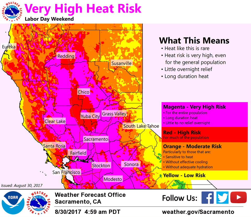
Excessive heat is really forecast to crank up across NorCal on Friday and Saturday. Most of the Central Valley is forecast to be in the 110-115 degree range with northerly flow continuing as the ridge is forecast to be centered to our north. Overnight lows will also be very mild with thermal belt areas only expected to see temperatures drop into the lower 80s. The heat watch has been upgraded to a warning with significant heat-related impacts expected through the weekend into at least early next week.
Extended discussion (Sunday through Wednesday)
We’re in for another round of very hot weather over the weekend and into next week as strong high pressure dominates NorCal. Residents with outdoor plans for the Labor Day holiday weekend, should ensure that they limit exposure to sun, stay cool, and drink plenty of water. Widespread 103-110 daytime highs across the valley from Sunday into Tuesday. Overnight lows will stay fairly warm as well, especially in thermal belt regions across the foothills. Valley and foothill lows will be in the low to upper 70s early Monday morning…in the upper 60s to low 70s on Tuesday & Wednesday mornings.
High pressure will remain dominant through much of the extended forecast with slight weakening possible by middle of next week. However, that weakening of the high will probably only result in a cooling of only a few degrees…leaving much of the valley still in triple digit heat. Slight chance of mountain thunderstorms at times during the extended forecast.