
August 26, 2017 – High pressure strengthens over the western US this weekend and lingers into early next week. Temperatures will trend upward, with widespread triple digits in the Valley today through Tuesday. Hottest days will be Sunday and Monday (100°-110°). Upgraded the Heat Advisory to an Excessive Heat Warning for Sunday into Monday due to the potential for greater impacts. Those who are sensitive to heat should take extra precautions. Slight cooling by mid-week but highs will remain above normal. Triple digits may return for the holiday weekend.
Discussion
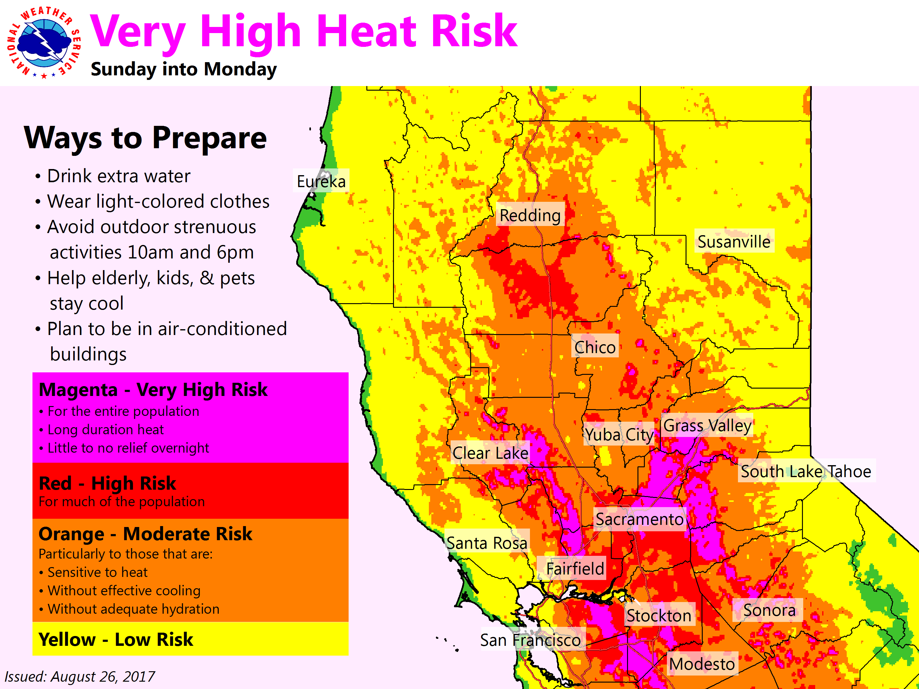
Warming returns to the region as ridge of high pressure over the Great Basin expands into NorCal. This will bring stable conditions, above normal highs, and generally light winds with limited onshore flow. With 850 mbs temps in the mid to upper 20s deg C, temperatures are expected to be as much as 10-13 degrees above normal for this time of the year. Another long duration heat event is expected this weekend into early next week, with widespread triple digits across valley locations. High temperatures are forecast to be around 100-110, hottest across the northern Sacramento valley.
Latest model guidance has continued to trend warmer so have nudged temperatures upward. In addition, overnight lows will offer limited relief since temperatures will only cool down into the upper 60s to 70s over the valley and foothills given limited onshore flow and a compressed marine layer. Moreover, the latest Heat Risk values indicate the potential for moderate to high heat risk across much of the Central valley. This will increase the potential for heat-related illness, especially for sensitive groups. Therefore, have upgraded the Heat advisory to an Excessive Heat Warning and included the northern Sacramento valley as well.
Extended discussion (Tuesday through Saturday)
Tuesday will begin a slight cool down as a weak weather system approaches the Pacific Northwest, and flattens the upper ridge. Cooling is relative as temperatures will remain above normal, but most locations will be at or just below the century mark in the southern and central Sacramento valley Wednesday and Thursday. This system will also bring a weak delta breeze, but will be limited to the Vacaville/Fairfield areas. Not much cooling will be experienced from this limited breeze elsewhere in the valley. This timeframe will also bring a return to monsoon moisture to the Sierra Nevada range and points east. At this time, most of activity looks to be in Nevada, but outdoor enthusiasts should monitor the forecast as this may change. By the end of the week, into the holiday weekend, it does look as though the ridge re intensifies, bringing another round of triple digits to the valley. Keep track of the forecast if you have outdoor plans for the holiday weekend.