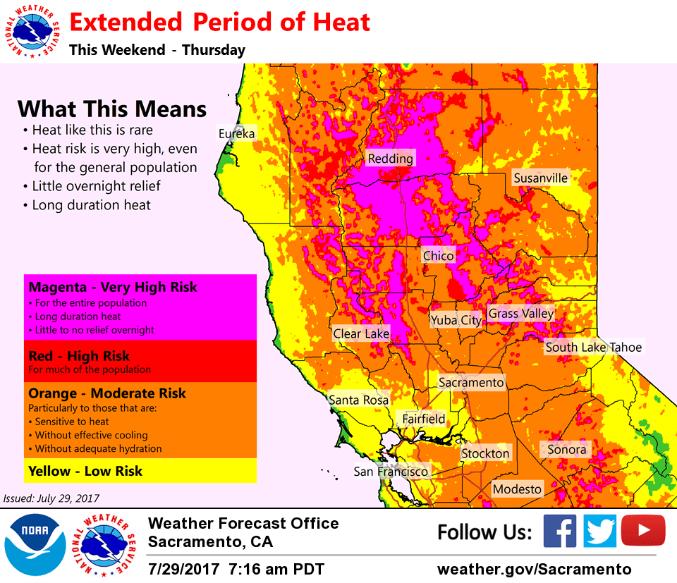
July 29, 2017 – Heatwave persists into next week with Tuesday being the hottest day. Isolated afternoon or evening thunderstorms possible near the Sierra crest this weekend. Excessive Heat Watch from Monday afternoon through Thursday evening.
Discussion
Not much change to the short term forecast as our region heats up under a strengthening high pressure system. We’ve still got a bit of a Delta Breeze blowing into interior NorCal today which will temper warming. However, daytime highs will be 3-7 degrees above normal with valley highs in the upper 90s for delta influenced areas and 100-105 degrees elsewhere. The Delta region will range low 80s to low 90s. Foothill regions will be in the 90s while higher elevations are in the mid 70s to upper 80s.
Temperatures will continue to rise by several degrees each day in the short term forecast as the delta breeze weakens under the building high pressure. On Sunday, highs will range 5-10 degrees above normal…Monday at 7 to 13 degrees above normal and Tuesday will be 10-15 degrees above normal. Peak of this heatwave is expected on Tuesday when valley highs could range 103 up to 114 near Redding while the Delta is generally in the 90s…higher elevations should range 100-105 in the foothills and mid 80s to upper 90s above the foothills.
Overnight lows will gradually warm each night during this heatwave. Minimum temperatures will still dip into the 60s tonight and Sunday night, but then creep upward towards the 70s Monday night with widespread 70s by Tuesday night. Excessive Heat Watch still in effect for the Valley and surrounding foothills beginning Monday afternoon and continuing into the extended period (Thursday at this point). The risk for heat- related illness will increase heading throughout the week as the heat continues.
Isolated thunderstorm activity still possible along the Sierra crest Saturday (today) and Sunday afternoons, but expect most of the activity to stay on the eastern side of the crest.
Extended discussion (Wednesday through Saturday)
Heatwave continues through late next week as strong high pressure persists over the West. Peak of the heatwave will be Monday thru Wednesday when highs may reach 110-115 across the northern Sacramento Valley and heat watch remains in effect. There will be enough onshore flow to moderate temperatures in the Delta and southern Sacramento Valley. Increasing chance for mountain thunderstorms and possibly even some elevated convection elsewhere by mid-week as monsoon moisture spreads northward.