June 16, 2017 – Continued Warming today going into an extended heat wave this weekend and into next week. Widespread highs over 100 degrees and warm nights in the valley this weekend and next week. Isolated thunderstorms possible over the Sierra Sunday through Tuesday.
Discussion
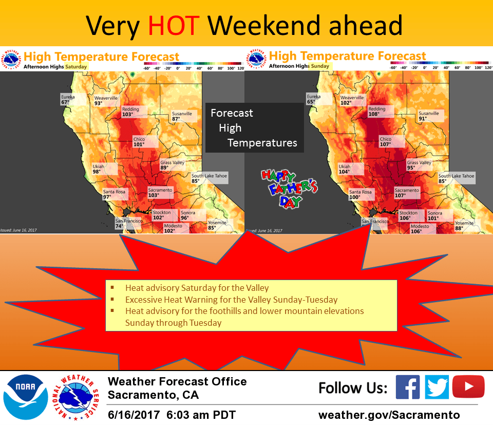
Fair skies over the CWA this morning under flat high pressure although a few high clouds may stream across the north as a shortwave moves through the Pacific Northwest. Airmass warming continues today with highs climbing a few to several degrees over Thursday. Today max temperatures are expected to come in between 10 and 15 degrees above normal. GFS and NAM showing some afternoon convective precipitation over the northern Sierra south of Tahoe. MU cape from GFS showing significant instability mainly to the southeast of the CWA. Westerly flow aloft will likely keep any afternoon convection east of the crest so kept pops at ghost level less than 15 percent for today. Upper ridge axis amplifies over the eastern Pacific on Saturday bringing still more warming. With max temperatures in the valley forecast to be between 102 and 106, have kept heat advisory in place for the valley. Higher elevations still not quite there however so will delay the advisory for a day above 1000 feet. Instability and isolated precipitation still showing up over the northern Sierra but upper westerly flow should still keep convection east of the crest.
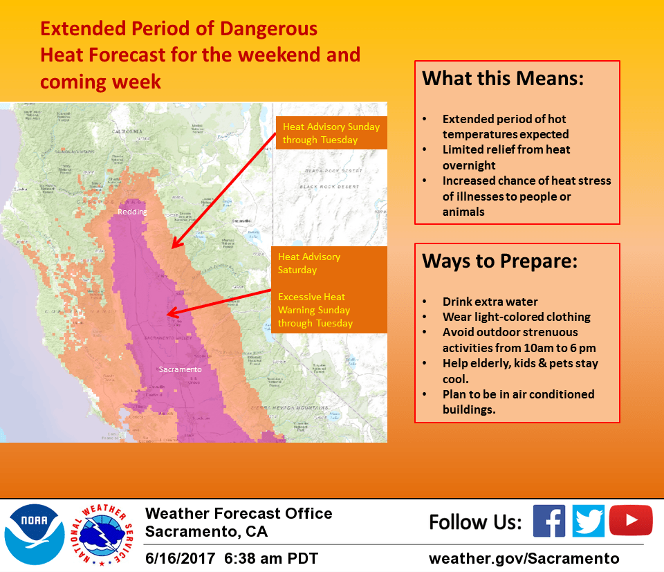
Warm up continues on Sunday as the upper ridge axis shifts inland over the west coast. Highs Sunday throughout the valley are forecast to range between 105 and 110 degrees or close to record numbers. This puts the valley into excessive heat warning territory and have issued an excessive heat warning for the lower elevations starting Sunday afternoon. Higher elevations up to about 5000 feet will see temperatures warranting a heat advisory and have continued the heat advisory already in existence here. With upper ridge axis shift to east of the state, upper flow becomes southeast. As a result, afternoon thunderstorm threat over the Sierra crest and west becomes more likely. Little change in forecast for Monday as upper ridging only shifts slightly. With upper southeast flow, have kept in slight afternoon thunderstorm threat over northern Sierra. High temperature advisories and warnings remain in place going into the extended.
The table below offers the record maxes at our main climate sites for this weekend.
Mod RBL RDD DTS SAC SCK
17th 103 109 104 102 103 103
18th 104 109 102 105 102 104
Extended discussion (Tuesday through Friday)
Upper level ridging continues to dominate next week, though gradually weakens mid to late week as a trough from western Canada flattens the pattern.
The hottest day of the heat wave is expected to be on Tuesday. Daily record or near record highs are forecast across the area. Tuesday morning lows are expected to very warm, though a light Delta breeze could bring a little cooling in nearby influenced areas. Northerly winds in the northern Sacramento Valley and adjacent foothills could keep temperatures from dropping below the mid to upper 70s in those areas.
A Heat Warning has been issued which continues into Tuesday below 1000 feet, with a Heat Advisory into the foothills and lower mountains. Temperatures on Wednesday look just a couple degrees lower, with a bit more cooling on Thursday. Friday is expected to be the last day of triple digit highs, though even the weekend currently looks like above normal temperatures will continue.
Instability and moisture in the Sierra south of Highway 50 and Lassen park area could bring a few afternoon thunderstorms Tuesday afternoon. Otherwise, the extended period looks dry.
North winds are expected, particularly breezy on Wednesday and Thursday. This along with low humidity levels will bring heightened fire weather concerns through the extended period.