June 18, 2017 – An extended heat wave continues through most of this week with widespread highs over 100 degrees and warm nights. Isolated afternoon thunderstorms possible near the Sierra Crest from around Lake Tahoe and southward for Sunday and Tuesday, spreading into the northern mountains for Monday.
Discussion
Near record temperatures are expected to continue until Thursday as high pressure ridging with a very hot airmass continues to dominate across the southwestern US.
Northerly winds gusting up to 20-25 mph are keeping overnight temperatures elevated, as well as increasing fire danger. At 3 am, temperatures were were generally 4 to 9 degrees higher than this time yesterday. The breezy downsloping northerly winds were keeping Vacaville at a remarkable 90 degrees at 4 am, 18 degrees higher than 24 hours ago! Records for high minimums may well fall today, as well as some afternoon highs. The good news is that lows this morning may be the warmest of the week, and then gradually become slightly more comfortable through the rest of the week.
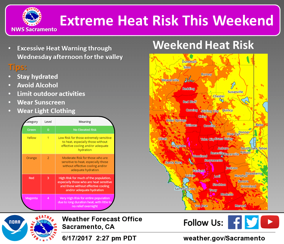
Father’s Day activities outdoors today will likely be greatly impacted by the heat. An Excessive Heat Warning begins this afternoon for the Valley and Delta, and has been extended through Thursday. This extended period of extreme heat with little relief overnights will create a dangerous situation. Precautions against heat exhaustion should be taken, especially for sensitive groups such as the elderly. The Heat Advisory for the foothills and lower mountains has also been extended until Thursday.
Breezy northerly winds gusting to 20-30 mph today along with low humidity levels will bring critical fire weather conditions to the Valley. Any fires that develop will likely spread rapidly, especially in thick, cured grasses. A Red Flag Warning continues to be in effect until 9 pm this evening for the Valley into southern Lake County.
Some limited cooling is expected for Delta breeze influenced areas potentially on Monday, more on Tuesday. This will be noticed the most in the Vacaville area, extending through the Delta and nearby locations. Locations further away will see little change in overnight lows, though. A shallow marine layer means that the cooling will be limited, so temperatures will still be quite warm, with most locations remaining in the 70s, and even around 80 in the foothill thermal belt areas.
Some afternoon and evening thunderstorms are possible today from the Sierra crest around Lake Tahoe southward. Monday afternoon and evening could see this spread to the higher northern mountains and Lassen Park area as a weak shortwave moves in. Drier weather is expected Tuesday and Wednesday, though can’t rule out isolated thunderstorms near Yosemite Tuesday afternoon.
Extended discussion (Thursday through Sunday)
Strong ridging forecast to remain in place along the West Coast through the extended period maintaining hot and dry weather across the region. A very weak trough toward the end of the week may lead to minor cooling inland with more substantial cooling in the Delta and southern Sacramento Valley for a few days as onshore flow increases, though lots of uncertainty in the timing and strength of a potential Delta Breeze that far out.