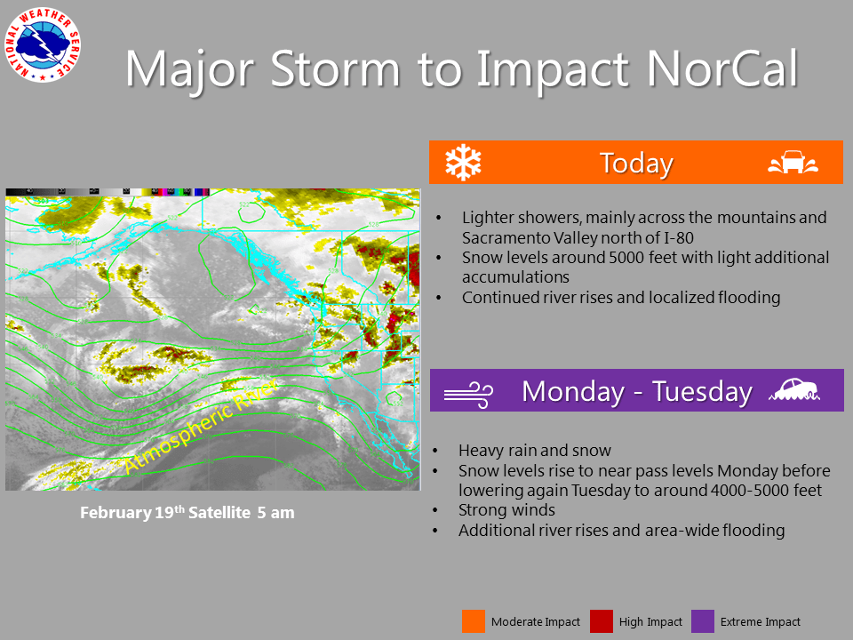
February 19, 2017 – Main message for interior NorCal is that residents should be prepared for flooding, heavy snow, and wind damage. Wet pattern continues across the region through Wednesday, with the wettest storm expected Monday and Tuesday. R
Wet weather with renewed flooding concerns into the middle of next week with wettest storm of the bunch expected for Monday through Tuesday. Gusty winds likely again Monday. Mountain travel will also be impacted at times due to heavy snow. Valley thunderstorms possible Tuesday and Wednesday.
Discussion
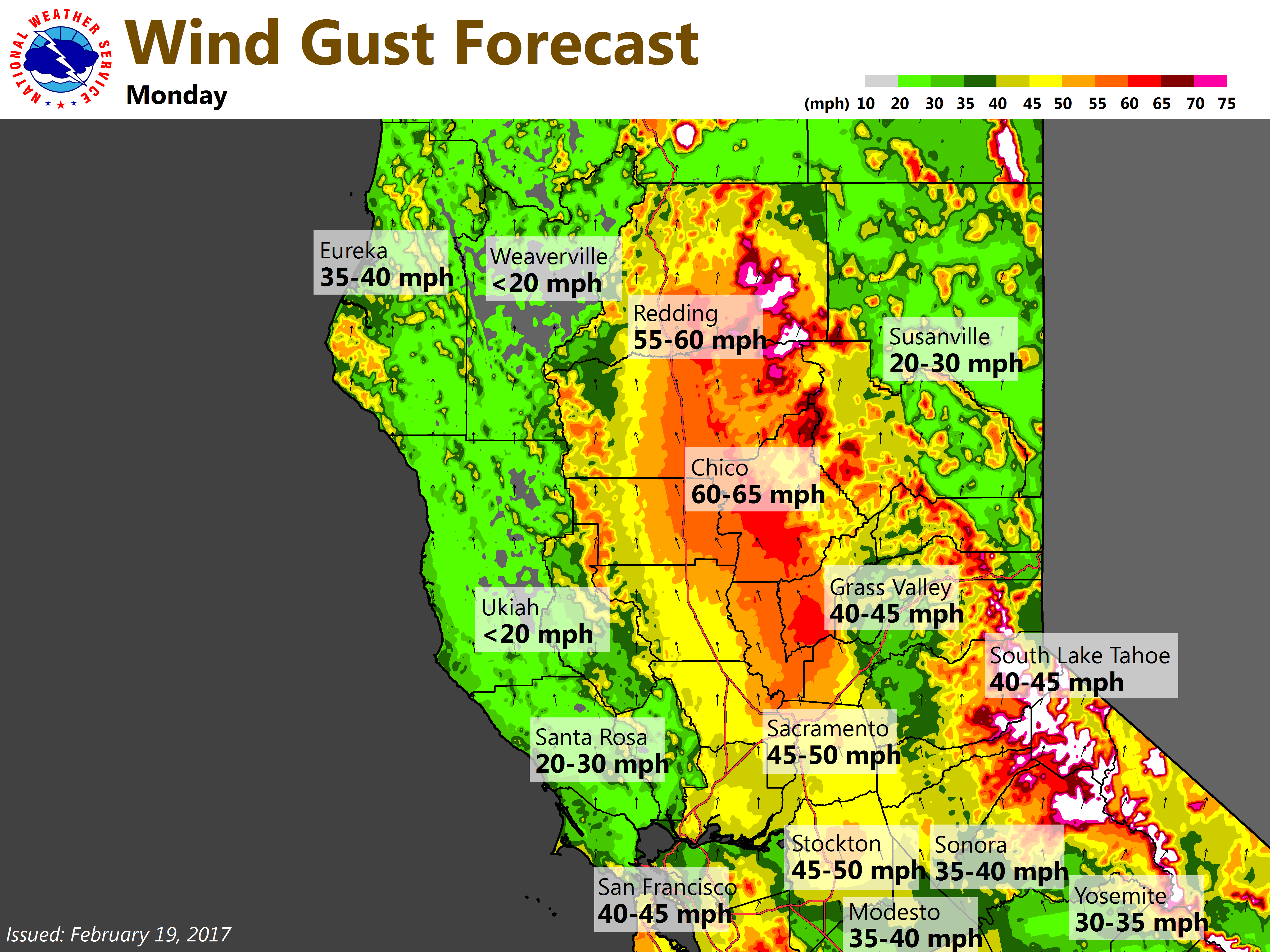
Large upper level trough in the northeast Pacific will continue to impact NorCal weather over the next several days. A shortwave disturbance pivoting through central California this morning in southwest flow ahead of the trough is bringing light rain to the Sacramento and Delta area this morning. A 6 mb surface gradient from Redding to Sacramento is bringing breezy winds to the northern Sacramento valley this morning with sustained winds between 20 and 25 mph north of about Chico.
Have issued wind advisory through today for this area as model guidance keeps this level of winds going through the day. Snow levels this morning range from about 3500 feet northern Shasta county to 5000 feet over the northern Sierra. Snowfall amounts should be relatively light today although chain controls are still in affect for the major Sierra passes. More light showers expected this afternoon as another shortwave disturbance pivots through, this time a little farther north.
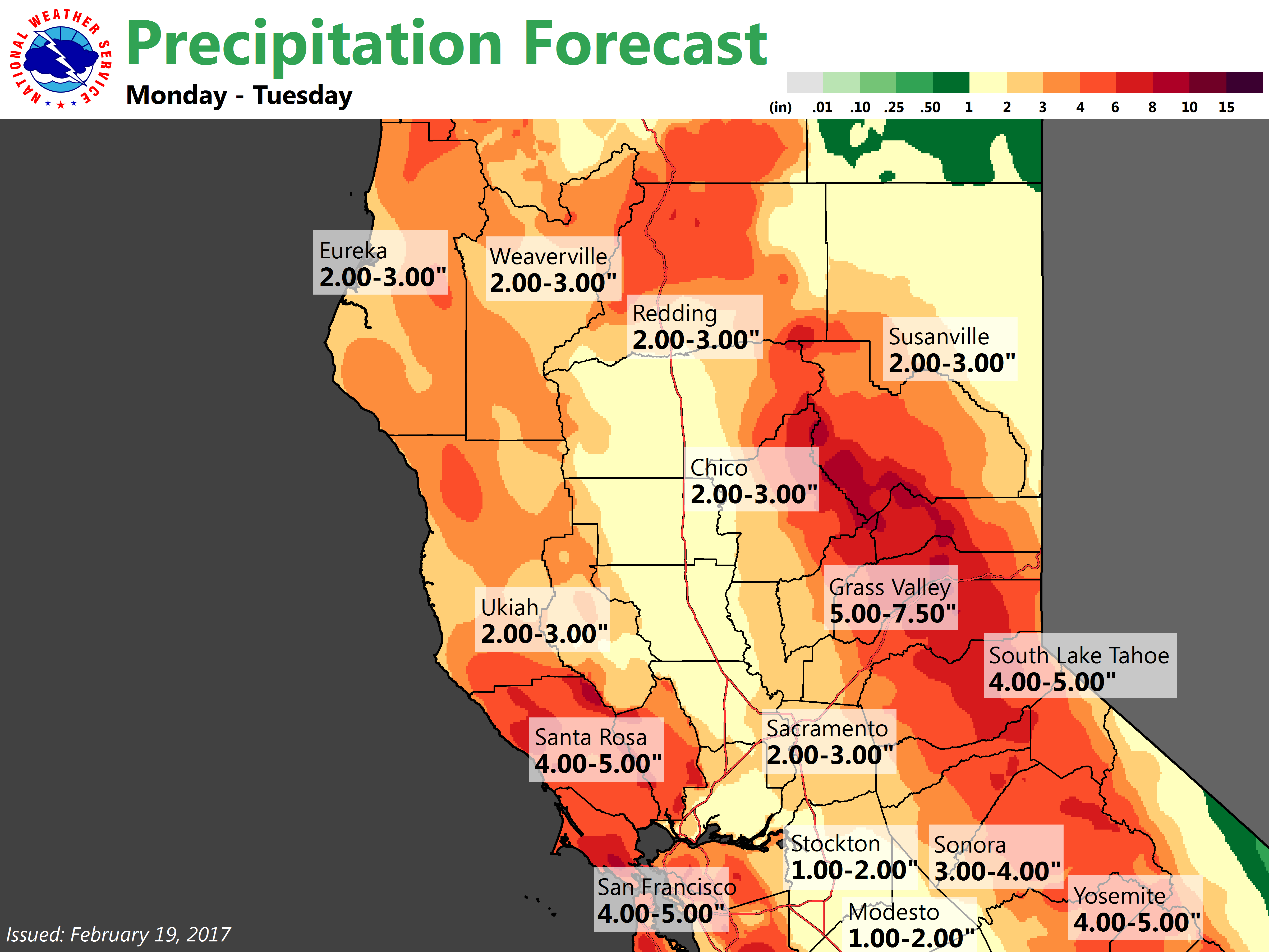
Things begin to ramp up this evening as a much stronger and wetter Pacific storm system moves onshore. Widespread moderate to heavy rain and snow are expected with gusty winds as this atmospheric river weather system moves through. The blended total precipitable water satellite product shows PW values of and inch and a half within the river with locally even higher values. This is a return interval in the 5-10 year range. Precipitation amounts max out during the day on Monday. Between tonight and Monday night, 1 1/2 to 2 1/2 inches of rain are forecast for the valley and orographically favored areas of the Sierra west slopes could see up to 8 inches of rainfall during this time. Snow levels during this time will climb to about 7000 feet but are still likely to be low enough to continue to impact pass level travel over the Sierra.
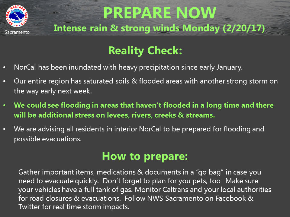
Rainfall will likely create even more flood issues during and after Monday. A flood warning will remain in place for interior Norcal through much of the week. Winter storm warnings have been issued for the Sierra Cascade range. As if this is not enough, evening stronger winds are expected Monday evening as the main frontal band shifts through with 925 nb progs from the NAM showing over 55 mph winds. This will likely produce another round of power outages as soggy ground allows even more trees to topple on powerlines. Focus of heaviest rainfall continues to shift southward. Heaviest rainfall still likely over the American river basin and now southward so needed to increase QPF south of the 80 corridor from previous forecasts.
Precipitation drops off on Tuesday behind the main front as do winds but snow levels drop as colder air filters in so a larger area of Sierra will be impacted by snowfall. Have extended the winter storm warning through Tuesday evening.
Main upper trough shifts through on Wednesday keeping the showers going and bringing down snow levels even farther but precip amounts should be relatively light. Snow levels could be down to 3000 feet by Wednesday evening. Cold air aloft that brings down the snow levels will also destabilize the atmosphere so it is likely that the valley will see isolated afternoon and evening thunderstorms Tuesday and Wednesday.
Extended discussion (Thursday through Sunday)
Thursday into Friday is expected to be mainly dry as short wave high pressure ridging moves in, with just some lingering mountain and foothill showers. Any precipitation is expected to be light. Northerly winds should limit fog formation, moist low level conditions could allow some fog/mist to develop in sheltered areas.
Extended models are trending towards a wetter scenario for late Friday through Saturday night. Models previously were showing a less wet scenario, and disagree on the track of a low which is dropping down from western Canada. If the latest GFS is correct, this cold be a rather wet system, though quite a bit less than the early week system. If the ECMWF and GEM are correct, there could be some precipitation, but not a large amount. Sunday there is a relative lull in the wet weather, with mainly mountain precipitation. This may a brief lull, with yet another system expected on Monday, showing no significant break in the wet pattern.