December 6, 2016 – Cold overnight temperatures again tonight. A return to wetter weather is expected Wednesday through Saturday. Freeze Watch from late tonight through Wednesday morning for Central Sacramento Valley-Clear Lake/Southern Lake County- Motherlode-Northeast Foothills/Sacramento Valley-Northern Sacramento Valley-Northern San Joaquin Valley-Southern Sacramento Valley.
Discussion
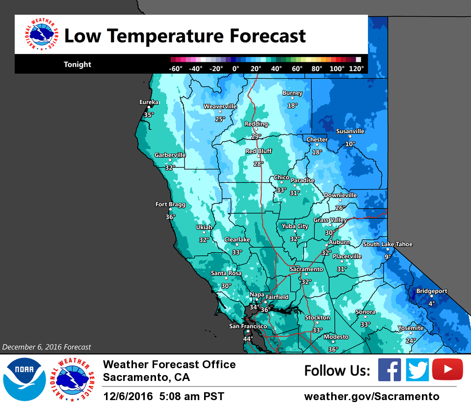
Clouds are moving out of the region as the latest frontal system pushes south. With generally light winds, areas of frost and patchy fog have developed in the Central Valley. Temperatures are running colder north of Sacramento where skies have been mostly clear overnight while readings are milder across the northern San Joaquin Valley. Current temperatures are in the teens and 20s in the mountains and in the 30s across the Sacramento Valley with lower 40s around Stockton and Modesto.
Another weak system brushes across NorCal today and will bring some light snow showers to the northern mountains and northern Sierra Nevada. Skies will clear tonight, and temperatures will likely be the coldest of the season so far.
At this time, widespread morning lows around the freezing mark are expected in the Central Valley with some of the colder spots dipping into the upper 20s. The durations at or below freezing should not exceed several hours for most locations. Mountain valley lows will get very cold dipping into the single digits and teens. There looks like high clouds drifting over the region by Wednesday morning should help to mitigate the low temperatures and prevent them form dipping colder than freezing in many places.
The cold morning lows will be short lived as a stronger, more significant system moves into the region Wednesday night into Thursday. Snow levels should be low to start Wednesday night but rise on Thursday to near or just above pass levels by mid to late morning. The focus of where the heavier precip will occur into Friday continues to vary depending on which model you examine with the GFS remaining generally the wettest.
Nevertheless, appears transition back to a wetter pattern for NorCal commences late this week.
Extended discussion (Saturday through Tuesday)
Unsettled pattern looks to continue through much of the extended period. Model solutions diverge from Friday night with the ECMWF showing an additional wave of precipitation, perhaps substantial, during the day Saturday, while GFS remains mostly dry outside a few Sierra showers. Given such a large difference, have hedged toward a blend of solutions with precipitation over most of the area, until solutions are better aligned. Snow levels may drop lower with this wave should it occur which would further impact weekend mountain travel.
Next wave moves across the area late Sunday or overnight with a more subtropical influence. The GFS is much wetter with this wave vs the drier ECMWF. Regardless, looks like best chance for widespread precip across the area comes Monday and Tuesday. Snow levels around 3500 feet across northern mountains and 4500 to 5500 feet in the Sierra on Monday, then increasing into Tuesday with the warm air advection.