May 7, 2017 – Cooler with a chance of mountain showers and thunderstorms today with gusty north winds. Turning warm again early next week. Wind Advisory until 4 PM this afternoon for Central Sacramento Valley-Clear Lake/Southern Lake County-Mountains Southwestern Shasta County to Northern Lake County-Northern Sacramento Valley-Southern Sacramento Valley.
Discussion (Today through Wednesday)
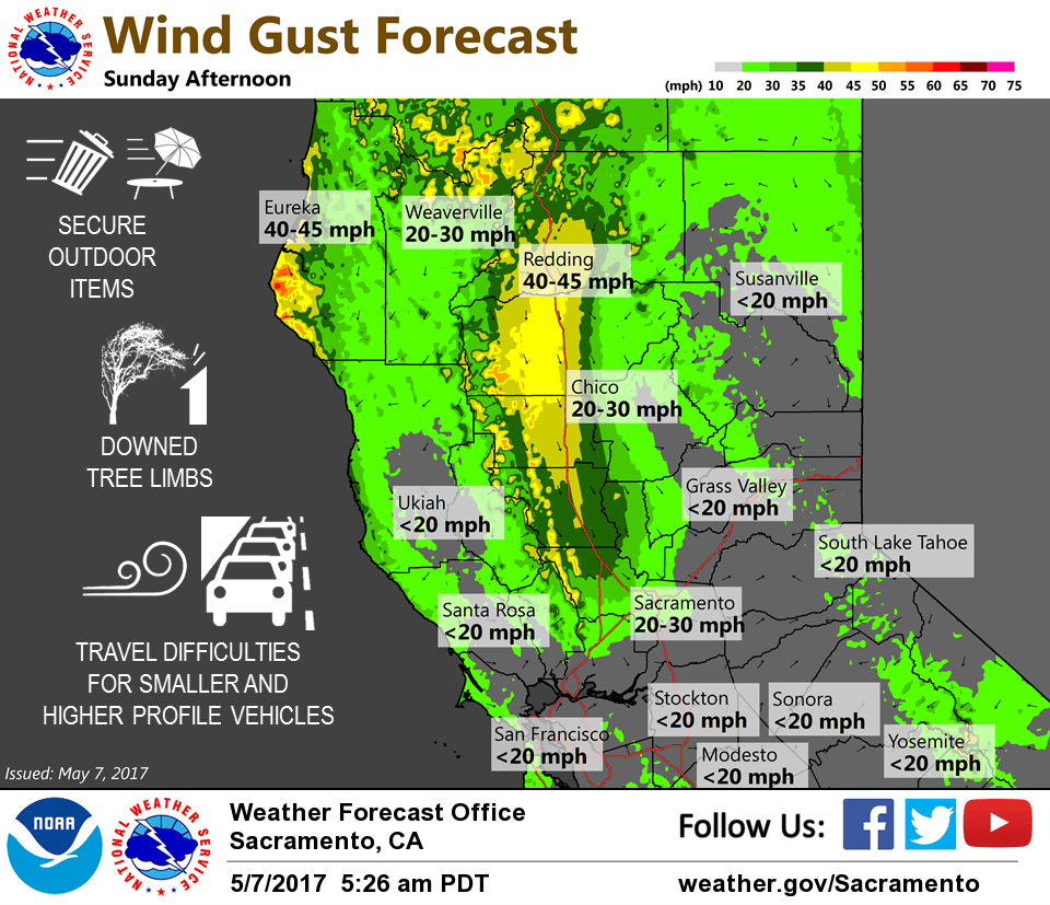
Max Nly pressure gradient about 15 mbs occurred at 13z this morning with the gradient forecast to relax to about 6 or 7 mbs later this afternoon. 925 mbs wind forecast showed the max speeds at 09z and a drastic drop in winds after 18-21z. With weakening pressure gradients and winds (support) aloft, the winds should also be subsiding this afternoon. The LAV guidance shows the winds decreasing below WAD criteria around the 20-21z time frame. The strongest gusts appear to be around 40 mph in the Nrn half of the Sac Vly, and as high as 50-55 mph at Eagle Peak and Knoxville Creek in the Coastal Range.
The gusty Nly winds in the wake of the closed low over SOCAL will result in adiabatic warming with max temps forecast to push into the 80s over the Nrn half of the Sac Vly. This is about 3 to 6 degrees above normal while near normal to below normal max temps are expected elsewhere.
Previous Discussion
Model analysis and water vapor imagery showed an upper level cut off low pressure system moving southward during the early morning hours over California. Lift along the associated trough edge was initiating convection over Nevada, and easterly flow aloft over northern California was bringing light showers into the Sierra and portions of the lower San Joaquin valley overnight. Surface pressure gradient over the Sacramento valley was between 10 and 15 mb, which was causing gusty winds for the northern and central portions of the Sacramento Valley between 30 and 35 mph overnight.
Main forecast concern today is gusty winds and chances for showers and thunderstorms for the Sierra south of I-80. Pressure gradient between the high pressure off the coast and low pressure over the Valley will drive gusty winds across the forecast area today, especially for the Sacramento valley. Lower level jet will also be somewhat strong, so surface gusts could be up to 45 mph through this afternoon. Surface gradient will lessen and winds will become calmer overnight. Breezy winds will pick up again on Monday afternoon, but speeds should not cause much concern. Instability and lift over the Sierra in the presence of the upper low will cause some scattered showers and thunderstorms today. Some brief heavy downpours will be possible with small hail in the stronger developing storms. [Most of the higher resolution model REF progs keep our area generally precip free with the HRRR indicating some showers tracking Wwd towards MOD around 8 pm this evening.]
Upper low proximity on Monday could bring some scattered shower and storms again for the Sierra mountains south of I-80, but chances will be fewer. A building upper level shortwave ridge will bring warming for the beginning of the work week. Temps will be up to 10 degrees above normal Monday and up to 15 degrees above normal for Tuesday. An approaching trough will bring cooling temperatures for Wednesday with readings near to slightly above normal.
Extended discussion (Thursday through Sunday)
High confidence in cooler and breezier conditions returning for interior NorCal after mid-week as upper ridge breaks down and shifts east as another trough sets up along the West Coast. Shower chances expected to be confined to mainly the northern mountains.