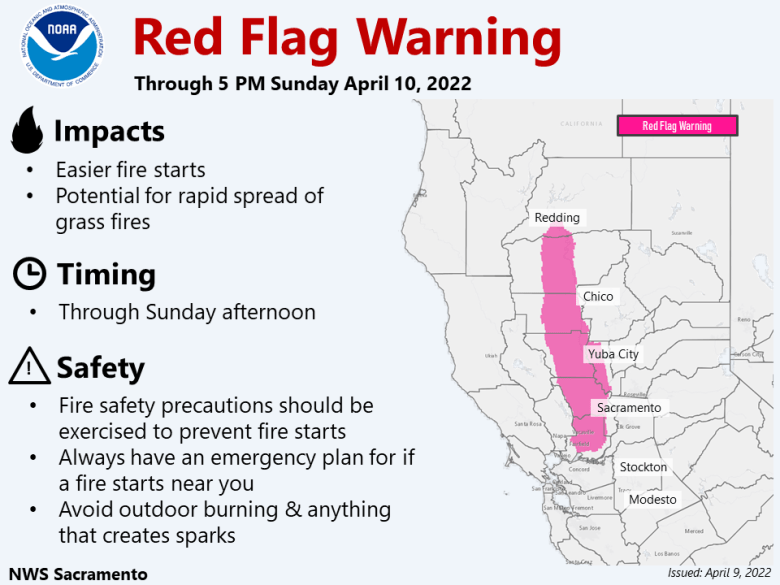
Not as warm today with increasing north winds in the Valley. Combination of strong winds, low humidity, and dry grasses will result in critical fire weather conditions along and west of Interstate 5 today and into Sunday. Valley rain showers and accumulating mountain snow Monday morning into Tuesday with much cooler temperatures.
Discussion
Big day-to-day changes are in store for northern California’s weather beginning today. For one, the heat is a thing of the past…for now. Do not foresee any record highs today as forecast maximums fall a solid 10 to 15 deg F to the 70s (still at or slightly above early April normals).

Second, expect increasingly northerly flow at the surface with winds becoming strong in portions of the Sacramento Valley. This past week’s dominant upper-level ridge responsible for the heat will continue to drift inland today as a trough approaches the Pacific Northwest.
These changes at the synoptic scale will allow for more seasonable temperatures as well as increasing northerly winds. Latest 3-km high-res NAM shows a low-level 925 mb jet increasing along the western half of the Sacramento Valley (along/west of the I-5) in the 40 to 50 kt range with corresponding surface winds sustained 20 to 30 mph with gusts 40 to 50 mph.

Strongest winds will occur during the morning hours Saturday, followed by a brief lull in the afternoon.
By the late afternoon/evening hours Saturday, a renewed burst of strong, gusty winds will redevelop. Can’t rule out some local gusts exceeding 50 mph Saturday evening and Saturday night, particularly in Colusa, Yolo, and Solano Counties. These gusty winds are forecast to gradually subside after sunrise Sunday.
Along with these winds come Fire Weather concerns. The dry northerly breezes earlier this week combined with the multiple days of 85+ deg F heat have further promoted the drying of the grasses in the Sacramento Valley.
Energy Release Components (ERCs) for the Valley specifically remain at record-levels for this time of the year with observed values (as of April 7) matching middle/late June averages.

A combination of the strong winds, low relative humidity values (8-15% afternoon minimums), and dry grasses will lead to critical fire weather conditions.
Consequently, a Red Flag Warning is in effect for a large swath of the Sacramento Valley from 5 AM PDT Saturday to 5 PM PDT Sunday. This is the earliest springtime Red Flag Warning issued by the Sacramento office for interior northern California.

Progressive upper-level pattern will continue to usher in changes for NorCal. In addition to further cooling by Monday, precipitation chances return to the region as an upper-level low arrives to the Pacific Northwest.

While total Valley rain amounts are expected to remain on the light side, moderate snowfall is forecast in the northern Sierra and southern Cascades. Donner Pass has about a 50-60% chance of exceeding 6 inches and about a 20% chance of exceeding 10 inches, per the latest run of the National Blend of Models.
Weather Prediction Center QPF is a bit more bullish, advertising around a foot at the pass level. Will continue to keep a close eye as winter weather headlines will likely be necessary.


Afternoon convection will also possible across the Valley as the upper-level low will allow for increasing lapse rates and instability.
Extended Discussion (Wednesday through Saturday)
Model discrepancies in the extended lead to some forecast uncertainties at this time. Long wave troughing remains over the western states through midweek, but differences exist with track of embedded upper low. Precip looks overdone on EC, but perhaps underdone by GFS.
Forecast leans towards middle ground NBM with a chance of showers, mainly north of I-80 Wed, then over most of the CWA Thursday. Models suggesting mainly lingering chances of mountains showers Friday but turning drier into the weekend.
