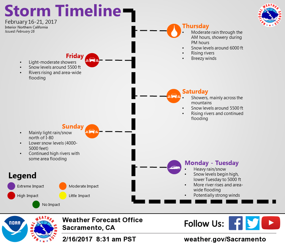
February 16, 2017 – Wet weather returns with several storm system passages expected through next week. Sierra mountain travel issues at times.
Discussion (Tonight through Sunday)
A short break in rain this evening with more rain expected to move into the region late tonight and Friday morning. The center of the surface low will move to near the Bay Area Friday morning and generate strong winds over the interior from around Sacramento southward. The winds should taper early in the evening.
As the low moves closer to the coast rain will spread from a southerly direction to a northerly direction during the day. Most of the rain will occur Friday and Friday night with the rain tapering to showers by Saturday morning. Snow levels look fairly high with this system on Friday near 7000 feet during most of the day and at least into the early evening before lowering to near 5000 feet later at night.
There will be a chance for some showers Saturday and Sunday ahead of the next round of rain and strong winds due to move into the interior later Sunday night. Winds will be much stronger and widespread with heavy rainfall amounts for the foothills and mountains than compared with the Friday system.
Previous Discussion (Today through Sunday)
Current model analysis and water vapor imagery shows the shortwave trough that brought morning rain moving across the Sierra in the early afternoon. The trough base was still working across the Sierra, which was causing some heavier showers and some isolated thunderstorms in the northern Sacramento Valley. Surface pressure gradient in the northern Sacramento Valley has continued to cause some gusty south winds in the northern Valley up to 40 mph at times, with isolated wind gusts up to 30 mph for the central valley (in particular the Oroville and Chico areas).
Latest model guidance has suggested that wind gusts in the northern Valley will continue through mid to late afternoon before diminishing this evening as the shortwave trough aloft passes through the region. Model guidance is still in good agreement to having an upper low deepening off the coast and moving onshore Friday evening, which will bring more rounds for scattered precipitation for the day and increasing chances for Friday evening.
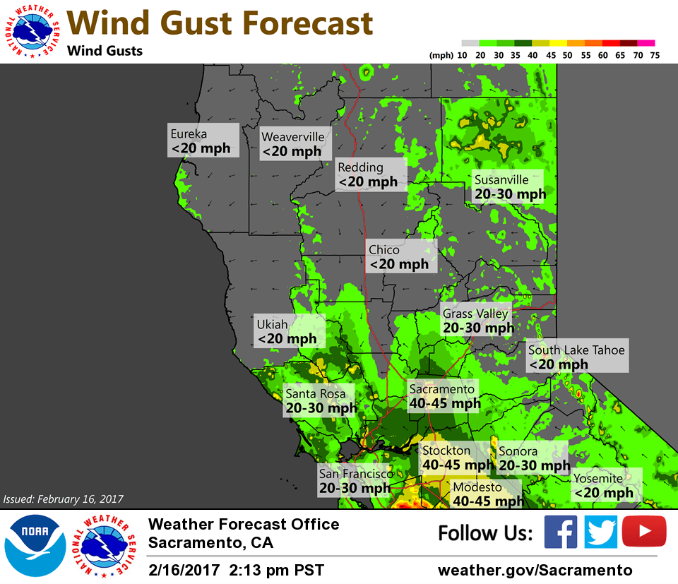
With a stronger low level jet associated with the incoming upper trough and tightening pressure gradient, the southern Sacramento valley and northern San Joaquin valley will likely see increased wind gusts Friday through Friday night. Snow amounts will increase for the Sierra at elevations higher than 5500 feet and could see heavier snow accumulations Friday afternoon through Saturday morning.
The upper level trough continues to linger through the weekend, which will keep chances for rain for the valley and snow for the higher elevations. However, most of the storm is expected to affect southern California during the weekend.
Extended Discussion (Monday through Thursday)
Extended models continue to show the strongest system in the forecast period moving in by early Monday and continuing into Tuesday. While there have been some variations in the exact track of the storm, confidence is high for moderate to heavy precipitation for the northern Sierra/southern Cascades.
What is trickier is which area will be the focus of heaviest precipitation, whether it will be over the Feather River basin or over the American River basin. It looks like the most favorable area will be over the Feather River Basin, with 4 to 8 inches of rain/water equivalent for Monday and Tuesday. The American River Basin (I80 and Highway 50 corridor) should see water equivalent/rain of about 4 to 6 inches, with 1 to 2 feet of snow around and above pass levels. The Valley is forecast to receive about 1-3 inches of rain. This could bring some flooding issues. Additional runoff in the mountains could bring additional mudslides.
Snow levels are another challenging aspect of the forecast. During the day Monday, snow levels are forecast to climb as warm, moist air moves up from the southwest, in the 6000-7000 foot range over the southern Cascades and mountains of western Plumas County, the 7500-8000 foot range for the northern Sierra. Snow levels will drop some Monday night, but exactly how quickly and how far remains uncertain, due to large model run timing differences. The latest GFS drops snow levels to 3500-4000 feet by daybreak Tuesday, while the ECMWF keeps levels around 6000-6500 feet. These levels will affect how much precipitation ends up as snow, and how much is runoff. For now, am going with a blend of both, somewhat favoring the ECMWF for now, which would limit heavier snow to higher elevations.
In addition to precipitation, strong, gusty winds are expected Monday. Gusts of 40 to 50 mph are possible in the Valley, gusting over 55 mph in the Sierra. This coupled with saturated wet ground could bring down trees, causing power outages.
The main upper trough is forecast to move inland later Tuesday into Wednesday resulting in showers across the area, with lowering snow levels and lighter precipitation amounts. Snowfall could cause additional travel problems across the mountains, with snow levels dropping to 3500-4000 feet.
A period of drier weather is expected for late in the week, with mainly just some lingering snow showers in the mountains.