July 31, 2017 – Heatwave this week peaking Tuesday and Wednesday. Isolated late- day thunderstorms possible near the Sierra crest early this week.
Discussion
Clear skies continue across interior NorCal. Temperatures are running a little milder across most of the area and generally range from the upper 50s and 60s through the Delta Breeze influenced areas of the Valley to the 70s to mid 80s across the remainder of the Valley and foothills. Mountain temperatures range from the 50s in the cooler valleys to the 60s and lower 70s elsewhere.
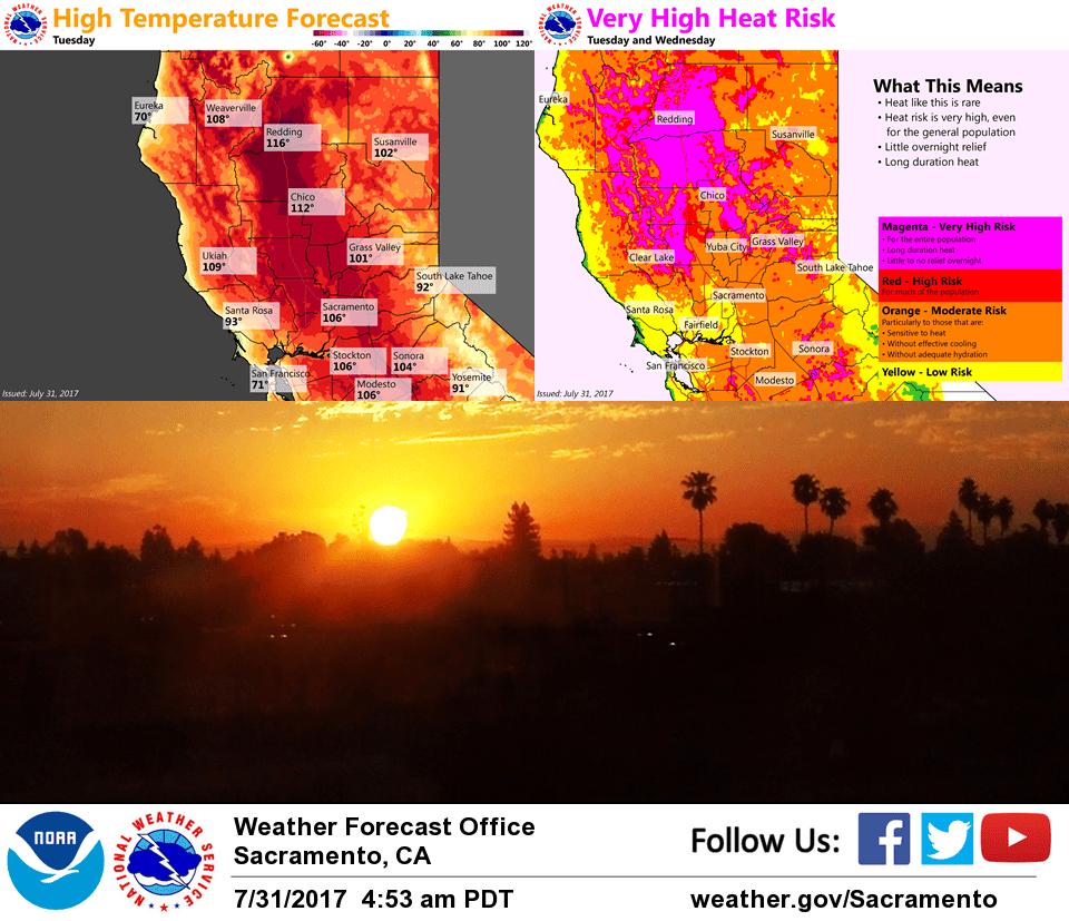
The hottest weather so far this summer is expected thru mid-week across a large part of interior NorCal as strong high pressure continues to build from the Great Basin into the PacNW. Temps will be even hotter today with the upward trend continuing Tuesday, then little change expected Wednesday.
Excessive Heat Warning continues through Thursday for the northern and central Sacramento Valley and northern Coastal Range into the Shasta County Mountains. Record highs will likely fall across the northern Sacramento Valley the next several days, and there is even a non-zero chance of reaching the all-time record high of 118 in Redding on Tuesday or Wednesday (last reached on July 20, 1988). Smoke and haze from wildfires may be the fly in the ointment as they could affect temperatures by several degrees.
Locations further south should be a little less hot, so there is a Heat Advisory through Thursday for the southern Sacramento and northern San Joaquin valleys, eastern Shasta County/Burney Basin, as well as the northern Sierra and mountains of Plumas County (below 6000 feet).
The Delta Breeze will continue the next few days but will have less cooling effect as the marine layer is gradually suppressed. However, this is expected to be enough to take the edge off the extreme heat for the southern half of the forecast area.
A few late-day thunderstorms may manage to pop in the northern Sierra the next few days despite the building ridge. We’ll continue to monitor the potential for moisture increase from the south later this week.
Extended discussion (Friday through Monday)
Strong upper ridge centered over Nevada Friday will gradually weaken and shift east through the extended forecast period as upper trough approaches. This will result in a slow downward trend in temperatures through the weekend but continued above normal. Monsoonal flow will lead to the possibility of afternoon thunderstorms over the mountains.