Multiple rounds of stormy weather will bring periods of valley rain, mountain snow, and gusty winds to Northern California into early next week. Holiday travel will be impacted, especially over mountain passes.

Discussion
Light rain and snow continues this morning over most of the interior and will continue through the day. Snow levels will be rising up to near 5000 feet or better over Shasta County and the coastal range to around 6500 feet over the western slopes.
Snow levels look to remain high enough over the north with the stronger system moving in tonight and Thursday that any impacts should be minimal so have downgraded the warning to an advisory for the coastal range and over Shasta County through Friday. I have also pushed back the start of the warning for the western slopes until 9 pm tonight but heavier precipitation will hold off until midnight over Plumas county and Thursday morning further south over I-80, US-50 and highway 88.
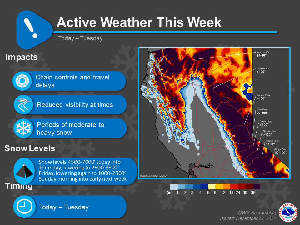
Snow levels look to remain between 4500 and 6000 feet during the day with minor lowering Thursday night. Friday morning snow levels lower to around 3000 feet over Shasta County to 4000 feet over the western slopes.
Decent rainfall may remain over the western slopes from around I-80 southward with area to the north tapering to showers.

Breezy to locally windy conditions are expected later tonight into Thursday as the stronger wave moves over the area. Winds generally 15 to 25 mph with gusts to 35 mph for the valley with locally higher winds possible. Mountains may see gusts 50 to 70 mph over the ridgetops during this time period.
Rainfall amounts through Friday will range from (0.60) inch to (3.00) inches. The higher totals will be over the southern end and eastern portion of the San Joaquin valley were the focus of the precipitation is greatest.
The western slopes will range from (2.00) to (6.00) inches over Western Plumas County to (4.00) to (8.00) inches south of Plumas County with the higher totals from near I-80 south.

Friday night is when the next system begins to move into the region with Saturday and Saturday night having the highest precipitation rates. Snow levels will start out around 3000 to 3500 feet but lowering on Saturday down to 2500 to 3000 feet.
Snow levels will continue to lower Saturday night before bottoming out Sunday morning 1000 to 2000 feet at the tail end of the system. Showers look to continue on Sunday, mostly over the mountains.

This system looks stronger than the first one with the potential to deliver almost twice the amount of snowfall to the higher elevations.
Extended Discussion (Sunday through Wednesday)
A trough will remain over the west coast through the extended period continuing to bring periods of rain/snow to the interior. On Sunday we will be dealing with the back end of the Saturday’s system.
Snow levels will be very low to start the day around 1000 feet up north to 2000 feet in the south although additional precipitation amounts will be light.
The potential for more significant snowfall is forecast for Sunday night through Monday. Snow levels continue to look to be very low varying between 1000 to 2500 feet at times with the lowest snow levels forecast over Shasta County. This will bring a chance of significant snowfall to the foothills.
Snow levels remain low for another potential system Tuesday night and Wednesday although there is some uncertainty with the intensity and placement with this one at this time.