
February 3, 2017 – Wet pattern with rain and mountain snow into Saturday. Gusty winds today. Showers Saturday will be followed by another round of heavier precipitation late Sunday. Wet pattern continuing through next week.
Discussion
Latest satellite image and surface observations indicate the back edge of the Pacific Frontal system now moving through Norcal has moved inland. Moderate rain has begun falling in the northern Sacramento valley and will be shifting southward this morning as the frontal system moves inland.
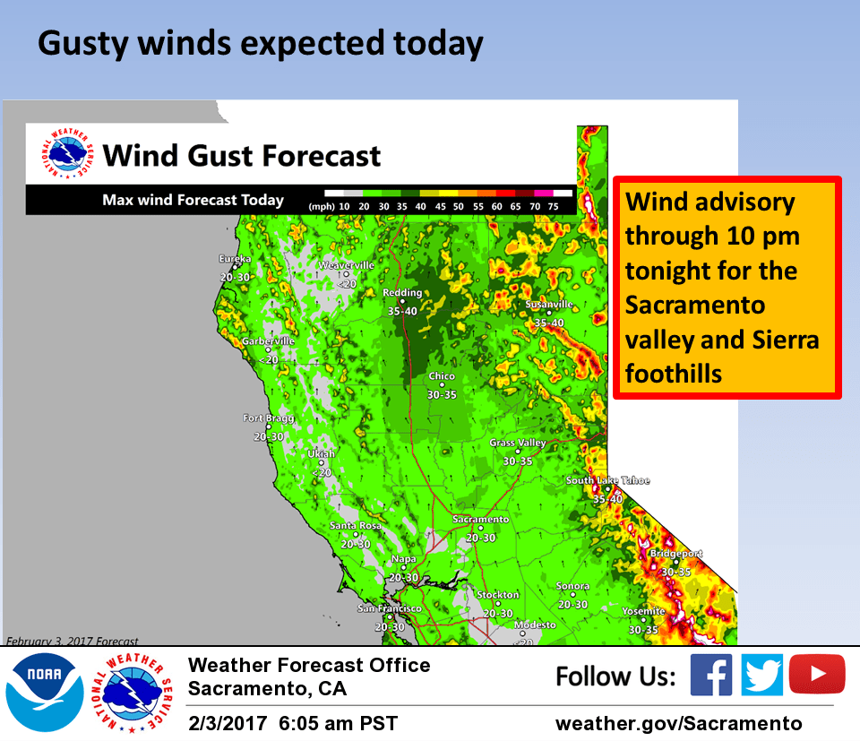
Southerly winds have begun to pick up ahead of the front and will increase over the Sacramento valley as the front approaches. Latest set of guidance indicates the minimal wind advisory criteria should be met at least for a short period of time so have left wind advisory up for now.
High resolution guidance indicates start of precip in the Sacramento area during the commute hours this morning with frontal band moving into the Sierra this afternoon. Models indicate that back edge of front moves east of the Sacramento valley by around 18z today.
Should see enough break in cloud cover to allow enough solar insolation to destabilize the atmosphere this afternoon enough for a threat of thunderstorms throughout the central valley and foothills. Moderate shear exists this afternoon so any thunderstorm development should be watched for possible severe development.
Snow levels are currently right around pass levels and impacts for Sierra travel are currently minimal. Snow levels should lower a bit later this morning however as colder air associated with the front moves in so more impact is likely over the Sierra this morning.
Steady precipitation transitions to showers this evening as the front moves east of the area and moist southwest flow continues over the north state. Moist southwest flow will keep the shower threat going Saturday but precipitation amounts will be decreasing.
Flat upper ridging develops Sunday so many areas could see a break in precipitation for a while although the northern mountains are likely to see continued showers there. Any break in precip will be fairly brief as a low off the Pacific Northwest coast pivots another cold frontal band into Norcal on Sunday night and Monday.
Another round of rain and mountain snow will ensue through the day Monday with snow levels low enough to once again impact Sierra travel. Gusty south winds will return again as well especially during the Monday morning hours.
Extended discussion (Tuesday through Friday)
Models showing wet weather continuing through midweek with overrunning warm frontal precip throughout much of the CWA as warm conveyor belt moisture plume moves inland.
Favorable orographics combined with increased IWV could lead to significant precip amounts into the Sierra Nevada. However most of this expected to be rain as snow levels rise above the passes.
Precip line temporarily shifts northward late Wednesday into early Thursday as downstream upper ridging amplifies. Cold front then progged to move through later Thursday into Friday bringing a period of increased QPF with lowering snow levels.