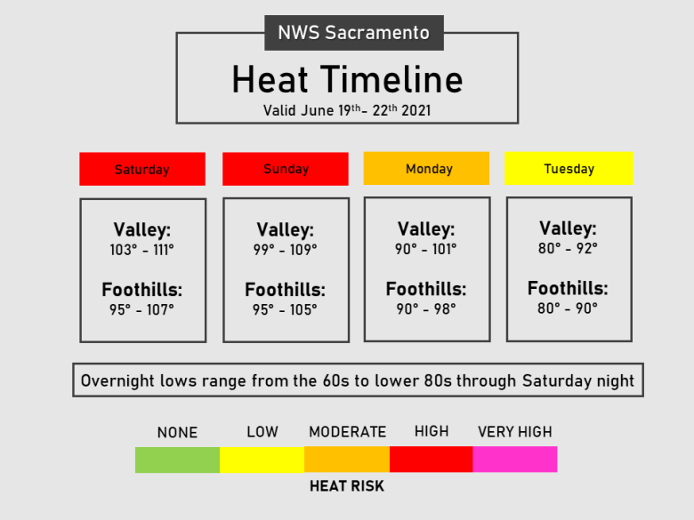
Widespread triple digit heat expected for the lower elevations into this weekend. High to very high heat risk with well above normal temperatures. Excessive Heat Warning until 8 PM Sunday. Cooling trend is expected early next week.

Discussion
Another night of warm overnight lows is being observed early this morning, with lows by sunrise expected to bottom out in the mid 60s to near 80 degrees in the Valley and foothills. High pressure remains across the area today with high to very high heat risk expected to continue for most locations. Onshore flow and the “Delta Breeze” have increased tonight in comparison to the night prior. These winds will help bring a bit of relief to locations near the Delta with highs around 5 to 10 degrees cooler than yesterday. Elsewhere, temperatures may be a degree or two less by this afternoon compared to the day prior, although expect some locations to still reach near their record temperatures.

An upper level low located off the coast of California strengthens tonight into Sunday which will continue onshore flow and strengthen winds near the Delta overnight. For Sunday, the Excessive Heat Warning continues for all areas except near the Delta where cooler overnight lows and daytime highs will warrant the Warning ending Saturday night. Valley and foothill highs elsewhere in the CWA will still see triple digit heat on Sunday with the warmest locations in the northern Sacramento Valley.
The Pacific upper low remains off the coast early next week helping to moderate temperatures back to near normal (or even slightly below normal) values. Models hint at the possibility of a shower over the Coast Range on Tuesday night; however, chances look low and went with a dry NBM forecast at the time. Dry weather continues elsewhere.
Extended discussion (Wednesday through Saturday)
Ensembles and clusters agree that weak closed low will linger off the central California coast during the second half of next week. Temperatures will start out close to average at mid-week, then are expected to climb to well above average by next weekend as the Southwest ridge builds again. Slight chance for a few diurnal thunderstorms over the northern mountains, and potential for elevated convection elsewhere late in the week depending on mid/upper moisture transport from the south.

