Isolated thunderstorms Lake Tahoe south today, otherwise dry. Hot conditions with moderate to high heat risk develop tomorrow into early next week.

Discussion
Short wave trough can be seen via water vapor imagery this morning, with high clouds streaming over NorCal. The main forcing with this system will remain to our south; however, conditions are forecast to become unstable enough to support a slight chance for showers and thunderstorms over the Sierra, primarily from Lake Tahoe south. Conditions continue to favor gusty winds and small hail, with PWAT still near 0.50 inches. Very weak upper level flow is forecast, thus storm motion will be slow and brief heavy downpours can be expected with some of the cells. Once the sun sets the thunderstorm threat will quickly diminish.
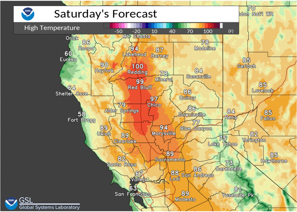
Tomorrow, the strong Pacific Ridge begin to build in which will be the start of our upcoming heat event. 500 mb heights will rise to 590-593 dm by Monday. Most Valley locations should break the century mark for the first time this year on Sunday. Continued warming is expected on Monday which will also likely be our hottest day with highs 103-109 in the Valley, 90s to low 100s in the Foothills and 70s to 80s in the mountains. In addition to these hot summer like conditions, overnight lows will be toasty as well. Valley and adjacent foothill locations will only fall into mid 60s to mid 70s with the warmest overnight lows in the thermal belts. Thus the heat risk category will be high from Sacramento to Redding. An Excessive Heat Warning goes into effect Sunday afternoon and will continue into next week as additional warming is expected.

If you have outdoor plans over the holiday weekend you will want to be prepared for the heat. You can start practicing heat safety now, by looking before you lock your vehicle, wearing sunscreen, and staying hydrated to name a few tips. For more heat safety practices visit weather.gov/safety/heat.

Extended discussion (Wednesday through Saturday)
Main forecast problem in the EFP is the timing/magnitude of the cooling occurring during/after the middle of the week. 5H Cluster Analysis indicates very little variation in the strong ridging pattern over western NOAM on Wed. The ridge axis is forecast to be oriented SW to NE across NorCal and up into the Pac NW and NV/ID areas, with only a slight drop in 850 mbs temps and low to mid level thickness expected.
This brings into question the timing (not so much the magnitude indicated by the Cluster EOF) of the approaching trof with the deterministic models keeping the trof axis W of 130W. We usually like to see the trof axis move inside (or E) of 130W before a significant cooling trend occurs in the interior NorCal area.
However, the Delta (Sea) Breeze may respond to the 2 to 3 days of intense heating in the Valley and may respond to the land-sea temp gradient resulting in a true Sea Breeze. With weakening pressure to the N of our CWA, and the seaward displacement of the Pacific High (ridge), this could be a “Class IIa” Sea Breeze which barely affects max temps at all, especially over areas farther away from the “Delta Influence”. Thus, there remains a “likely” chance (64%) of max temps >=100 at KRDD decreasing to a 38% chance at KRBL on Wed. With the uncertainty in the timing/magnitude of cooling from the Delta Breeze on Wed, we did make an upward adjustment on the max temps in the “Delta influenced” areas, but did keep them below 100 as the probabilistic guidance would suggest.
For the latter half of the EFP there is more variability or uncertainty in the 500 heights over NorCal and the Pac NW amongst ensemble members where “picking a winning model” would be happenstance. Thus we blended between the warmer ECMWF members and the much cooler GFS members with the NBM guidance showing a very low probability of triple digit temps in the northern Sacramento Valley later in the EFP. Therefore, the heat wave will come to an end by the latter half of the week.
Dry forecast continues for the area during the EFP with a low chance of convection on the fringes of our forecast area Wed/Thu.