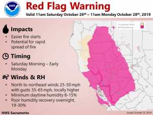
October 26, 2019 – A strong wind event today into early Monday will result in extreme fire weather danger. Enhanced fire weather concerns possible again by the middle of next week. Dry through the extended forecast. Above normal temperatures today then near or below normal temperatures Sunday through next week.
Discussion
Upper trough currently over western Canada will be dropping southeastward today. Most areas will see a little cooling but daytime highs today are still forecast to come in above normal. Surface high pressure nosing into the Pacific Northwest behind this upper trough will bring an increasing northerly gradient across the north state this afternoon. The strongest winds today will be over the Sacramento valley was coast range. These winds will bring continued low humidity in this region elevating fire weather concerns this afternoon and a Red Warning will remain in place for this area today. Northerly surface gradient and upper support increase tonight as the upper trough digs into the central great basin.
Poor overnight recovery and increased wind will bring significant fire weather concerns tonight across nearly all the CWA so the Red Flag warning expands to most of the forecast area. In addition, increased wind speeds overnight through the central valley, parts of the coast range and Sierra strong enough to justify a minimal high wind warning. Surface pressure gradient from MFR to SAC progged at over 15 mb with excellent upper level support so gusts up to 60 mph or more are not unlikely tonight. A strong north wind continues through Sunday as the upper low continues to move into the central Great Basin. Pressure gradients weaken Sunday night so winds will weaken but overnight humidity remains very poor so will leave Red Flag warning up through the Monday morning hours. Lighter northerly breezes continue through Monday afternoon and Tuesday as high pressure aloft nudges in over the west coast. Other than wind and humidity, Fair skies and cooler, near normal, temperatures can be expected Sunday through Tuesday.
Extended Discussion (Wednesday through Saturday)
Eastern Pacific high pressure ridging builds in on Wednesday as an upper trough over the Great Basin exits to the east. While there is some some uncertainty over the exact track of this trough, GEFS and ECMWF ENS are in agreement over the general pattern. Some north to east winds appear likely to develop. While winds do not look nearly as strong as the current event, along with low humidity they could bring the potential for additional fire weather concerns. The ridge pattern will deflect any systems well to the north, maintaining the dry pattern through the end of the week, at least.
High temperatures mid week should be a little below normal, with highs in the low 70s Wednesday then gradually warm to mid to upper 70s late in the week. Optimal radiational cooling will bring overnight lows into the 40s while foothills locations stay in the upper 40s to near 50 across the typical thermal belts.


